ISS023-E-32397
| NASA Photo ID | ISS023-E-32397 |
| Focal Length | 160mm |
| Date taken | 2010.05.04 |
| Time taken | 22:33:22 GMT |
Resolutions offered for this image:
1000 x 662 pixels 540 x 357 pixels 720 x 480 pixels 4256 x 2913 pixels 640 x 438 pixels
1000 x 662 pixels 540 x 357 pixels 720 x 480 pixels 4256 x 2913 pixels 640 x 438 pixels


Cloud masks available for this image:
Spacecraft nadir point: 30.5° N, 80.8° W
Photo center point: 29.4° N, 88.2° W
Photo center point by machine learning:
Photo center point: 29.4° N, 88.2° W
Photo center point by machine learning:
Nadir to Photo Center: West
Spacecraft Altitude: 188 nautical miles (348km)
Country or Geographic Name: | USA-LOUISIANA |
Features: | OIL SPILL, MISSISSIPPI RIVER DELTA, SUNGLINT, CHANDELEUR ISLANDS |
| Features Found Using Machine Learning: | |
Cloud Cover Percentage: | 25 (11-25)% |
Sun Elevation Angle: | 18° |
Sun Azimuth: | 279° |
Camera: | Nikon D3S Electronic Still Camera |
Focal Length: | 160mm |
Camera Tilt: | High Oblique |
Format: | 4256E: 4256 x 2832 pixel CMOS sensor, 36.0mm x 23.9mm, total pixels: 12.87 million, Nikon FX format |
Film Exposure: | |
| Additional Information | |
| Width | Height | Annotated | Cropped | Purpose | Links |
|---|---|---|---|---|---|
| 1000 pixels | 662 pixels | No | Yes | Earth From Space collection | Download Image |
| 540 pixels | 357 pixels | Yes | Yes | Earth From Space collection | Download Image |
| 720 pixels | 480 pixels | Yes | Yes | NASA's Earth Observatory web site | Download Image |
| 4256 pixels | 2913 pixels | No | No | Download Image | |
| 640 pixels | 438 pixels | No | No | Download Image |
Download Packaged File
Download a Google Earth KML for this Image
View photo footprint information
Download a GeoTIFF for this photo
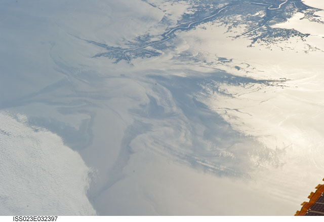
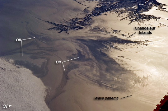
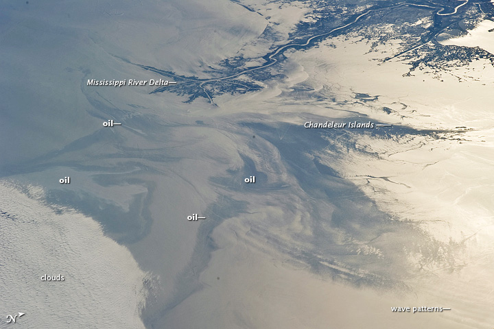
Image Caption: Gulf of Mexico Oil Spill Observed From the International Space Station
On April 20, 2010, the oil rig Deepwater Horizon suffered an explosion and sank two days later. Shortly thereafter, oil began leaking into the Gulf of Mexico from ruptured pipes deep on the ocean floor. NASA satellites have been tracking the growth of the oil spill as it has spread towards the northern Gulf Coast. This detailed astronaut photograph from May 4 provides a different viewing perspective on the ongoing event. The image is oblique, meaning that it was taken from a sideways viewing angle from the International Space Station (ISS), rather than from a "straight down" (or nadir) view, which is typical of automated satellite sensors. The view in this image is towards the west; the ISS was located over the eastern edge of the Gulf of Mexico when the image was taken.
The Mississippi River Delta and nearby Louisiana coast (image top) appear dark in the sunglint that illuminates most of the image. Sunglint is caused by sunlight reflecting off the water surface--much like a mirror--directly back towards the astronaut observer on the Space Station. The sunglint improves the identification of the oil spill. Oil on the water smoothes the surface texture, and the mirror-like reflection of the Sun accentuates the difference between the smooth, oil-covered water (dark to light gray ) and the rougher water of the reflective ocean surface (colored silver to white). Wind and water currents patterns have modified the oil spill's original shape into streamers and elongated masses. Among the coastal ecosystems threatened by the spill are the Chandeleur Islands (image right center).
Other features visible in the image include a solid field of low cloud cover at the lower left corner of the image. V-shaped ship or boat wakes are visible in the large image. Wave patterns at image lower right are most likely caused by tidal effects.
