ISS023-E-29806

| NASA Photo ID | ISS023-E-29806 |
| Focal Length | 800mm |
| Date taken | 2010.04.30 |
| Time taken | 06:59:04 GMT |
Resolutions offered for this image:
1000 x 606 pixels 540 x 327 pixels 720 x 480 pixels 4256 x 2913 pixels 640 x 438 pixels
1000 x 606 pixels 540 x 327 pixels 720 x 480 pixels 4256 x 2913 pixels 640 x 438 pixels
Cloud masks available for this image:
Spacecraft nadir point: 24.3° S, 132.7° E
Photo center point: 25.3° S, 130.8° E
Photo center point by machine learning:
Photo center point: 25.3° S, 130.8° E
Photo center point by machine learning:
Nadir to Photo Center: Southwest
Spacecraft Altitude: 189 nautical miles (350km)
Country or Geographic Name: | AUSTRALIA-NT |
Features: | MOUNT OLGA, DRAINAGE, VEGETATED DUNES, DRAINAGE, ROADS |
| Features Found Using Machine Learning: | |
Cloud Cover Percentage: | 10 (1-10)% |
Sun Elevation Angle: | 21° |
Sun Azimuth: | 298° |
Camera: | Nikon D3S Electronic Still Camera |
Focal Length: | 800mm |
Camera Tilt: | 34 degrees |
Format: | 4256E: 4256 x 2832 pixel CMOS sensor, 36.0mm x 23.9mm, total pixels: 12.87 million, Nikon FX format |
Film Exposure: | |
| Additional Information | |
| Width | Height | Annotated | Cropped | Purpose | Links |
|---|---|---|---|---|---|
| 1000 pixels | 606 pixels | No | Yes | Earth From Space collection | Download Image |
| 540 pixels | 327 pixels | Yes | Yes | Earth From Space collection | Download Image |
| 720 pixels | 480 pixels | Yes | Yes | NASA's Earth Observatory web site | Download Image |
| 4256 pixels | 2913 pixels | No | No | Download Image | |
| 640 pixels | 438 pixels | No | No | Download Image |
Download Packaged File
Download a Google Earth KML for this Image
View photo footprint information
Download a GeoTIFF for this photo
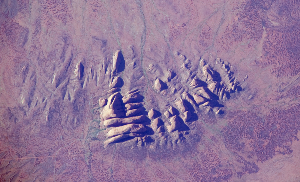
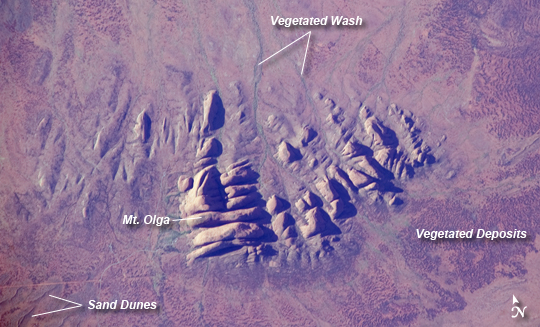
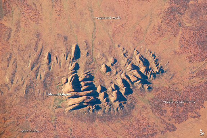
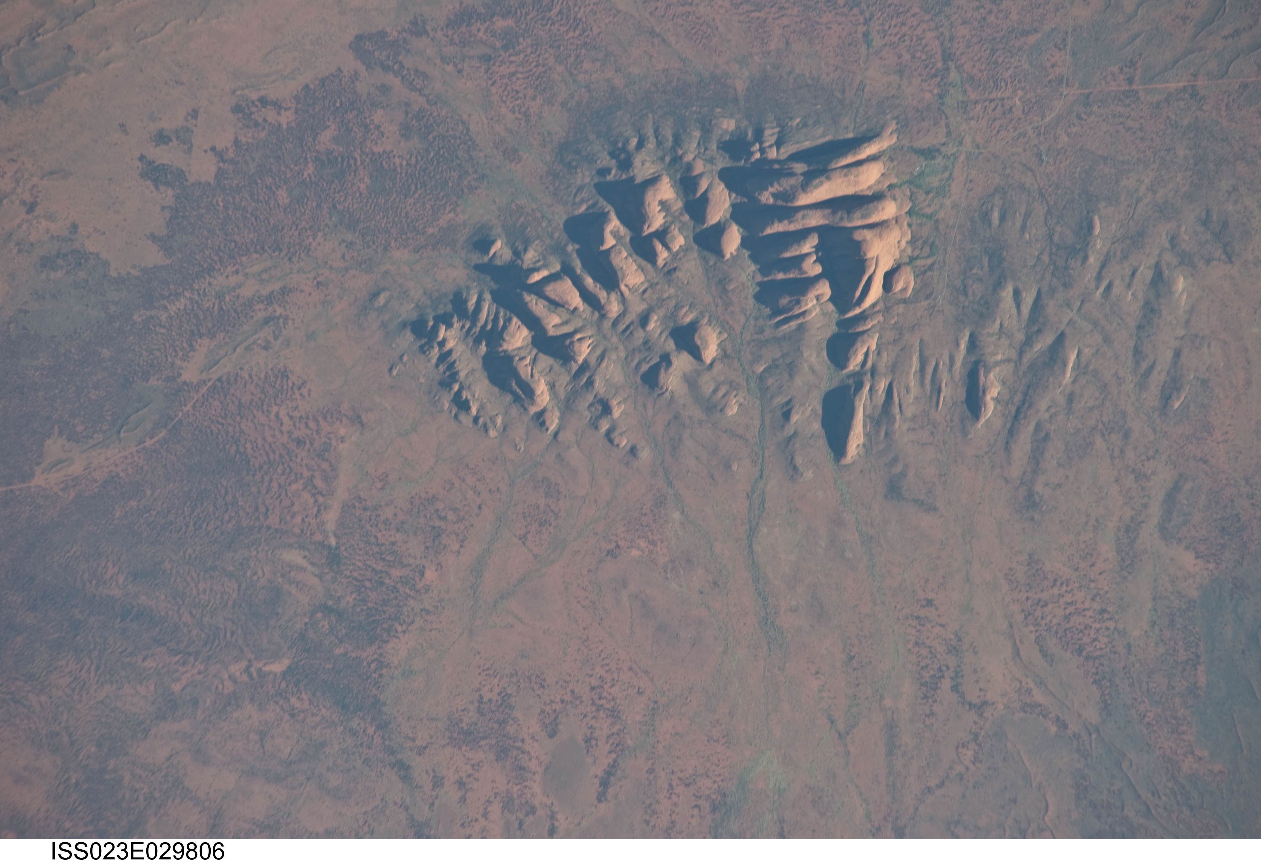
Image Caption: Kata Tjuta (The Olgas), Northern Territory, Australia
Located in the Northern Territory of Australia, Uluru-Kata Tjuta National Park hosts some of the world's most spectacular examples of inselbergs, or isolated mountains. The most famous of these inselbergs is Uluru (also known as Ayers Rock). An equally massive inselberg located approximately 30 kilometers (20 miles) to the northwest is known as Kata Tjuta. Like Uluru, this is a sacred site to the native Anangu or Aboriginal people. An English-born explorer named the highest peak Mount Olga, with the entire grouping of rocks informally known as "the Olgas." Mount Olga has a peak elevation of 1,069 meters (3,507 feet) above sea level, making it 206 meters (676 feet) higher than Uluru.
In this astronaut photograph, afternoon sunlight highlights the rounded summits of Kata Tjuta against the surrounding sandy plains. Sand dunes are visible at image lower left, while in other areas (image bottom and image right) sediments washed from the rocks have been anchored by a variety of grasses and bushes adapted to the arid climate. Green vegetation in the ephemeral stream channels that drain Kata Tjuta (image top center) provides colorful contrast with the red rocks and surrounding soils. Large gaps in the rocks (highlighted by shadows) are thought to be fractures that have been enlarged due to erosion.
Kata Tjuta is comprised of gently dipping Mount Currie Conglomerate, a sedimentary rock that includes rounded fragments of other rock types (here, primarily granite with less abundant basalt and rhyolite in a coarse sandy matrix. Geologists interpret the Mount Currie Conglomerate as a remnant of a large fan of material rapidly eroded from mountains uplifted approximately 550 million years ago. Subsequent burial under younger sediments consolidated the eroded materials to form the conglomerate exposed at the surface today.
