ISS023-E-28353
| NASA Photo ID | ISS023-E-28353 |
| Focal Length | 80mm |
| Date taken | 2010.04.26 |
| Time taken | 12:32:14 GMT |
Resolutions offered for this image:
1000 x 1507 pixels 540 x 814 pixels 720 x 1080 pixels 2913 x 4256 pixels 438 x 640 pixels
1000 x 1507 pixels 540 x 814 pixels 720 x 1080 pixels 2913 x 4256 pixels 438 x 640 pixels
Cloud masks available for this image:
Spacecraft nadir point: 21.0° S, 69.1° W
Photo center point: 26.0° S, 67.5° W
Photo center point by machine learning:
Photo center point: 26.0° S, 67.5° W
Photo center point by machine learning:
Nadir to Photo Center: South
Spacecraft Altitude: 187 nautical miles (346km)
Country or Geographic Name: | ARGENTINA |
Features: | SALAR DE ARIZARO, PUNA, ATACAMA DESERT, VOLCANOES |
| Features Found Using Machine Learning: | PAN- |
Cloud Cover Percentage: | 10 (1-10)% |
Sun Elevation Angle: | 21° |
Sun Azimuth: | 65° |
Camera: | Nikon D3S Electronic Still Camera |
Focal Length: | 80mm |
Camera Tilt: | High Oblique |
Format: | 4256E: 4256 x 2832 pixel CMOS sensor, 36.0mm x 23.9mm, total pixels: 12.87 million, Nikon FX format |
Film Exposure: | |
| Additional Information | |
| Width | Height | Annotated | Cropped | Purpose | Links |
|---|---|---|---|---|---|
| 1000 pixels | 1507 pixels | No | Yes | Earth From Space collection | Download Image |
| 540 pixels | 814 pixels | Yes | Yes | Earth From Space collection | Download Image |
| 720 pixels | 1080 pixels | Yes | Yes | NASA's Earth Observatory web site | Download Image |
| 2913 pixels | 4256 pixels | No | No | Download Image | |
| 438 pixels | 640 pixels | No | No | Download Image |
Download Packaged File
Download a Google Earth KML for this Image
View photo footprint information
Download a GeoTIFF for this photo
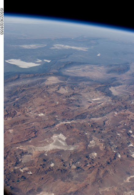
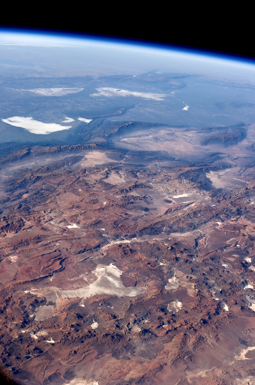
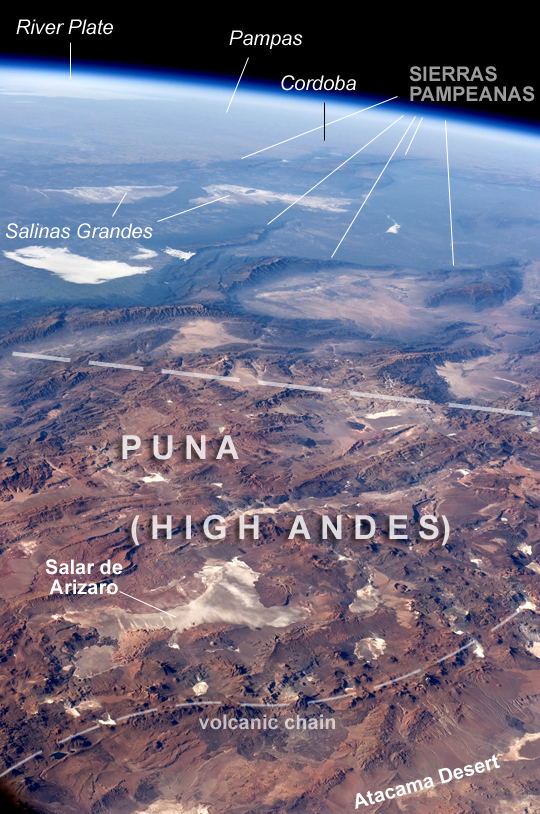
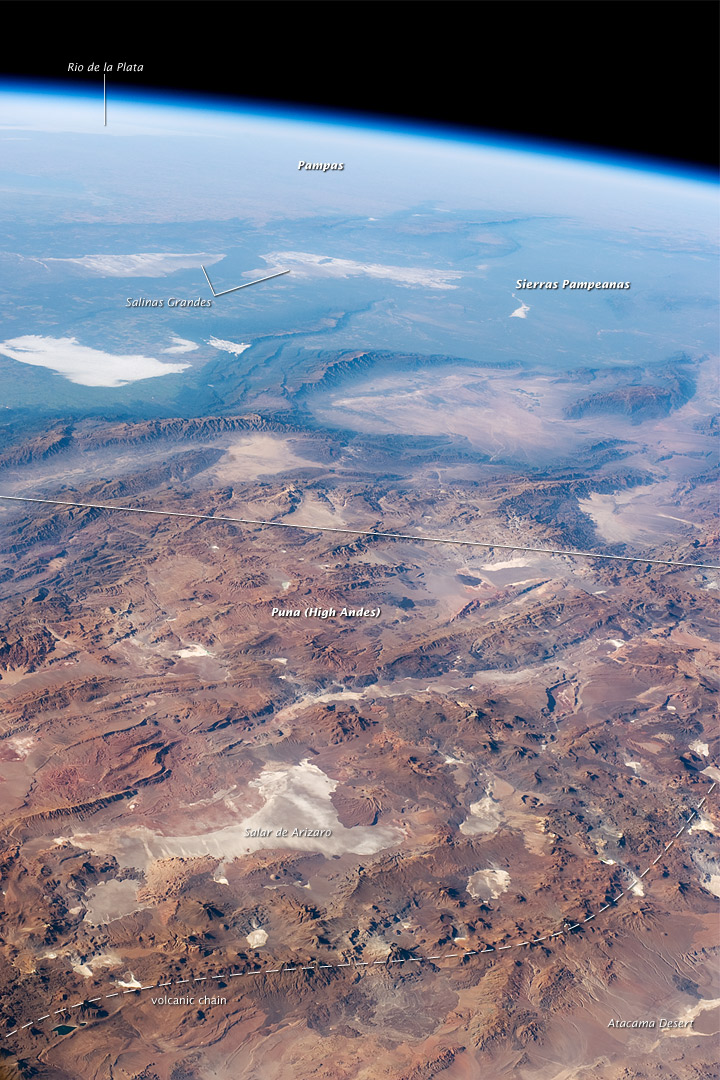
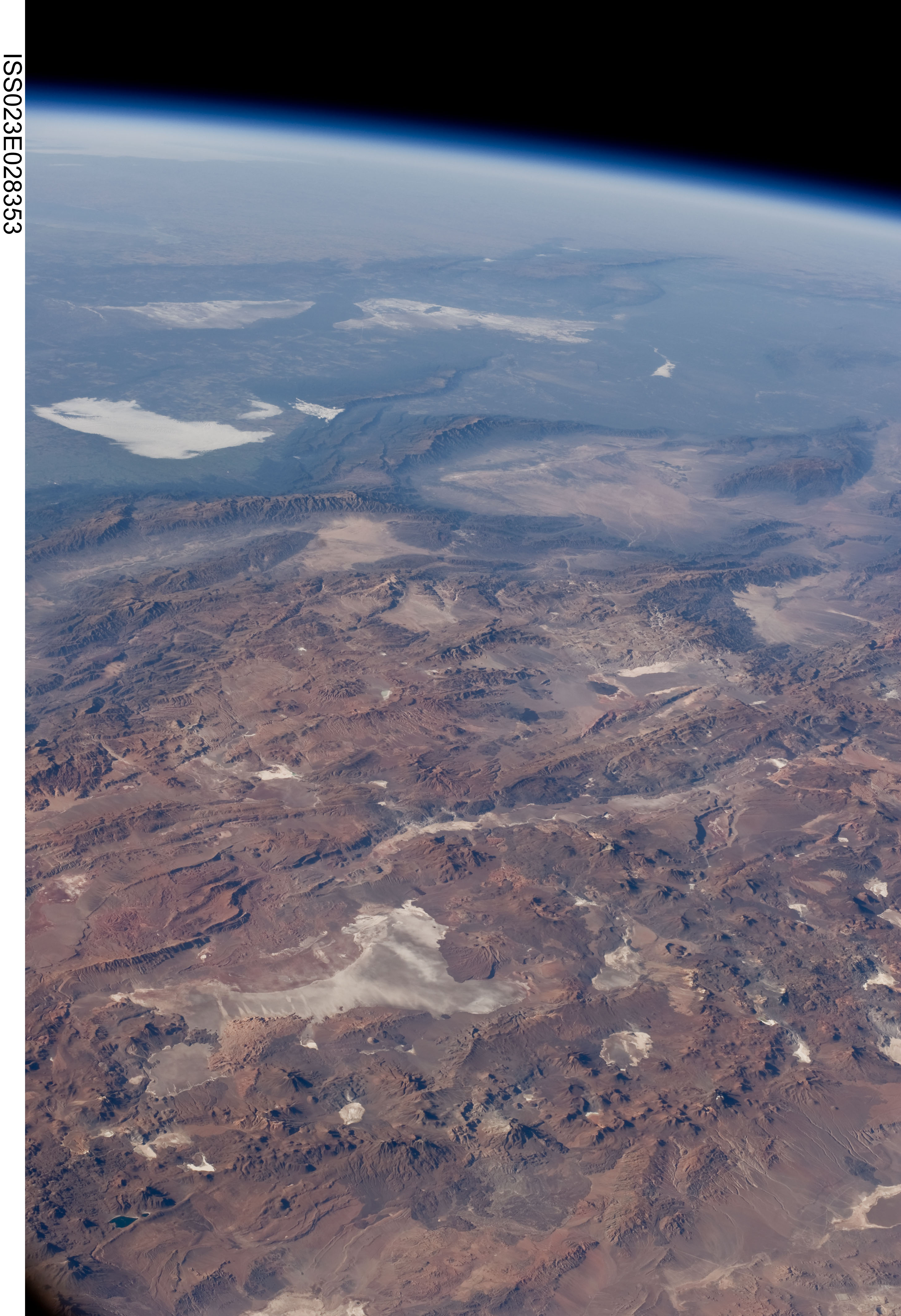
Image Caption: Panorama of Central Andes Mountains, Salar de Arizaro, Argentina
This panorama was taken by an astronaut looking southeast across the South American continent when the International Space Station (ISS) was almost directly over the Atacama Desert near Chile's Pacific coast. The high plains (3000-5000 meters, or 13,000-19,000 feet) of the Andes Mountains, also known as the Puna, appear in the foreground, with a line of young volcanoes (dashed line) facing the much lower Atacama Desert (1000-2000 m elevation). Several salt-crusted dry lakes (known as salars in Spanish) occupy the basins between major thrust faults in the Puna. Salar de Arizaro (foreground) is the largest of the dry lakes in this view. The Atlantic Ocean coastline, where Argentina's capital city of Buenos Aires sits along the Rio de la Plata, is dimly visible at image top left.
Near image center, the transition (solid line) between two distinct geological zones, the Puna and the Sierras Pampeanas, creates a striking landscape contrast. Compared to the Puna, the Sierras Pampeanas mountains are lower in elevation and have fewer young volcanoes. Sharp-crested ridges are separated by wide, low valleys in this region. The Salinas Grandes--ephemeral shallow salt lakes--occupies one of these valleys. The general color change from reds and browns in the foreground to blues and greens in the upper part of the image reflects the major climatic regions: the deserts of the Atacama and Puna versus the grassy plains of central Argentina, where rainfall is sufficient to promote lush prairie grass, known locally as the pampas. The Salinas Grandes mark an intermediate, semiarid region.
What accounts for the changes in topography between the Puna and the Sierras Pameanas? The geology of this part of the Andes is a result of the eastward subduction of the Nazca tectonic plate underneath South America. Seismic data suggest that beneath the Puna, the Nazca Plate is dipping down steeply. Beneath the Sierras Pampeanas zone, however, the underlying Nazca plate is almost horizontal. The levelness may be due to the subduction of a submarine mountain range known as the Juan Fernandez Ridge. In the simplest terms, ridges are topographic highs that are difficult to stuff down into the subduction zone, and that has profound effects on the volcanism and structures of the overlying South America plate.
