ISS022-E-5807
| NASA Photo ID | ISS022-E-5807 |
| Focal Length | 400mm |
| Date taken | 2009.12.03 |
| Time taken | 12:22:43 GMT |
Resolutions offered for this image:
1000 x 664 pixels 540 x 359 pixels 720 x 480 pixels 4288 x 2929 pixels 640 x 437 pixels
1000 x 664 pixels 540 x 359 pixels 720 x 480 pixels 4288 x 2929 pixels 640 x 437 pixels
Cloud masks available for this image:
Spacecraft nadir point: 46.6° N, 22.3° E
Photo center point: 38.5° N, 16.1° E
Photo center point by machine learning:
Photo center point: 38.5° N, 16.1° E
Photo center point by machine learning:
Nadir to Photo Center: Southwest
Spacecraft Altitude: 180 nautical miles (333km)
Country or Geographic Name: | ITALY |
Features: | CALABRIA, CLOUDS, TYRRHENIAN SEA, IONIAN SEA, SUNGLINT |
| Features Found Using Machine Learning: | |
Cloud Cover Percentage: | 50 (26-50)% |
Sun Elevation Angle: | 16° |
Sun Azimuth: | 209° |
Camera: | Nikon D2Xs Electronic Still Camera |
Focal Length: | 400mm |
Camera Tilt: | High Oblique |
Format: | 4288E: 4288 x 2848 pixel CMOS sensor, RGBG imager color filter |
Film Exposure: | |
| Additional Information | |
| Width | Height | Annotated | Cropped | Purpose | Links |
|---|---|---|---|---|---|
| 1000 pixels | 664 pixels | No | Yes | Earth From Space collection | Download Image |
| 540 pixels | 359 pixels | Yes | Yes | Earth From Space collection | Download Image |
| 720 pixels | 480 pixels | Yes | No | NASA's Earth Observatory web site | Download Image |
| 4288 pixels | 2929 pixels | No | No | Download Image | |
| 640 pixels | 437 pixels | No | No | Download Image |
Download Packaged File
Download a Google Earth KML for this Image
View photo footprint information
Download a GeoTIFF for this photo
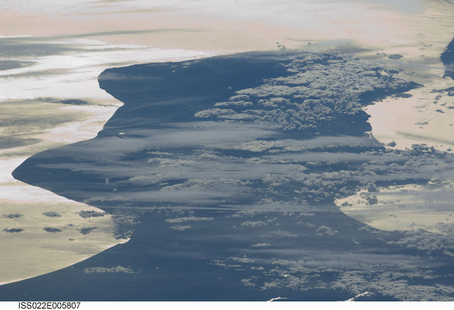
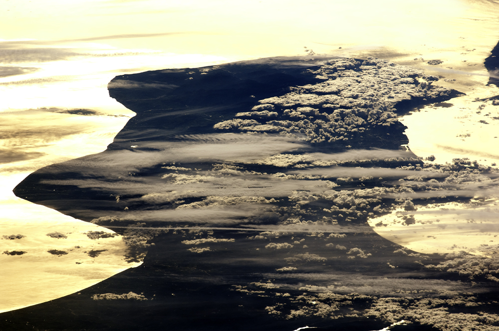
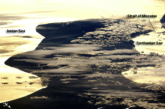
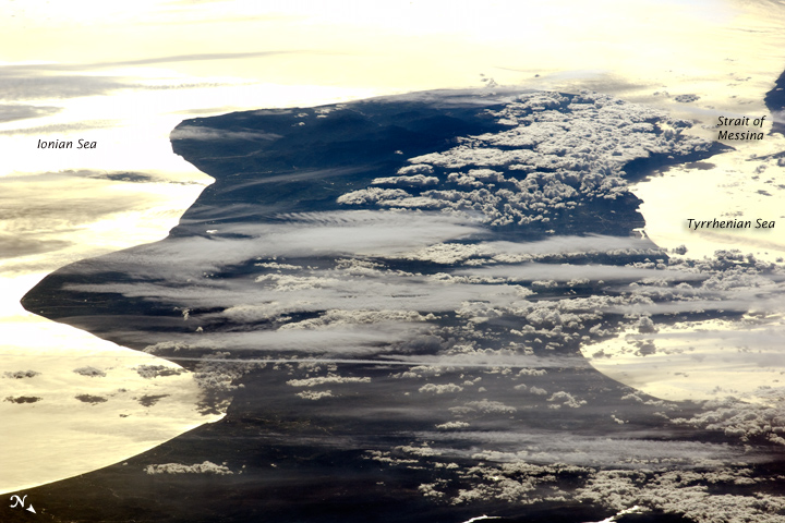
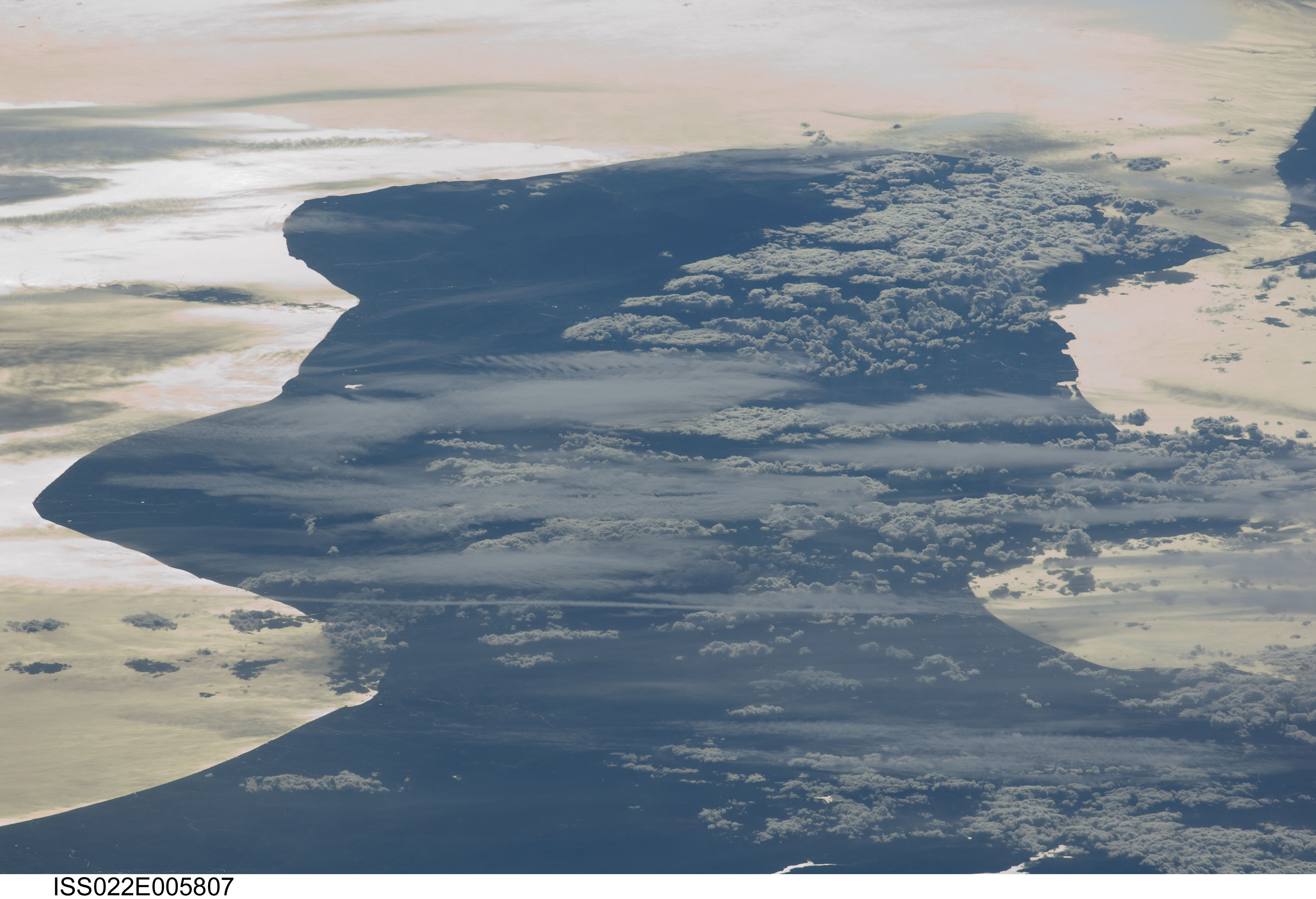
Image Caption: Cloud Formations and Sunglint, Italy
This astronaut photograph shows the Calabria region of southern Italy--the toe of Italy's "boot"--outlined by the Ionian and Tyrrhenian Seas to the southeast and northwest respectively. The water surfaces present a mirror-like appearance due to sunglint. This phenomenon is caused by sunlight reflecting off the water surface directly back towards the astronaut observer on board the International Space Station (ISS). The ISS was located over northwestern Romania, approximately 1,040 kilometers to the northeast of Calabria, when this image was taken.
The Calabrian Peninsula appears shortened and distorted due to the extreme sideways viewing angle from the ISS. Such a perspective is termed oblique, as opposed to a nadir view, in which the astronaut is looking directly downwards towards the Earth's surface from the ISS. This highly oblique view also highlights two distinct cloud patterns over the Calabrian interior. Patchy, highly textured cumulus clouds are present at lower altitudes, while grey altostratus clouds are stretched out by prevailing winds at higher altitudes. The Strait of Messina, just visible at image upper right, marks the boundary between the coastline of Italy and the island of Sicily.
