ISS022-E-5403

| NASA Photo ID | ISS022-E-5403 |
| Focal Length | 400mm |
| Date taken | 2009.12.02 |
| Time taken | 08:45:56 GMT |
Resolutions offered for this image:
1000 x 664 pixels 540 x 359 pixels 720 x 480 pixels 4288 x 2929 pixels 640 x 437 pixels
1000 x 664 pixels 540 x 359 pixels 720 x 480 pixels 4288 x 2929 pixels 640 x 437 pixels
Cloud masks available for this image:
Spacecraft nadir point: 40.5° N, 2.1° E
Photo center point: 43.1° N, 6.2° E
Photo center point by machine learning:
Photo center point: 43.1° N, 6.2° E
Photo center point by machine learning:
Nadir to Photo Center: Northeast
Spacecraft Altitude: 179 nautical miles (332km)
Country or Geographic Name: | FRANCE |
Features: | GIENS PEN., HYERES, AIRPORT, COAST |
| Features Found Using Machine Learning: | |
Cloud Cover Percentage: | 10 (1-10)% |
Sun Elevation Angle: | 16° |
Sun Azimuth: | 138° |
Camera: | Nikon D2Xs Electronic Still Camera |
Focal Length: | 400mm |
Camera Tilt: | High Oblique |
Format: | 4288E: 4288 x 2848 pixel CMOS sensor, RGBG imager color filter |
Film Exposure: | |
| Additional Information | |
| Width | Height | Annotated | Cropped | Purpose | Links |
|---|---|---|---|---|---|
| 1000 pixels | 664 pixels | No | Yes | Earth From Space collection | Download Image |
| 540 pixels | 359 pixels | Yes | Yes | Earth From Space collection | Download Image |
| 720 pixels | 480 pixels | Yes | Yes | NASA's Earth Observatory web site | Download Image |
| 4288 pixels | 2929 pixels | No | No | Download Image | |
| 640 pixels | 437 pixels | No | No | Download Image |
Download Packaged File
Download a Google Earth KML for this Image
View photo footprint information
Download a GeoTIFF for this photo
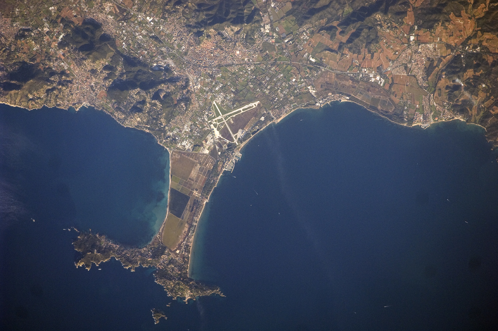
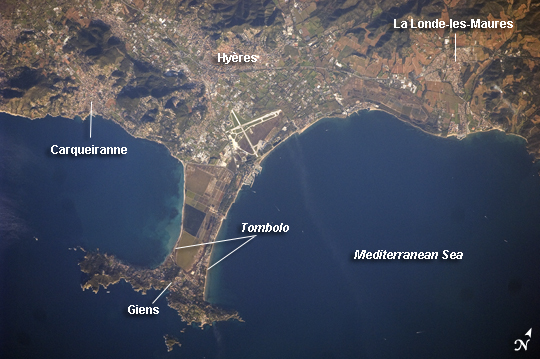
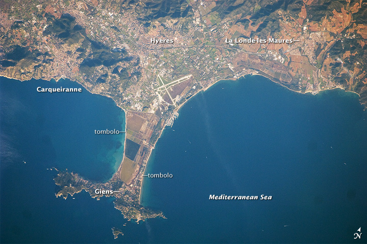
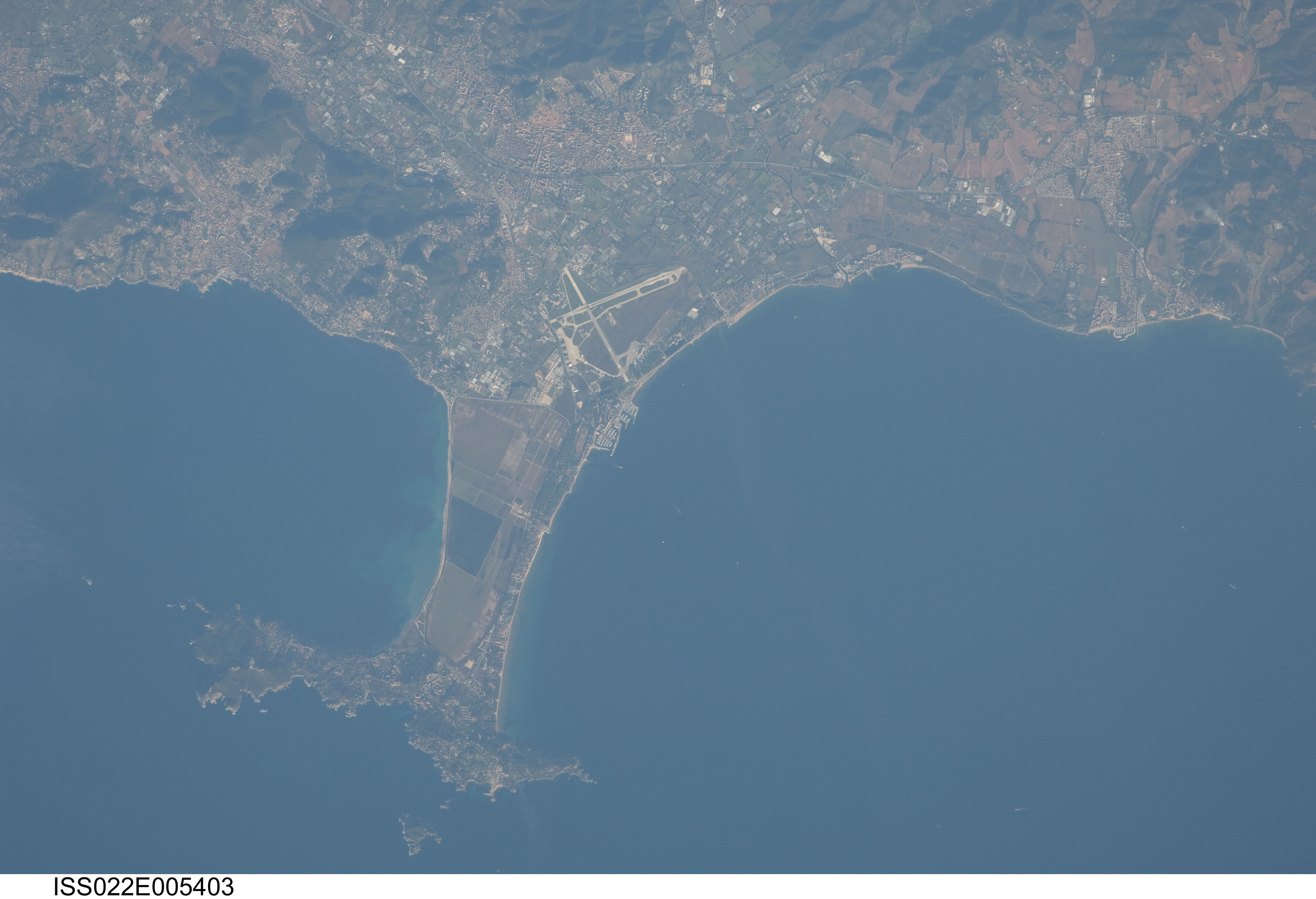
Image Caption: Giens Peninsula, France
This detailed astronaut photograph shows the Giens Peninsula, located along the Mediterranean coastline of France. The peninsula is part of the Cote d'Azur, also known as the French Riviera. The coastal region is bounded by the Rhone River to the west, the Rhone Alps to the north, and the Italian border to the east. The peninsula extends southwards from the city of Hyeres to the resort community of Giens.
The Giens Peninsula is formed from two tombolos. A tombolo is a ridge of beach material (typically sand), built by wave action, that connects an island to the mainland. Tombolos, like many coastal features, typically change dramatically over geologic time due to fluctuating sediment supply, coastal currents, sea levels and storm events. The tombolos of the Giens Peninsula have been modified by human activities, as well, including sand dune removal, construction of roadways, and replacement of the original sand by other materials. The long-term survival of these tombolos will be determined by the effects of these changes on the natural coastal processes, with potential sea level rise presenting an additional threat.
In addition to Giens, three other urban areas are visible in this image: Carqueiranne, Hyeres, and La Londe-les-Maures. The urban areas are recognizable by both light pink rooftops and grey street grids. These colors contrast with green to brown vegetated areas, including agricultural fields between Hyeres and La Londe-les-Maures and more natural vegetation (dark green) on hills between Hyeres and Carqueiranne. Small white dots and streaks in the Mediterranean Sea are yachts and other recreational boats.
