ISS022-E-24940

| NASA Photo ID | ISS022-E-24940 |
| Focal Length | 400mm |
| Date taken | 2010.01.13 |
| Time taken | 10:36:12 GMT |
Resolutions offered for this image:
1000 x 662 pixels 540 x 357 pixels 720 x 480 pixels 4288 x 2929 pixels 640 x 437 pixels
1000 x 662 pixels 540 x 357 pixels 720 x 480 pixels 4288 x 2929 pixels 640 x 437 pixels

Cloud masks available for this image:
Spacecraft nadir point: 23.9° N, 54.2° E
Photo center point: 25.2° N, 55.1° E
Photo center point by machine learning:
Photo center point: 25.2° N, 55.1° E
Photo center point by machine learning:
Nadir to Photo Center: Northeast
Spacecraft Altitude: 183 nautical miles (339km)
Country or Geographic Name: | UNITED ARAB EMIRATES |
Features: | PALM JUMEIRA, THE WORLD I., DUBAI, COAST |
| Features Found Using Machine Learning: | |
Cloud Cover Percentage: | 10 (1-10)% |
Sun Elevation Angle: | 36° |
Sun Azimuth: | 216° |
Camera: | Nikon D2Xs Electronic Still Camera |
Focal Length: | 400mm |
Camera Tilt: | 27 degrees |
Format: | 4288E: 4288 x 2848 pixel CMOS sensor, RGBG imager color filter |
Film Exposure: | |
| Additional Information | |
| Width | Height | Annotated | Cropped | Purpose | Links |
|---|---|---|---|---|---|
| 1000 pixels | 662 pixels | No | Yes | Earth From Space collection | Download Image |
| 540 pixels | 357 pixels | Yes | Yes | Earth From Space collection | Download Image |
| 720 pixels | 480 pixels | Yes | Yes | NASA's Earth Observatory web site | Download Image |
| 4288 pixels | 2929 pixels | No | No | Download Image | |
| 640 pixels | 437 pixels | No | No | Download Image |
Download Packaged File
Download a Google Earth KML for this Image
View photo footprint information
Download a GeoTIFF for this photo
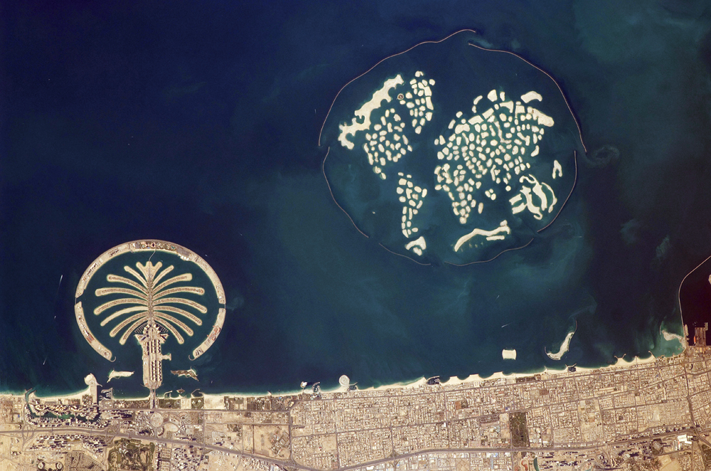
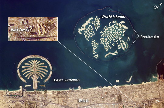
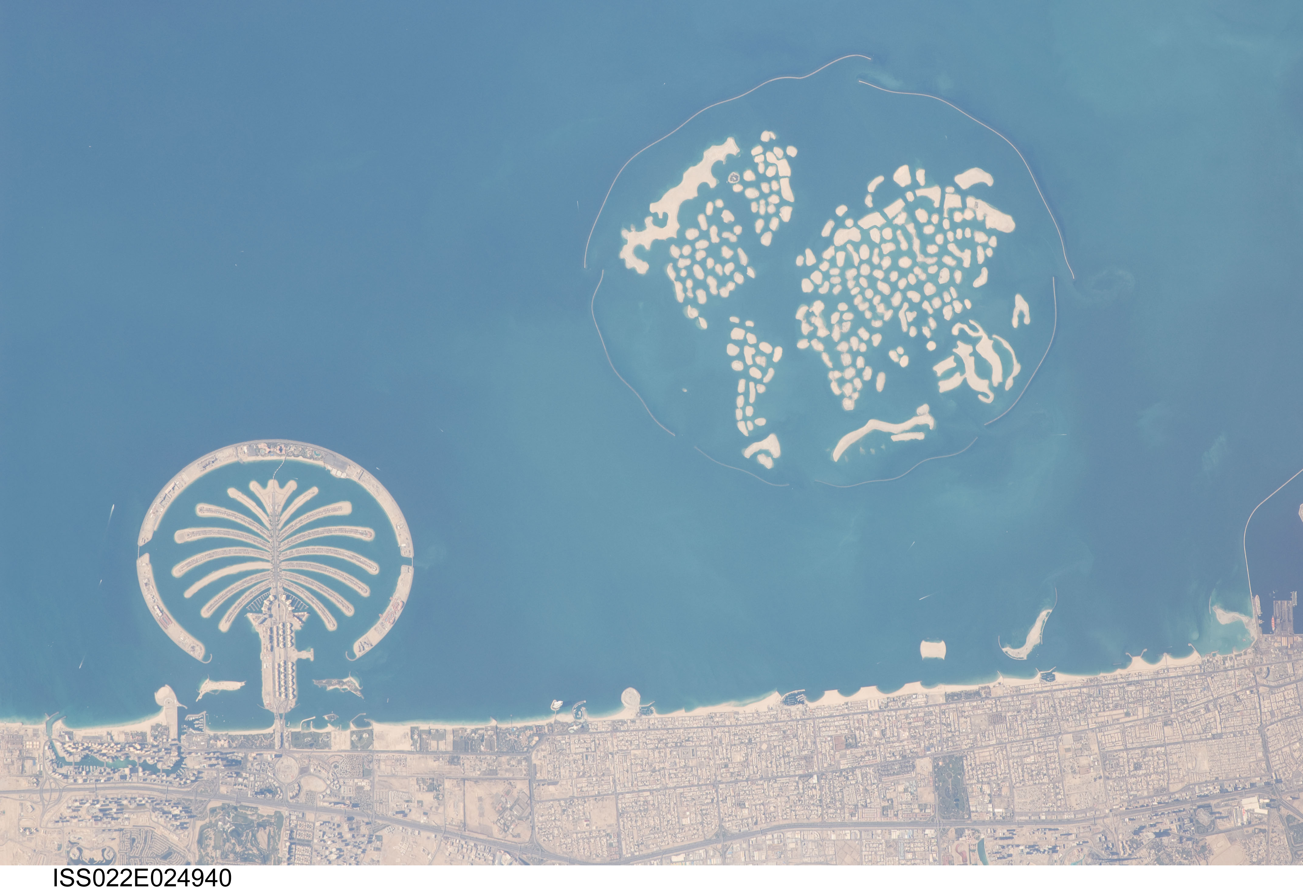
Image Caption: Artificial Archipelagos, Dubai, United Arab Emirates
The municipality of Dubai is the largest city of the Persian Gulf emirate of the same name, and has built a global reputation for large-scale developments and architectural works. Among the most visible of these developments--particularly from the perspective of astronauts on board the International Space Station--are three human-made archipelagos. The two Palm Islands (Palm Jumeirah and Palm Jebel Ali) appear as stylized palm trees when viewed from above. The World Islands evoke a rough map of the world from an air- or space-borne perspective. Palm Jumeirah and the World Islands are highlighted in this astronaut photograph.
Palm Jumeirah (image lower left) was begun in 2001 and required more than 50 million cubic meters of dredged sand to raise the islands above the Persian Gulf sea level. Construction of the Palm Jumeirah islands was completed in 2006; the islands are now being developed for residential and commercial housing and infrastructure. Creation of the 300 World Islands (image upper right) was begun in 2003 and completed in 2008, using 320 million cubic meters of sand and 37 million tonnes of rock for the surrounding 27-kilometer-long protective breakwater. Little to no infrastructure development of The World is apparent in this astronaut photograph.
Also visible at the lower edge of the astronaut photograph is another notable structure--the Burj Khalifa (image lower right and rotated 90 degrees in inset). Burj Khalifa stands 800 meters (2,600 feet) high, and it is currently the world's tallest structure. The astronaut photograph captures enough detail to make out the tapering outline of the building as well as its dark, needle-like shadow pointing towards the northeast.
An earlier astronaut photograph shows an early phase of construction of Palm Jumeirah. The Earth Observatory's World of Change feature also tracks urbanization in Dubai.
