ISS022-E-24557
| NASA Photo ID | ISS022-E-24557 |
| Focal Length | 800mm |
| Date taken | 2010.01.12 |
| Time taken | 08:39:17 GMT |
Resolutions offered for this image:
1000 x 665 pixels 540 x 359 pixels 720 x 480 pixels 6048 x 4147 pixels 640 x 439 pixels
1000 x 665 pixels 540 x 359 pixels 720 x 480 pixels 6048 x 4147 pixels 640 x 439 pixels
Cloud masks available for this image:
Spacecraft nadir point: 5.7° N, 74.2° E
Photo center point: 4.4° N, 73.4° E
Photo center point by machine learning:
Photo center point: 4.4° N, 73.4° E
Photo center point by machine learning:
Nadir to Photo Center: Southwest
Spacecraft Altitude: 185 nautical miles (343km)
Country or Geographic Name: | MALDIVES |
Features: | MALE ATOLL, BODHU HITHI, SUNGLINT |
| Features Found Using Machine Learning: | |
Cloud Cover Percentage: | 10 (1-10)% |
Sun Elevation Angle: | 55° |
Sun Azimuth: | 218° |
Camera: | Nikon D3X Electronic Still Camera |
Focal Length: | 800mm |
Camera Tilt: | 26 degrees |
Format: | 6048E: 6048 x 4032 pixel CMOS sensor, 35.9mm x 24.0mm, total pixels: 25.72 million, Nikon FX format |
Film Exposure: | |
| Additional Information | |
| Width | Height | Annotated | Cropped | Purpose | Links |
|---|---|---|---|---|---|
| 1000 pixels | 665 pixels | No | Yes | Earth From Space collection | Download Image |
| 540 pixels | 359 pixels | Yes | Yes | Earth From Space collection | Download Image |
| 720 pixels | 480 pixels | Yes | Yes | NASA's Earth Observatory web site | Download Image |
| 6048 pixels | 4147 pixels | No | No | Download Image | |
| 640 pixels | 439 pixels | No | No | Download Image |
Download Packaged File
Download a Google Earth KML for this Image
View photo footprint information
Download a GeoTIFF for this photo
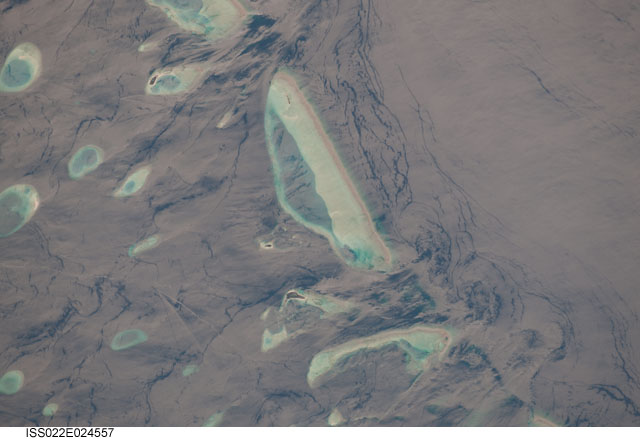
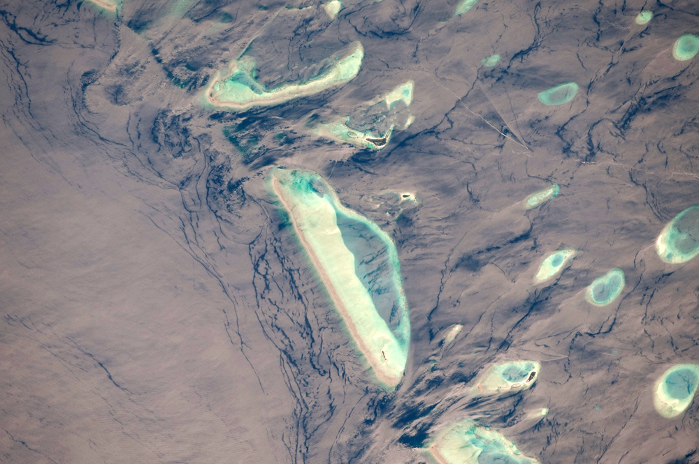
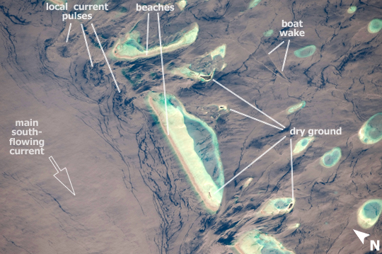
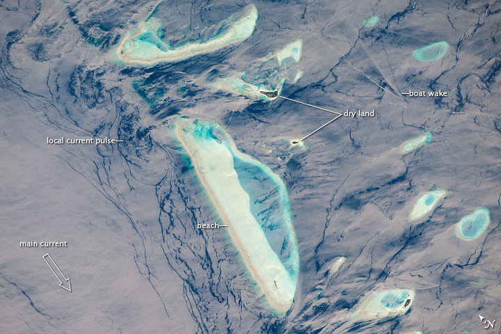
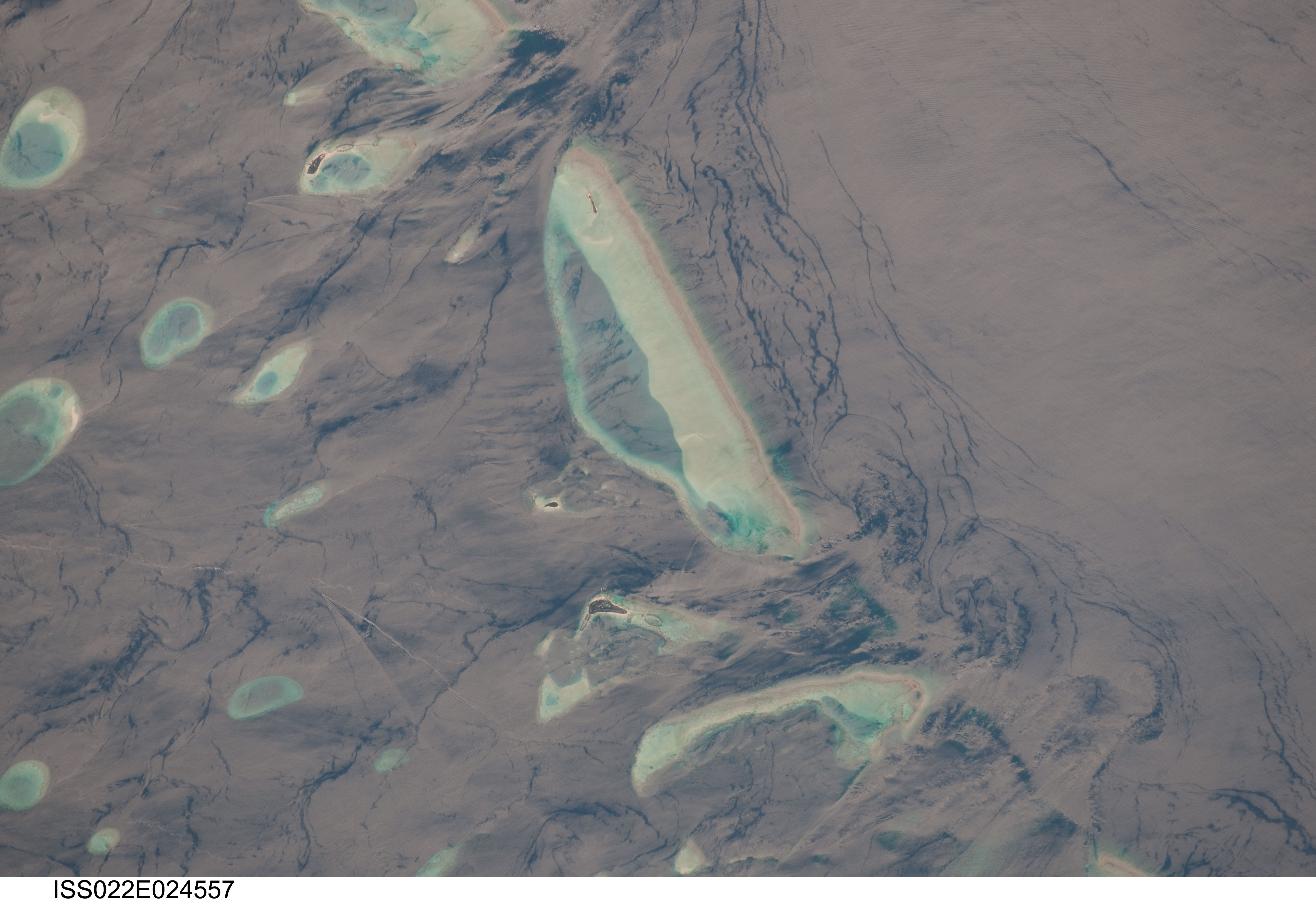
Image Caption: Male Atoll, Maldive Islands, Indian Ocean
This detailed astronaut photograph features one of the numerous atolls in the Maldive Island chain. The Maldives are an island nation, comprised of twenty-six atolls that stretch in a N-S chain for almost 900 km southwest of the Indian subcontinent. The silvery, almost pink sheen on the normally blue water of the equatorial Indian Ocean in the image is the result of sunglint. Sunglint occurs when sunlight is reflected off of a water surface directly back towards the observer - in this case an astronaut on the International Space Station. Full sunglint in images typically results in bright silver to white coloration of the water surface. Sunglint images can have different hues depending on the roughness of the water surface and atmospheric conditions.
Sunglint images can reveal numerous details of water circulation which are otherwise invisible. This image was taken during the Indian Ocean Northeast monsoon season - predominant winds in this area create sinuous surface water patterns on the leeward side, and between, the islets (image left). A south-flowing current flows in the deeper water through the Maldives most of the year (image right), with fan-shaped surface currents formed by local tides pulsing in and out of the shallow water near the islands (image top and bottom).
The largest island seen here (image center) is 6 km long, and is one of the outer ring of larger islands that make up the 70 km-long, oval-shaped Male Atoll. Shores facing deeper water have well-defined beaches. Numerous small, elliptical coral reef islets are protected within the ring of shallow water to the northeast (image left). These islets are mostly awash at high tide, with dry ground appearing in tiny patches only. A small boat was navigating between the islets at the time the image was taken as indicated by its v-shaped wake at image lower left. Images like these illustrate why the Republic of Maldives is one of the most outspoken countries in stressing the dangers of rising sea levels.
