ISS022-E-12224
| NASA Photo ID | ISS022-E-12224 |
| Focal Length | 180mm |
| Date taken | 2009.12.15 |
| Time taken | 18:25:21 GMT |
Resolutions offered for this image:
1000 x 664 pixels 540 x 359 pixels 720 x 480 pixels 4288 x 2929 pixels 640 x 437 pixels
1000 x 664 pixels 540 x 359 pixels 720 x 480 pixels 4288 x 2929 pixels 640 x 437 pixels


Cloud masks available for this image:
Spacecraft nadir point: 22.8° S, 68.0° W
Photo center point: 23.5° S, 68.4° W
Photo center point by machine learning:
Photo center point: 23.5° S, 68.4° W
Photo center point by machine learning:
Nadir to Photo Center: Southwest
Spacecraft Altitude: 187 nautical miles (346km)
Country or Geographic Name: | CHILE |
Features: | EVAPORATION PONDS, SALAR DE ATACAMA |
| Features Found Using Machine Learning: | |
Cloud Cover Percentage: | 10 (1-10)% |
Sun Elevation Angle: | 63° |
Sun Azimuth: | 263° |
Camera: | Nikon D2Xs Electronic Still Camera |
Focal Length: | 180mm |
Camera Tilt: | 14 degrees |
Format: | 4288E: 4288 x 2848 pixel CMOS sensor, RGBG imager color filter |
Film Exposure: | |
| Additional Information | |
| Width | Height | Annotated | Cropped | Purpose | Links |
|---|---|---|---|---|---|
| 1000 pixels | 664 pixels | No | Yes | Earth From Space collection | Download Image |
| 540 pixels | 359 pixels | Yes | Yes | Earth From Space collection | Download Image |
| 720 pixels | 480 pixels | Yes | Yes | NASA's Earth Observatory web site | Download Image |
| 4288 pixels | 2929 pixels | No | No | Download Image | |
| 640 pixels | 437 pixels | No | No | Download Image |
Download Packaged File
Download a Google Earth KML for this Image
View photo footprint information
Download a GeoTIFF for this photo
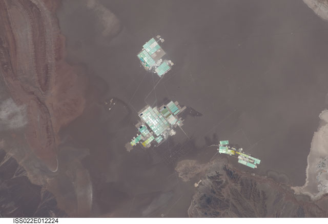
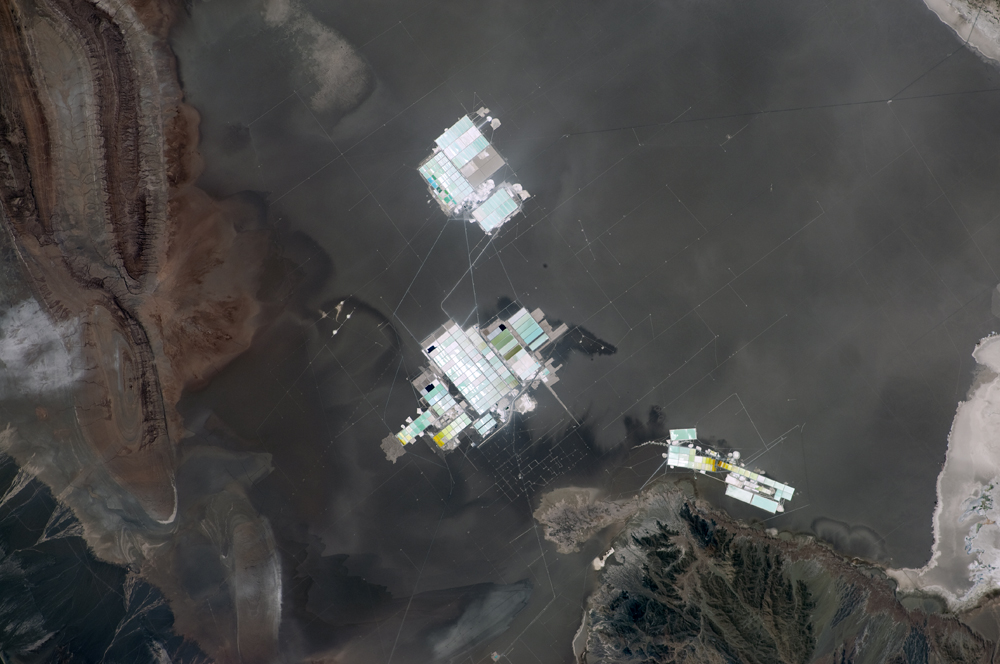
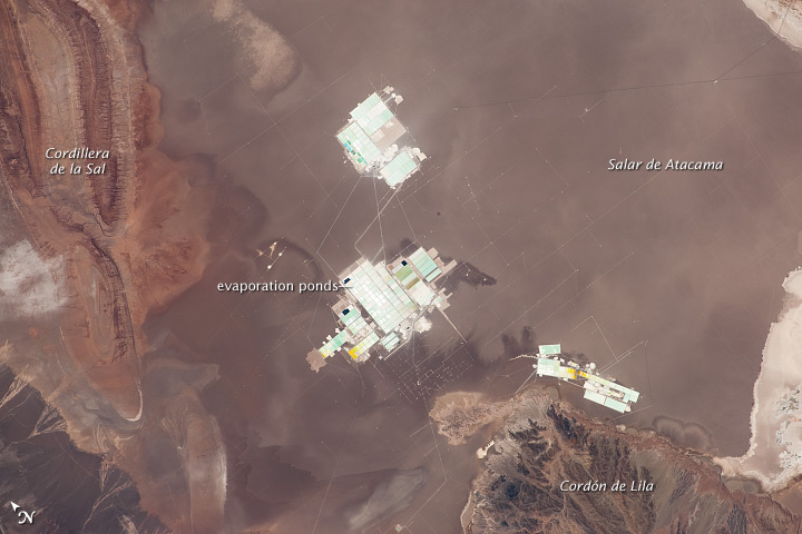
Image Caption: Evaporation Ponds, Salar de Atacama, Chile
The Salar de Atacama in Chile is an enclosed basin with no drainage outlets. (Salar is Spanish for "salt flat.") The salar is located in the southern half of the Atacama Desert; with no historical or current records of rainfall in some parts of this desert, it is considered to be one of the driest places on Earth.
While the grey-brown surface of the salar is flat and desiccated, mineral-rich brines--water with a high percentage of dissolved salts--are located below the surface. The subsurface brines of the Salar de Atacama are particularly rich in lithium salts. Lithium is an essential component of advanced batteries and medicines.
The brines are pumped to the surface through a network of wells and into large, shallow evaporation ponds; three such evaporation facilities are visible in the center of the image. Color variations in the ponds are due to varying amounts of salts relative to water. The dry and windy climate enhances evaporation of the water, leaving concentrated salts behind for extraction of the lithium.
This astronaut photograph illustrates the central portion of the Salar de Atacama. It is bounded by brown to grey-brown folded and faulted rock layers of the Cordillera de la Sal to the northwest (image upper left) and darker bedrock of the Cordon de Lila to the south (image lower right).
