ISS021-E-6635
| NASA Photo ID | ISS021-E-6635 |
| Focal Length | 400mm |
| Date taken | 2009.10.14 |
| Time taken | 17:48:10 GMT |

Cloud masks available for this image:
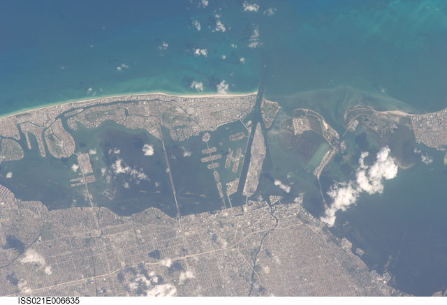
Spacecraft nadir point: 25.2° N, 79.2° W
Photo center point: 25.8° N, 80.2° W
Photo center point by machine learning:
Photo center point: 25.8° N, 80.2° W
Photo center point by machine learning:
Nadir to Photo Center: Northwest
Spacecraft Altitude: 183 nautical miles (339km)
Country or Geographic Name: | USA-FLORIDA |
Features: | PUBLIC INPUTS (from public image detectives, not NASA): FLORIDA, MIAMI, JULIA TUTTLE CAUSEWAY, WATSON ISLAND, MACARTHUR CAUSEWAY, DODGE ISLAND, FISHER ISLAND, VIRGINIA KEY, WILLIAM M POWELL BRIDGE, GROVE ISLE, MIAMI RIVER, INTERSTATE 95, NORTH BAY VILLAGE,MIAMI, KEY BISCAYNE, FISHER ISLAND, VIRGINIA KEY, FLORIDA, ATLANTIC OCEAN, MIAMI BEACHM MARINA, BRIDGE,VENETIAN ISLANDS, DODGE ISLAND, FISHER ISLAND, MIAMI BEACH,MIAMI FL, MIAMI BEACH FL, DODGE ISLAND, VIRGINIA KEY, FISCHER ISLAND, NORTH BAY ISLAND, TREASURE ISLAND, MIAMI RIVER, BISCAYNE BAY |
| Features Found Using Machine Learning: | |
Cloud Cover Percentage: | 10 (1-10)% |
Sun Elevation Angle: | 55° |
Sun Azimuth: | 200° |
Camera: | Nikon D2Xs Electronic Still Camera |
Focal Length: | 400mm |
Camera Tilt: | 20 degrees |
Format: | 4288E: 4288 x 2848 pixel CMOS sensor, RGBG imager color filter |
Film Exposure: | |
| Additional Information | |
| Width | Height | Annotated | Cropped | Purpose | Links |
|---|---|---|---|---|---|
| 4288 pixels | 2929 pixels | No | No | Download Image | |
| 640 pixels | 437 pixels | No | No | Download Image |
Download Packaged File
Download a Google Earth KML for this Image
View photo footprint information
Download a GeoTIFF for this photo
Image Caption: none
