ISS021-E-11832

| NASA Photo ID | ISS021-E-11832 |
| Focal Length | 800mm |
| Date taken | 2009.10.22 |
| Time taken | 10:00:54 GMT |
Resolutions offered for this image:
1000 x 589 pixels 540 x 318 pixels 720 x 480 pixels 3072 x 2098 pixels 640 x 437 pixels
1000 x 589 pixels 540 x 318 pixels 720 x 480 pixels 3072 x 2098 pixels 640 x 437 pixels
Cloud masks available for this image:
Spacecraft nadir point: 31.8° N, 16.9° W
Photo center point: 30.2° N, 15.9° W
Photo center point by machine learning:
Photo center point: 30.2° N, 15.9° W
Photo center point by machine learning:
Nadir to Photo Center: Southeast
Spacecraft Altitude: 184 nautical miles (341km)
Country or Geographic Name: | ATLANTIC OCEAN I(S). |
Features: | SAVAGE ISLANDS, SELVAGEM GRANDE |
| Features Found Using Machine Learning: | |
Cloud Cover Percentage: | 10 (1-10)% |
Sun Elevation Angle: | 31° |
Sun Azimuth: | 129° |
Camera: | Nikon D2Xs Electronic Still Camera |
Focal Length: | 800mm |
Camera Tilt: | 32 degrees |
Format: | 4288E: 4288 x 2848 pixel CMOS sensor, RGBG imager color filter |
Film Exposure: | |
| Additional Information | |
| Width | Height | Annotated | Cropped | Purpose | Links |
|---|---|---|---|---|---|
| 1000 pixels | 589 pixels | No | Yes | Earth From Space collection | Download Image |
| 540 pixels | 318 pixels | Yes | Yes | Earth From Space collection | Download Image |
| 720 pixels | 480 pixels | Yes | Yes | NASA's Earth Observatory web site | Download Image |
| 3072 pixels | 2098 pixels | No | No | Download Image | |
| 640 pixels | 437 pixels | No | No | Download Image |
Download Packaged File
Download a Google Earth KML for this Image
View photo footprint information
Download a GeoTIFF for this photo
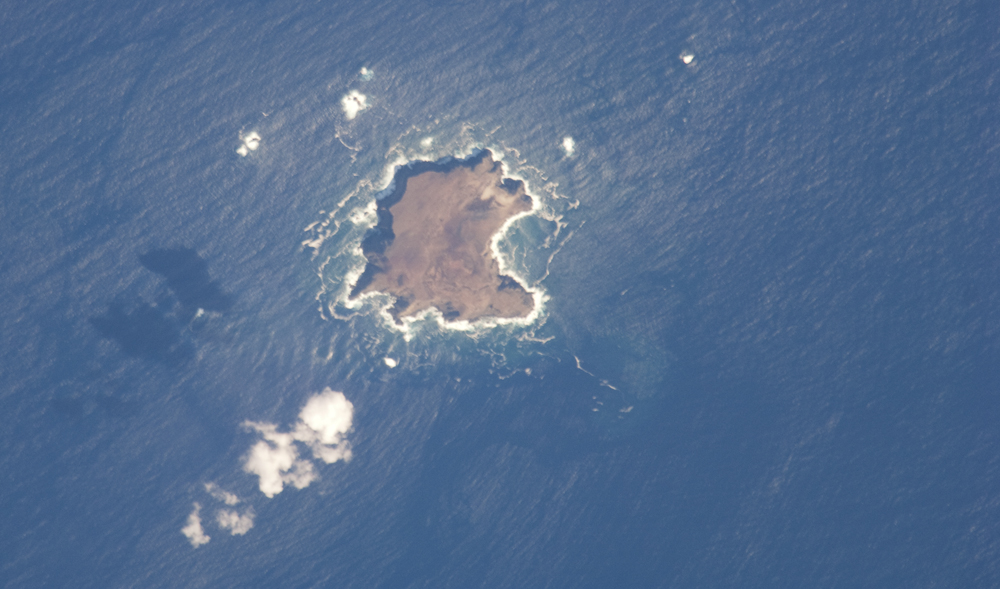
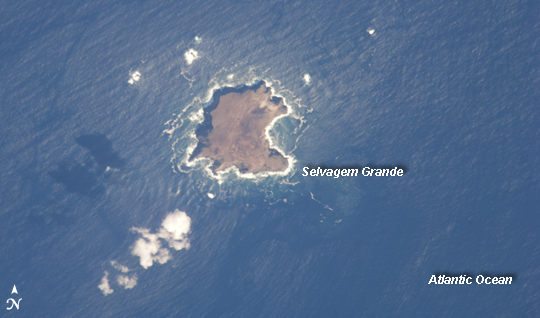
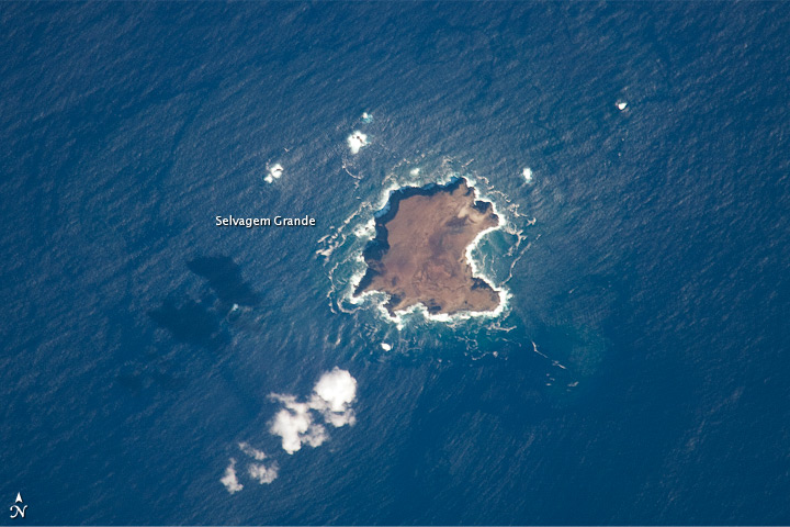
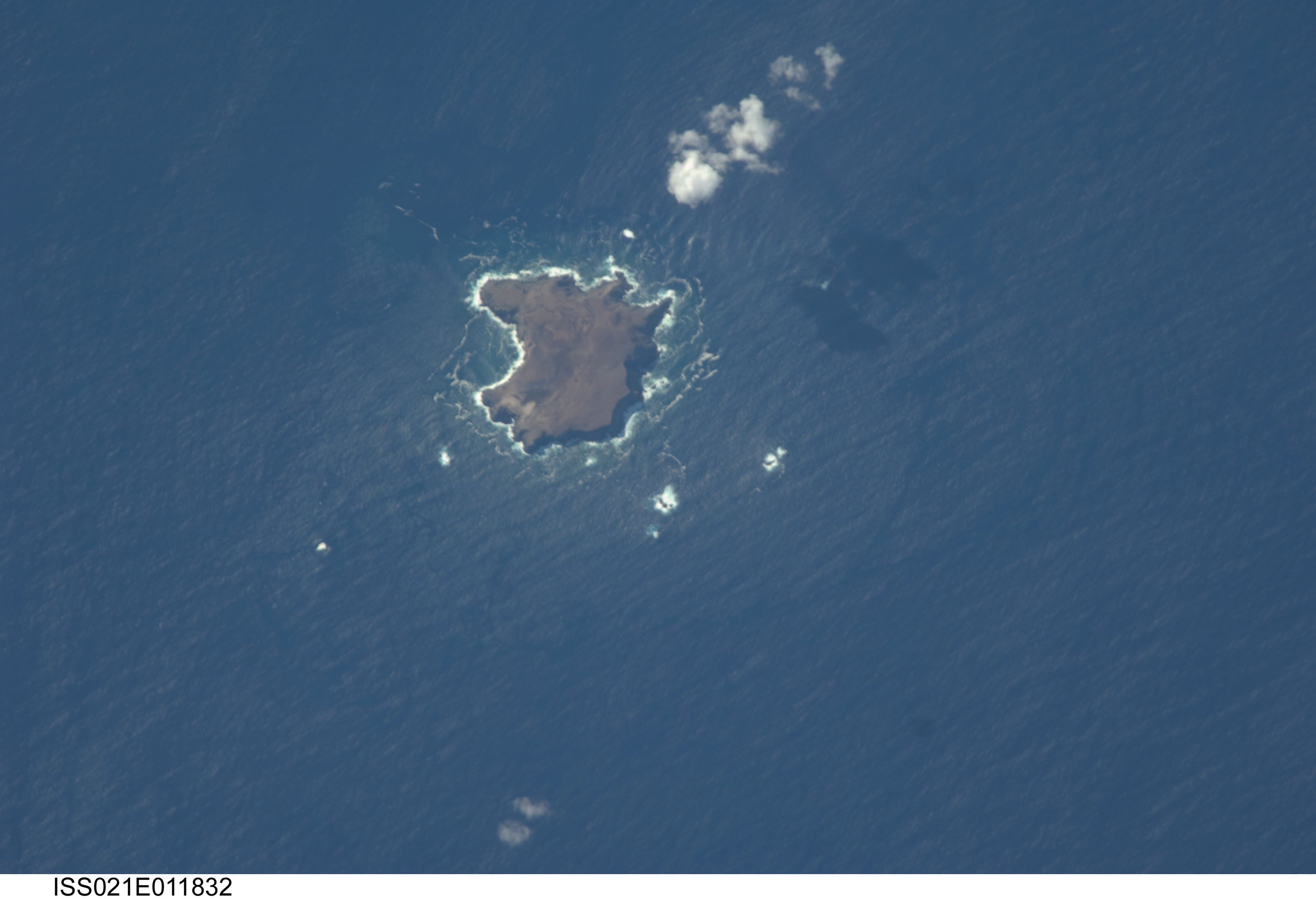
Image Caption: Savage Islands, Atlantic Ocean
The Savage Islands, or Ilhas Selvagens in Portuguese, are a small archipelago in the eastern North Atlantic Ocean between the archipelago of Madeira to the north and the Canary Islands to the south. Like these other island groups, the Savage Islands are thought to have been produced by volcanism related to a mantle plume or "hot spot."
Typically, volcanoes are fueled by magma being generated where tectonic plates are colliding or being pulled apart. The active volcanoes remain at the plate boundaries, even as the plates shift. Mantle plumes, in contrast, are relatively fixed regions of upwelling magma that can feed volcanoes on an overlying tectonic plate. When a tectonic plate passes over the mantle plume, active volcanoes form, but they become dormant as they are carried away from the hot spot on the moving tectonic plate. Over geologic time, this creates a line of older, extinct volcanoes, seamounts, and islands extending from the active volcanoes that are currently over the plume.
These two astronaut photographs illustrate the northern (top) and southern (bottom) Savage Islands. The two views were taken 13 seconds apart from the International Space Station; the geographic center points of the images are separated by about 15 kilometers. Selvagem Grande, with an approximate area of 4 square kilometers, is the largest of the islands. The smaller and more irregularly-shaped Ilheus do Norte, Ilheu de Fora, and Selvagem Pequena are visible at the center of the lower image. Spain and Portugal both claim sovereignty over the Savage Islands.
All of the islands of the archipelago are ringed by bright white breaking waves along the fringing beaches. Reefs that surround the Savage Islands make it very difficult to land boats there, and there is no permanent settlement on the islands. The islands serve as nesting sites for several species of seabird including petrels and shearwaters, and they are included on the tentative list of additional UNESCO World Heritage Sites.
