ISS020-E-9048
| NASA Photo ID | ISS020-E-9048 |
| Focal Length | 400mm |
| Date taken | 2009.06.12 |
| Time taken | 22:16:14 GMT |
Resolutions offered for this image:
1000 x 759 pixels 540 x 410 pixels 720 x 480 pixels 4288 x 2929 pixels 640 x 437 pixels
1000 x 759 pixels 540 x 410 pixels 720 x 480 pixels 4288 x 2929 pixels 640 x 437 pixels

Cloud masks available for this image:
Spacecraft nadir point: 48.8° N, 157.5° E
Photo center point: 48.1° N, 153.2° E
Photo center point by machine learning:
Photo center point: 48.1° N, 153.2° E
Photo center point by machine learning:
Nadir to Photo Center: West
Spacecraft Altitude: 182 nautical miles (337km)
Country or Geographic Name: | RUSSIAN FEDERATION |
Features: | MATUA ISLAND, VOLCANIC PLUME, ASH CLOUD |
| Features Found Using Machine Learning: | |
Cloud Cover Percentage: | 100 (76-100)% |
Sun Elevation Angle: | 44° |
Sun Azimuth: | 106° |
Camera: | Nikon D2Xs Electronic Still Camera |
Focal Length: | 400mm |
Camera Tilt: | High Oblique |
Format: | 4288E: 4288 x 2848 pixel CMOS sensor, RGBG imager color filter |
Film Exposure: | |
| Additional Information | |
| Width | Height | Annotated | Cropped | Purpose | Links |
|---|---|---|---|---|---|
| 1000 pixels | 759 pixels | No | Yes | Earth From Space collection | Download Image |
| 540 pixels | 410 pixels | Yes | Yes | Earth From Space collection | Download Image |
| 720 pixels | 480 pixels | Yes | Yes | NASA's Earth Observatory web site | Download Image |
| 4288 pixels | 2929 pixels | No | No | Download Image | |
| 640 pixels | 437 pixels | No | No | Download Image |
Download Packaged File
Download a Google Earth KML for this Image
View photo footprint information
Download a GeoTIFF for this photo
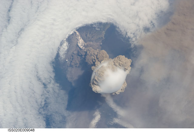
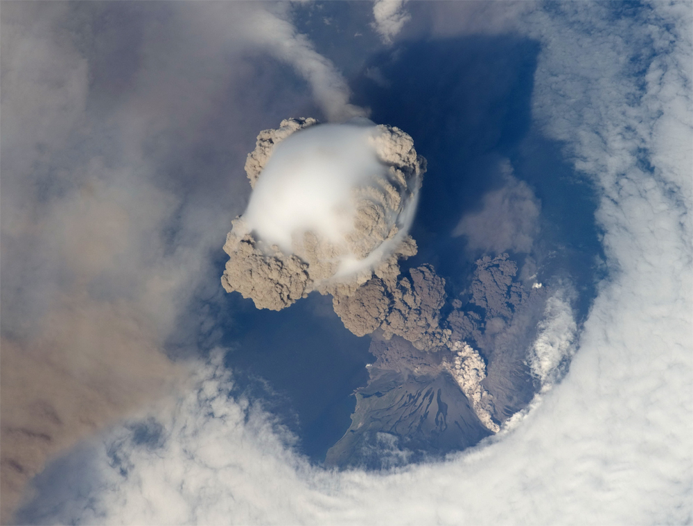
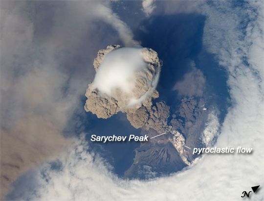
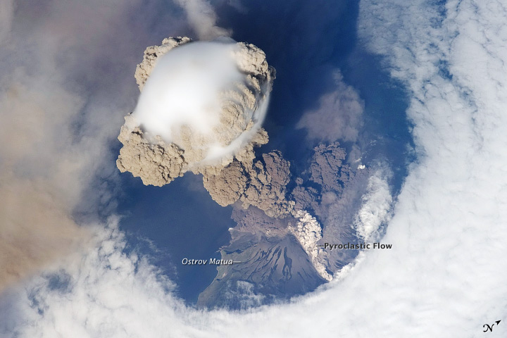
Image Caption: Sarychev Peak Eruption, Kuril Islands
A fortuitous orbit of the International Space Station allowed the astronauts this striking view of Sarychev Volcano (Kuril Islands, northeast of Japan) in an early stage of eruption on June 12, 2009. Sarychev Peak is one of the most active volcanoes in the Kuril Island chain, and it is located on the northwestern end of Matua Island. Prior to June 12, the last explosive eruption occurred in 1989, with eruptions in 1986, 1976, 1954, and 1946 also producing lava flows. Ash from the multi-day eruption has been detected 2,407 kilometers east-southeast and 926 kilometers west-northwest of the volcano, and commercial airline flights are being diverted away from the region to minimize the danger of engine failures from ash intake.
This detailed astronaut photograph is exciting to volcanologists because it captures several phenomena that occur during the earliest stages of an explosive volcanic eruption. The main column is one of a series of plumes that rose above Matua Island on June 12. The plume appears to be a combination of brown ash and white steam. The vigorously rising plume gives the steam a bubble-like appearance.
In contrast, the smooth white cloud on top may be water condensation that resulted from rapid rising and cooling of the air mass above the ash column. This cloud, which meteorologists call a pileus cloud, is probably a transient feature: the eruption plume is starting to punch through. The structure also indicates that little to no shearing wind was present at the time to disrupt the plume. (Satellite images acquired 2-3 days after the start of activity illustrate the effect of shearing winds on the spread of the ash plumes across the Pacific Ocean.)
By contrast, a cloud of denser, gray ash - probably a pyroclastic flow - appears to be hugging the ground, descending from the volcano summit. The rising eruption plume casts a shadow to the northwest of the island. Brown ash at a lower altitude of the atmosphere spreads out above the ground at image lower left. Low-level stratus clouds approach Matua Island from the east, wrapping around the lower slopes of the volcano. Only about 1.5 kilometers of the coastline of Matua Island are visible beneath the clouds and ash.
