ISS020-E-28072
| NASA Photo ID | ISS020-E-28072 |
| Focal Length | 400mm |
| Date taken | 2009.08.05 |
| Time taken | 07:40:40 GMT |
Resolutions offered for this image:
1000 x 733 pixels 540 x 396 pixels 720 x 540 pixels 4256 x 2913 pixels 640 x 438 pixels
1000 x 733 pixels 540 x 396 pixels 720 x 540 pixels 4256 x 2913 pixels 640 x 438 pixels
Cloud masks available for this image:
Spacecraft nadir point: 43.6° N, 34.0° E
Photo center point: 44.6° N, 33.5° E
Photo center point by machine learning:
Photo center point: 44.6° N, 33.5° E
Photo center point by machine learning:
Nadir to Photo Center: North
Spacecraft Altitude: 187 nautical miles (346km)
Country or Geographic Name: | UKRAINE |
Features: | SEVASTOPOL, C. KHERSONESSKIY, FOR., AGR., HILLS |
| Features Found Using Machine Learning: | |
Cloud Cover Percentage: | 10 (1-10)% |
Sun Elevation Angle: | 52° |
Sun Azimuth: | 124° |
Camera: | Nikon D3 Electronic Still Camera |
Focal Length: | 400mm |
Camera Tilt: | 20 degrees |
Format: | 4256E: 4256 x 2832 pixel CMOS sensor, 36.0mm x 23.9mm, total pixels: 12.87 million, Nikon FX format |
Film Exposure: | |
| Additional Information | |
| Width | Height | Annotated | Cropped | Purpose | Links |
|---|---|---|---|---|---|
| 1000 pixels | 733 pixels | No | Yes | Earth From Space collection | Download Image |
| 540 pixels | 396 pixels | Yes | Yes | Earth From Space collection | Download Image |
| 720 pixels | 540 pixels | Yes | Yes | NASA's Earth Observatory web site | Download Image |
| 4256 pixels | 2913 pixels | No | No | Download Image | |
| 640 pixels | 438 pixels | No | No | Download Image |
Download Packaged File
Download a Google Earth KML for this Image
View photo footprint information
Download a GeoTIFF for this photo
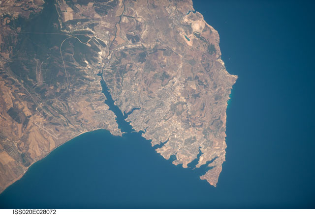
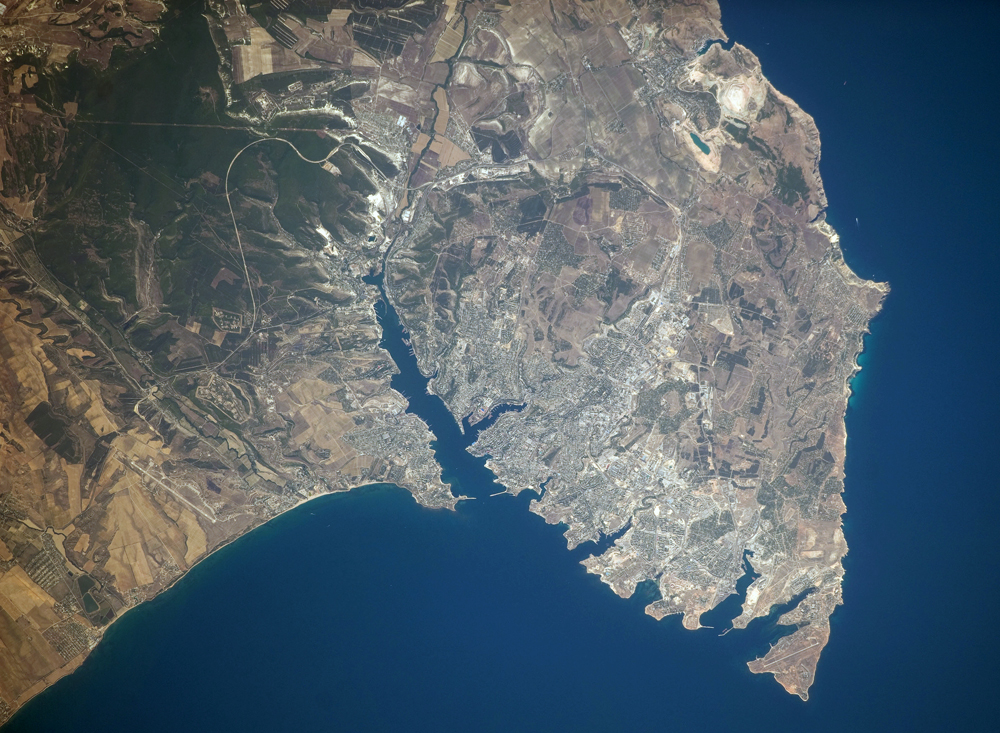
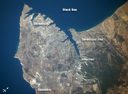
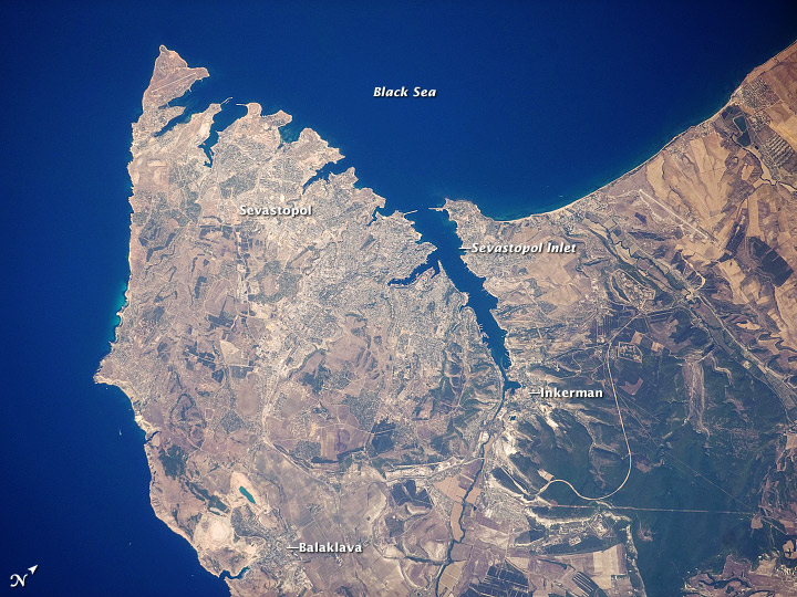
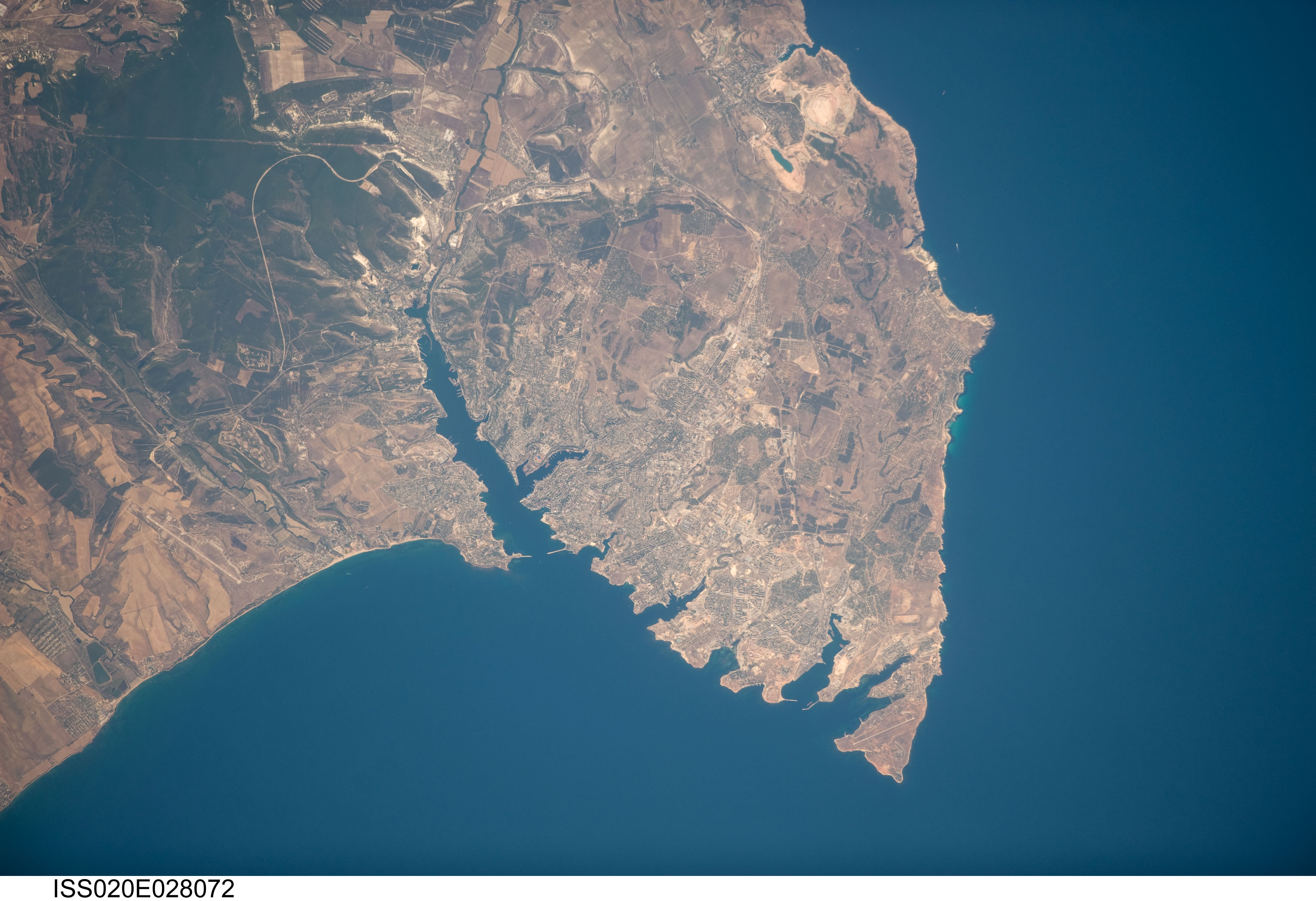
Image Caption: Sevastopol, Ukraine
The port city of Sevastopol is located in southernmost Ukraine on the Crimean Peninsula. The city is an important naval base due to the numerous inlets and bays along the coastline. During the Cold War, the city was the base of the Soviet Black Sea Fleet, but now it services vessels of both the Ukraine and Russia. The main economy of the city is based on trade and shipbuilding, but Sevastopol is also a popular tourist and resort destination for visitors from the Commonwealth of Independent Countries (formed from former Soviet Republics).
This astronaut photograph highlights the jagged coastline of the southern Crimean Peninsula and the various docking areas of Sevastopol. The urban area is light gray, and it is bounded to the north and west by the Black Sea, to the south by vegetated (light green) and fallow (tan) agricultural fields, and to the east by the city of Inkerman and vegetated uplands (deep green). The city of Balaklava, to the south, houses another relic of the Cold War--an underground Soviet submarine base that is now open to the public as a monument. The Chernaya River issues into the Black Sea near Inkerman, flowing into the Sevastopol Inlet to the west.
