ISS020-E-06563
| NASA Photo ID | ISS020-E-06563 |
| Focal Length | 800mm |
| Date taken | 2009.06.03 |
| Time taken | 00:08:06 GMT |
Resolutions offered for this image:
1000 x 665 pixels 540 x 359 pixels 720 x 480 pixels 4256 x 2913 pixels 640 x 438 pixels
1000 x 665 pixels 540 x 359 pixels 720 x 480 pixels 4256 x 2913 pixels 640 x 438 pixels
Cloud masks available for this image:
Spacecraft nadir point: 8.2° S, 119.6° E
Photo center point: 8.3° S, 118.0° E
Photo center point by machine learning:
Photo center point: 8.3° S, 118.0° E
Photo center point by machine learning:
Nadir to Photo Center: West
Spacecraft Altitude: 189 nautical miles (350km)
Country or Geographic Name: | INDONESIA |
Features: | MOUNT TAMBORA, SUMBAWA ISLAND, CALDERA |
| Features Found Using Machine Learning: | |
Cloud Cover Percentage: | 10 (1-10)% |
Sun Elevation Angle: | 26° |
Sun Azimuth: | 60° |
Camera: | Nikon D3 Electronic Still Camera |
Focal Length: | 800mm |
Camera Tilt: | 27 degrees |
Format: | 4256E: 4256 x 2832 pixel CMOS sensor, 36.0mm x 23.9mm, total pixels: 12.87 million, Nikon FX format |
Film Exposure: | |
| Additional Information | |
| Width | Height | Annotated | Cropped | Purpose | Links |
|---|---|---|---|---|---|
| 1000 pixels | 665 pixels | No | Yes | Earth From Space collection | Download Image |
| 540 pixels | 359 pixels | Yes | Yes | Earth From Space collection | Download Image |
| 720 pixels | 480 pixels | Yes | Yes | NASA's Earth Observatory web site | Download Image |
| 4256 pixels | 2913 pixels | No | No | Download Image | |
| 640 pixels | 438 pixels | No | No | Download Image |
Download Packaged File
Download a Google Earth KML for this Image
View photo footprint information
Download a GeoTIFF for this photo
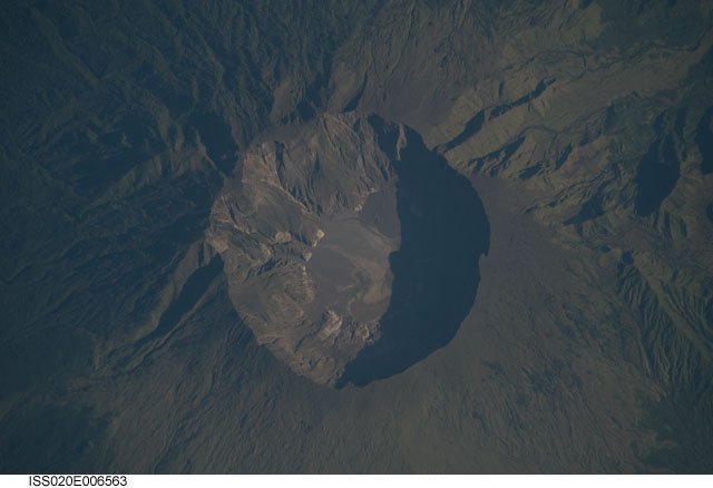
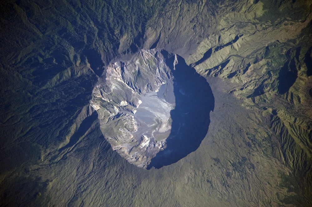
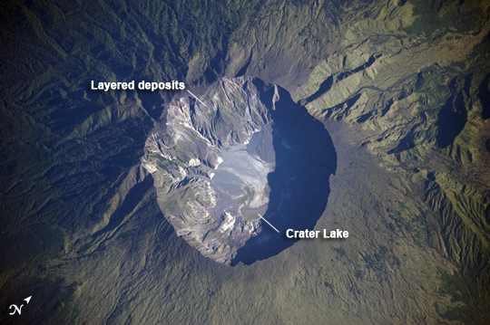
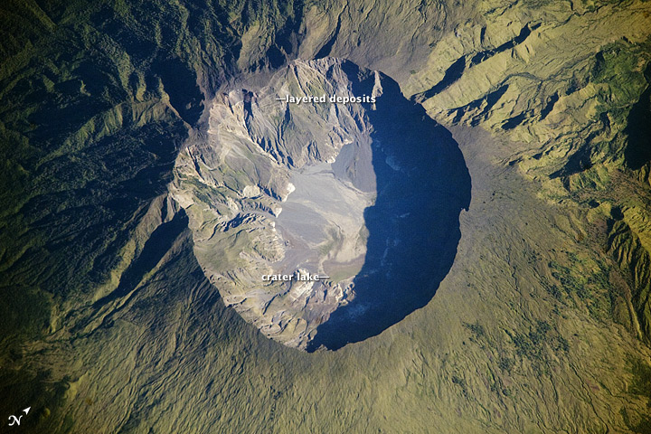
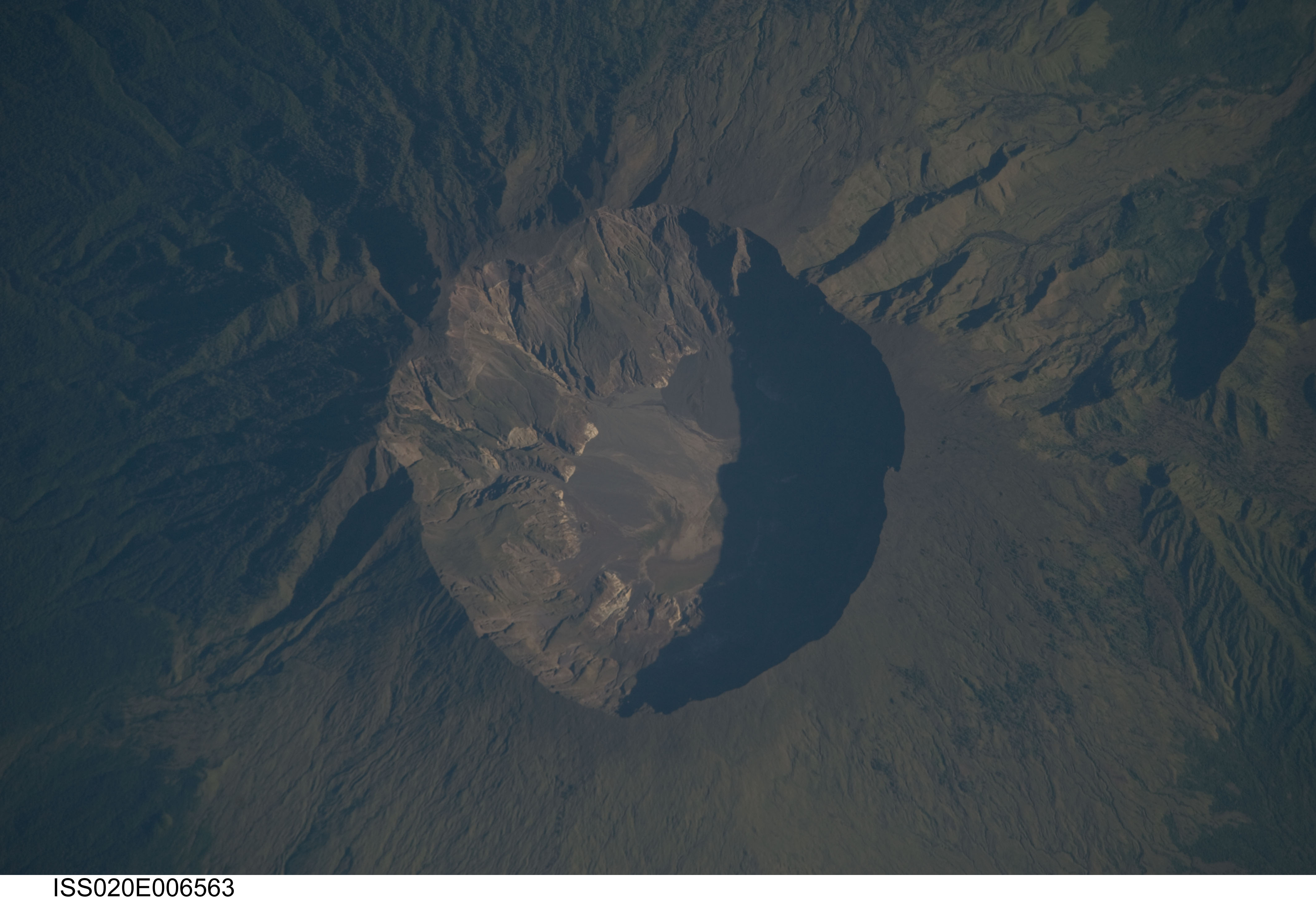
Image Caption: Mount Tambora Volcano, Sumbawa Island, Indonesia
On April 10, 1815, the Tambora Volcano produced the largest eruption in history. An estimated 150 cubic kilometers of tephra--exploded rock and ash--resulted, with ash from the eruption recognized at least 1,300 kilometers away to the northwest. While the April 10 eruption was catastrophic, historical records and geological analysis of eruption deposits indicate that the volcano had been active between 1812 and 1815. Enough ash was put into the atmosphere from the April 10 eruption to reduce incident sunlight on the Earth's surface and cause global cooling, resulting in the 1816 "year without a summer."
This detailed astronaut photograph depicts the summit caldera of the volcano. The huge caldera--6 kilometers in diameter and 1,100 meters deep--formed when Tambora's estimated 4,000-meter-high peak was removed, and the magma chamber below emptied during the April 10 eruption. Today the crater floor is occupied by an ephemeral freshwater lake, recent sedimentary deposits, and minor lava flows and domes emplaced during the nineteenth and twentieth centuries. Layered tephra deposits are visible along the northwestern crater rim. Active fumaroles, or steam vents, still exist in the caldera.
In 2004, scientists discovered the remains of a village, and two adults buried under approximately 3 meters of ash in a gully on Tambora's flank--remnants of the former Kingdom of Tambora preserved by the 1815 eruption that destroyed it. The similarity of the Tambora remains to those associated with the AD 79 eruption of Mount Vesuvius has led to the Tambora site's description as "the Pompeii of the East."
