ISS019-E-5989
| NASA Photo ID | ISS019-E-5989 |
| Focal Length | 800mm |
| Date taken | 2009.04.09 |
| Time taken | 21:18:05 GMT |
Resolutions offered for this image:
1000 x 1515 pixels 540 x 818 pixels 720 x 960 pixels 3072 x 2098 pixels 640 x 437 pixels
1000 x 1515 pixels 540 x 818 pixels 720 x 960 pixels 3072 x 2098 pixels 640 x 437 pixels


Cloud masks available for this image:
Spacecraft nadir point: 46.0° N, 95.4° W
Photo center point: 46.2° N, 96.6° W
Photo center point by machine learning:
Photo center point: 46.2° N, 96.6° W
Photo center point by machine learning:
Nadir to Photo Center: West
Spacecraft Altitude: 188 nautical miles (348km)
Country or Geographic Name: | USA-NORTH DAKOTA |
Features: | WAHPETON-BREKENRIDGE, FLOODING |
| Features Found Using Machine Learning: | |
Cloud Cover Percentage: | 10 (1-10)% |
Sun Elevation Angle: | 37° |
Sun Azimuth: | 239° |
Camera: | Nikon D2Xs Electronic Still Camera |
Focal Length: | 800mm |
Camera Tilt: | 21 degrees |
Format: | 4288E: 4288 x 2848 pixel CMOS sensor, RGBG imager color filter |
Film Exposure: | |
| Additional Information | |
| Width | Height | Annotated | Cropped | Purpose | Links |
|---|---|---|---|---|---|
| 1000 pixels | 1515 pixels | No | Yes | Earth From Space collection | Download Image |
| 540 pixels | 818 pixels | Yes | Yes | Earth From Space collection | Download Image |
| 720 pixels | 960 pixels | Yes | Yes | NASA's Earth Observatory web site | Download Image |
| 3072 pixels | 2098 pixels | No | No | Download Image | |
| 640 pixels | 437 pixels | No | No | Download Image |
Download Packaged File
Download a Google Earth KML for this Image
View photo footprint information
Download a GeoTIFF for this photo
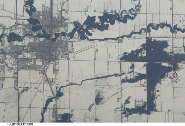
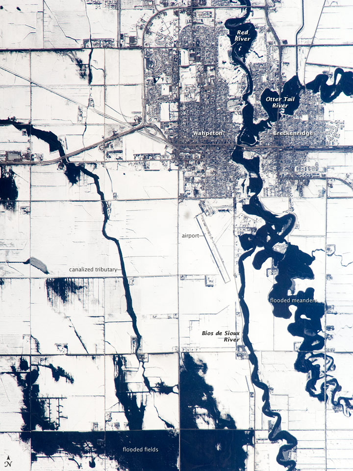
Image Caption: Red River Floods, North Dakota and Minnesota
When this astronaut photo was captured on April 9, 2009, the Red River was experiencing its second round of spring flooding. (Two weeks earlier, the river had crested at very high levels.) The Red River flows north between North Dakota and Minnesota from the confluence of the Bois de Sioux River (south, image lower right) and the less well drained, meandering Otter Tail River (east, image right). Floodwaters in these two tributaries appear as black shapes against a snowy agricultural landscape that is defined by rectangular fields. The largest flooded areas are low parts of fields (image bottom) along a canalized western tributary of the Wild Rice River, which itself becomes a tributary of the Red River just south of Fargo, North Dakota.
Wahpeton, North Dakota, and Breckenridge, Minnesota, sit opposite each another on the banks of the Red River, and their city-block patterns stand out as dark gray patches against the snow at image top right. The main runway of the Henry Stern Airport lies angled northwest directly south of Wahpeton, and its 1.3-kilometers (0.8-mile) runway gives a sense of scale to the photo. Access roads to the agricultural fields tend to follow an orthogonal pattern, while larger roads leading to the cities cut across this pattern (image upper left, near Wahpeton). A subtle pattern of drainage ditches and plow lines appears as thin, parallel lines throughout fields in the scene.
