ISS018-E-43947
| NASA Photo ID | ISS018-E-43947 |
| Focal Length | 50mm |
| Date taken | 2009.03.26 |
| Time taken | 10:21:26 GMT |
Resolutions offered for this image:
1000 x 661 pixels 540 x 360 pixels 720 x 480 pixels 3072 x 2098 pixels 640 x 437 pixels
1000 x 661 pixels 540 x 360 pixels 720 x 480 pixels 3072 x 2098 pixels 640 x 437 pixels


Cloud masks available for this image:
Spacecraft nadir point: 18.6° S, 16.3° E
Photo center point: 18.7° S, 16.5° E
Photo center point by machine learning:
Photo center point: 18.7° S, 16.5° E
Photo center point by machine learning:
Nadir to Photo Center: East
Spacecraft Altitude: 196 nautical miles (363km)
Country or Geographic Name: | NAMIBIA |
Features: | FLOODED ETOSHA PAN, EKUMA R. FLOODS |
| Features Found Using Machine Learning: | |
Cloud Cover Percentage: | 10 (1-10)% |
Sun Elevation Angle: | 67° |
Sun Azimuth: | 26° |
Camera: | Nikon D2Xs Electronic Still Camera |
Focal Length: | 50mm |
Camera Tilt: | 4 degrees |
Format: | 4288E: 4288 x 2848 pixel CMOS sensor, RGBG imager color filter |
Film Exposure: | |
| Additional Information | |
| Width | Height | Annotated | Cropped | Purpose | Links |
|---|---|---|---|---|---|
| 1000 pixels | 661 pixels | No | Yes | Earth From Space collection | Download Image |
| 540 pixels | 360 pixels | Yes | Yes | Earth From Space collection | Download Image |
| 720 pixels | 480 pixels | Yes | Yes | NASA's Earth Observatory web site | Download Image |
| 3072 pixels | 2098 pixels | No | No | Download Image | |
| 640 pixels | 437 pixels | No | No | Download Image |
Download Packaged File
Download a Google Earth KML for this Image
View photo footprint information
Download a GeoTIFF for this photo
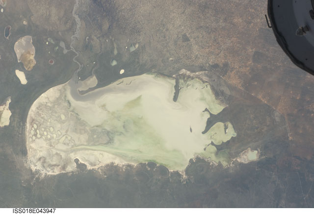
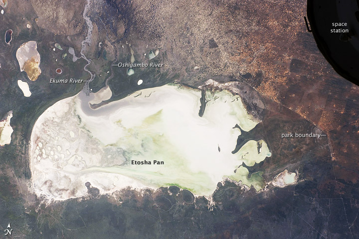
Image Caption: Etosha Pan, Namibia
This International Space Station image from March 26, 2009, shows Namibia's Etosha Pan, which is a large, dry lake about 130 kilometers long. The lake dominates Namibia's Etosha National Park (the sharp edge of the park fence can be seen at image right). Small, related dry lake beds appear as bright shapes at top left, and a portion of the International Space Station appears at image top right.
The pan is the low point in a major inland basin in northern Namibia. During major flood events, such as those experienced in the last nine months, rivers from Angola (the Namibia-Angola boundary lies just outside the top of the image) deliver large quantities of water to the pan. In this image, flood water in the Oshigambo River, resulting from recent heavy rains in Angola, appears as a gray stream entering the northwest corner of the pan (image top left). The floodwater becomes a thin sheet on the vast salt flat of the pan floor. Algae blooms in the warm water have produced a light green tinge. This view shows the pan as it appeared almost ten years ago. Another astronaut image shows the Oshigambo River in flood in 2006.
Reports on the ground combined with satellite imagery acquired after this astronaut photograph indicate that the plains north of the pan are now flooded, and considerable damage to homesteads, crops, and roads has occurred. More than 340,000 people have been affected in northern Namibia and about 250,000 in southern Angola.
