ISS018-E-28898
| NASA Photo ID | ISS018-E-28898 |
| Focal Length | 800mm |
| Date taken | 2009.02.07 |
| Time taken | 15:05:24 GMT |
Resolutions offered for this image:
1000 x 662 pixels 540 x 357 pixels 720 x 480 pixels 3072 x 2098 pixels 640 x 437 pixels
1000 x 662 pixels 540 x 357 pixels 720 x 480 pixels 3072 x 2098 pixels 640 x 437 pixels


Cloud masks available for this image:
Spacecraft nadir point: 19.7° N, 97.5° W
Photo center point: 19.0° N, 98.6° W
Photo center point by machine learning:
Photo center point: 19.0° N, 98.6° W
Photo center point by machine learning:
Nadir to Photo Center: Southwest
Spacecraft Altitude: 189 nautical miles (350km)
Country or Geographic Name: | MEXICO |
Features: | POPOCATEPETL VOLCANO, SUMMIT CRATER |
| Features Found Using Machine Learning: | |
Cloud Cover Percentage: | 10 (1-10)% |
Sun Elevation Angle: | 26° |
Sun Azimuth: | 119° |
Camera: | Nikon D2Xs Electronic Still Camera |
Focal Length: | 800mm |
Camera Tilt: | 22 degrees |
Format: | 4288E: 4288 x 2848 pixel CMOS sensor, RGBG imager color filter |
Film Exposure: | |
| Additional Information | |
| Width | Height | Annotated | Cropped | Purpose | Links |
|---|---|---|---|---|---|
| 1000 pixels | 662 pixels | No | Yes | Earth From Space collection | Download Image |
| 540 pixels | 357 pixels | Yes | Yes | Earth From Space collection | Download Image |
| 720 pixels | 480 pixels | Yes | Yes | NASA's Earth Observatory web site | Download Image |
| 3072 pixels | 2098 pixels | No | No | Download Image | |
| 640 pixels | 437 pixels | No | No | Download Image |
Download Packaged File
Download a Google Earth KML for this Image
View photo footprint information
Download a GeoTIFF for this photo
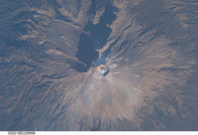
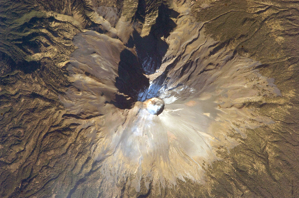
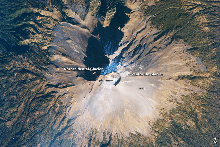
Image Caption: Summit of Popocatepetl Volcano, Mexico
Volcan Popocatepetl, a large stratovolcano located approximately 70 kilometers southeast of Mexico City, is considered by many volcanologists to be "the planet's riskiest volcano." The volcano warrants this distinction because of how close it is to one of the most densely populated megacities on Earth: near 23 million people lived in Mexico City in 2009. The variety of potential volcanic hazards at Popocatepetl is also considerable, including explosive eruptions of ash, pyroclastic flows (hot, fluid avalanches of rock fragments and gas), and debris avalanches.
This detailed astronaut photograph of the summit crater of Popocatepetl (image center) also highlights Ventorillo and Noroccidental Glaciers. Together with the ice on nearby Iztaccihuatl Volcano and Pico de Orizaba (Mexico's highest peak and the highest volcano in North America), Popocatepetl's glaciers are the only mountain glaciers in tropical North America. The glaciers create yet another volcanic hazard: dangerous mudflows, or lahars, if the ice were to melt during an eruption. At the time this image was taken, steam and ash plumes were observed at the volcano. A faint white steam plume is visible against gray ash deposits on the eastern and southern flanks of the volcano.
