ISS018-E-25705
| NASA Photo ID | ISS018-E-25705 |
| Focal Length | 400mm |
| Date taken | 2009.01.30 |
| Time taken | 06:52:03 GMT |
Resolutions offered for this image:
1000 x 1506 pixels 540 x 812 pixels 720 x 540 pixels 3072 x 2098 pixels 640 x 437 pixels
1000 x 1506 pixels 540 x 812 pixels 720 x 540 pixels 3072 x 2098 pixels 640 x 437 pixels

Cloud masks available for this image:
Spacecraft nadir point: 16.4° S, 46.9° E
Photo center point: 16.4° S, 46.6° E
Photo center point by machine learning:
Photo center point: 16.4° S, 46.6° E
Photo center point by machine learning:
Nadir to Photo Center: West
Spacecraft Altitude: 191 nautical miles (354km)
Country or Geographic Name: | MADAGASCAR |
Features: | BETSIBOKA R. |
| Features Found Using Machine Learning: | |
Cloud Cover Percentage: | 10 (1-10)% |
Sun Elevation Angle: | 58° |
Sun Azimuth: | 97° |
Camera: | Nikon D2Xs Electronic Still Camera |
Focal Length: | 400mm |
Camera Tilt: | 5 degrees |
Format: | 4288E: 4288 x 2848 pixel CMOS sensor, RGBG imager color filter |
Film Exposure: | |
| Additional Information | |
| Width | Height | Annotated | Cropped | Purpose | Links |
|---|---|---|---|---|---|
| 1000 pixels | 1506 pixels | No | Yes | Earth From Space collection | Download Image |
| 540 pixels | 812 pixels | Yes | Yes | Earth From Space collection | Download Image |
| 720 pixels | 540 pixels | Yes | Yes | NASA's Earth Observatory web site | Download Image |
| 3072 pixels | 2098 pixels | No | No | Download Image | |
| 640 pixels | 437 pixels | No | No | Download Image |
Download Packaged File
Download a Google Earth KML for this Image
View photo footprint information
Download a GeoTIFF for this photo
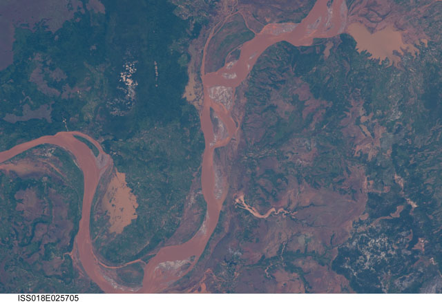
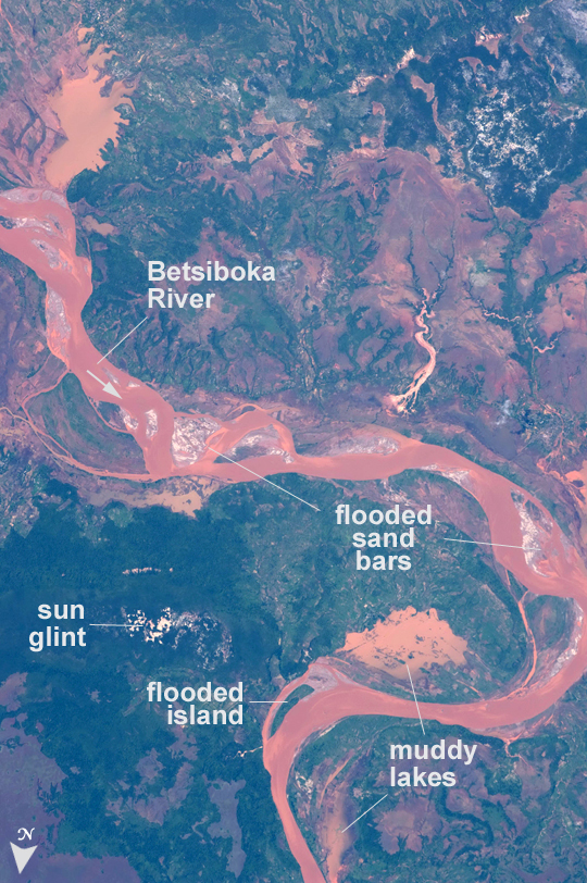
Image Caption: Betsiboka River floods, Madagascar-January 2009
Between January 18 and 20, 2009, Tropical Storm Eric swept along the east coast of the island nation of Madagascar. Rain from this storm fell in the catchment of the Betsiboka River, one of the main rivers in northern Madagascar. In an unlikely coincidence, a larger storm, Cyclone Fanele crossed central Madagascar the next day, on January 21, with its outer bands dropping more rain in the Betsiboka basin. By the time this astronaut image was taken on January 30, the river was flooding all along its length.
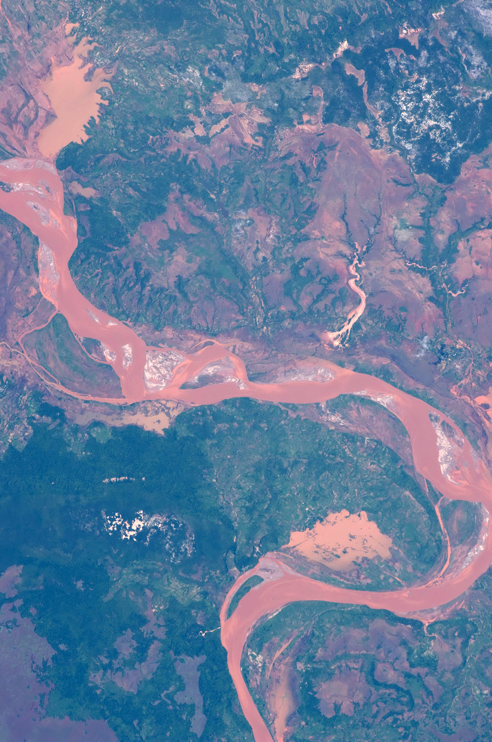
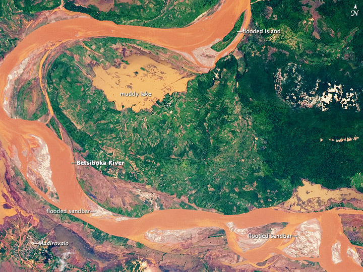
The impact of the flood can be seen by comparing flood conditions (top) with normal flow conditions (bottom) along a reach of the river. The lower image is a mosaic of two astronaut images taken in late 2003. The main visual differences are the redder color of the river water produced by mud from the eroded red soils of the basin and the greener color of the countryside in the 2009 image, which is related to summer greening of the natural forest vegetation.
The most dramatic changes are the greatly increased width of the river, flooded sand bars within the river, islands shrunken by flooding, and enlarged lakes heavily charged with red mud (indicated as a "muddy lake" on the top image). With time, flood-borne mud sinks out of lake water, and lakes become a characteristically grayer hue. Over time the precise location of the river banks has changed, but such changes probably relate to slower, multi-year changes in the river course.
Between January 18 and 20, 2009, Tropical Storm Eric swept along the east coast of the island nation of Madagascar. Rain from this storm fell in the catchment of the Betsiboka River, one of the main rivers in northern Madagascar. In an unlikely coincidence, a larger storm, Cyclone Fanele crossed central Madagascar the next day, on January 21, with its outer bands dropping more rain in the Betsiboka basin. By the time this astronaut image was taken on January 30, the river was flooding all along its length.
The impact of the flood can be seen by comparing flood conditions (top) with normal flow conditions (bottom) along a reach of the river. The lower image is a mosaic of two astronaut images taken in late 2003. The main visual differences are the redder color of the river water produced by mud from the eroded red soils of the basin and the greener color of the countryside in the 2009 image, which is related to summer greening of the natural forest vegetation.
The most dramatic changes are the greatly increased width of the river, flooded sand bars within the river, islands shrunken by flooding, and enlarged lakes heavily charged with red mud (indicated as a "muddy lake" on the top image). With time, flood-borne mud sinks out of lake water, and lakes become a characteristically grayer hue. Over time the precise location of the river banks has changed, but such changes probably relate to slower, multi-year changes in the river course.
