ISS018-E-24949
| NASA Photo ID | ISS018-E-24949 |
| Focal Length | 800mm |
| Date taken | 2009.01.31 |
| Time taken | 19:47:01 GMT |
Resolutions offered for this image:
1000 x 659 pixels 540 x 356 pixels 720 x 480 pixels 3072 x 2098 pixels 640 x 437 pixels
1000 x 659 pixels 540 x 356 pixels 720 x 480 pixels 3072 x 2098 pixels 640 x 437 pixels
Cloud masks available for this image:
Spacecraft nadir point: 32.1° N, 113.2° W
Photo center point: 32.7° N, 114.9° W
Photo center point by machine learning:
Photo center point: 32.7° N, 114.9° W
Photo center point by machine learning:
Nadir to Photo Center: West
Spacecraft Altitude: 189 nautical miles (350km)
Camera: | Nikon D2Xs Electronic Still Camera |
Focal Length: | 800mm |
Camera Tilt: | 30 degrees |
Format: | 4288E: 4288 x 2848 pixel CMOS sensor, RGBG imager color filter |
Film Exposure: | |
| Additional Information | |
| Width | Height | Annotated | Cropped | Purpose | Links |
|---|---|---|---|---|---|
| 1000 pixels | 659 pixels | No | Yes | Earth From Space collection | Download Image |
| 540 pixels | 356 pixels | Yes | Yes | Earth From Space collection | Download Image |
| 720 pixels | 480 pixels | Yes | Yes | NASA's Earth Observatory web site | Download Image |
| 3072 pixels | 2098 pixels | No | No | Download Image | |
| 640 pixels | 437 pixels | No | No | Download Image |
Download Packaged File
Download a Google Earth KML for this Image
View photo footprint information
Download a GeoTIFF for this photo
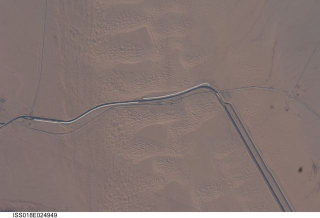
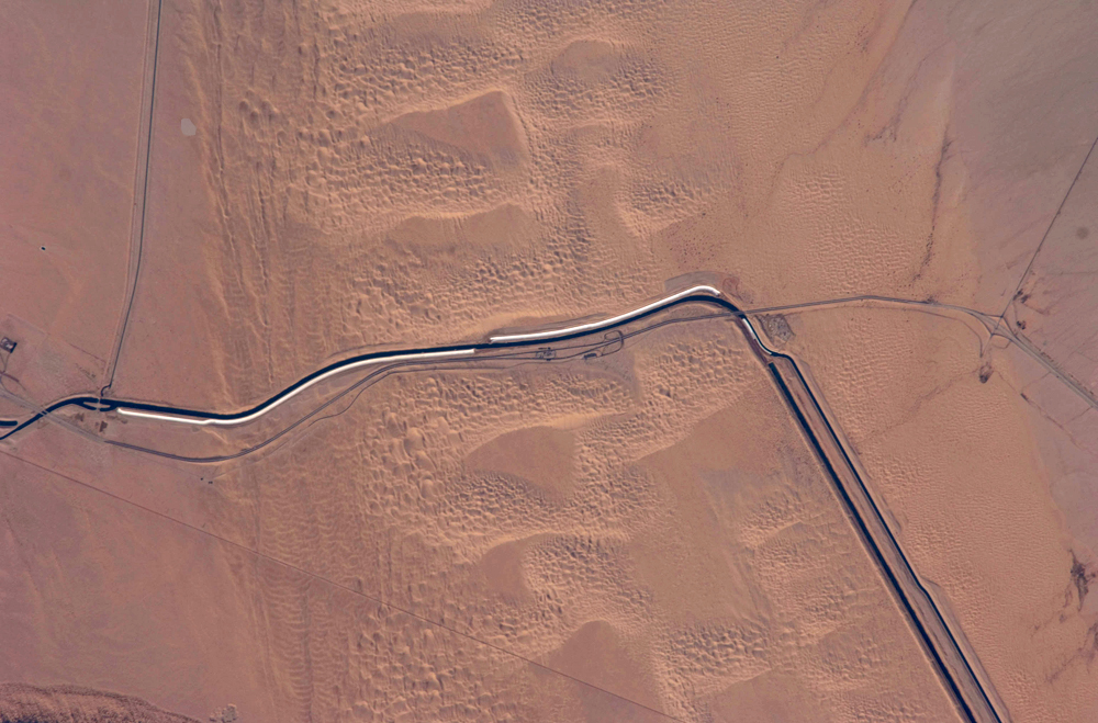
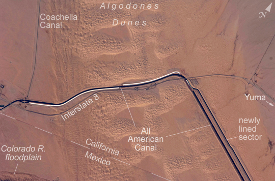
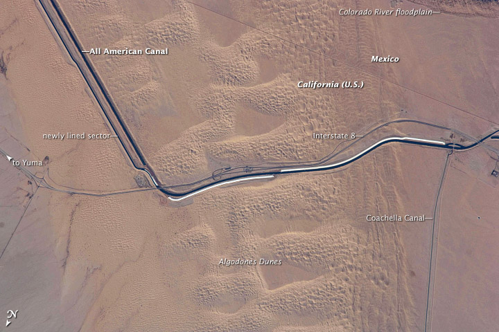
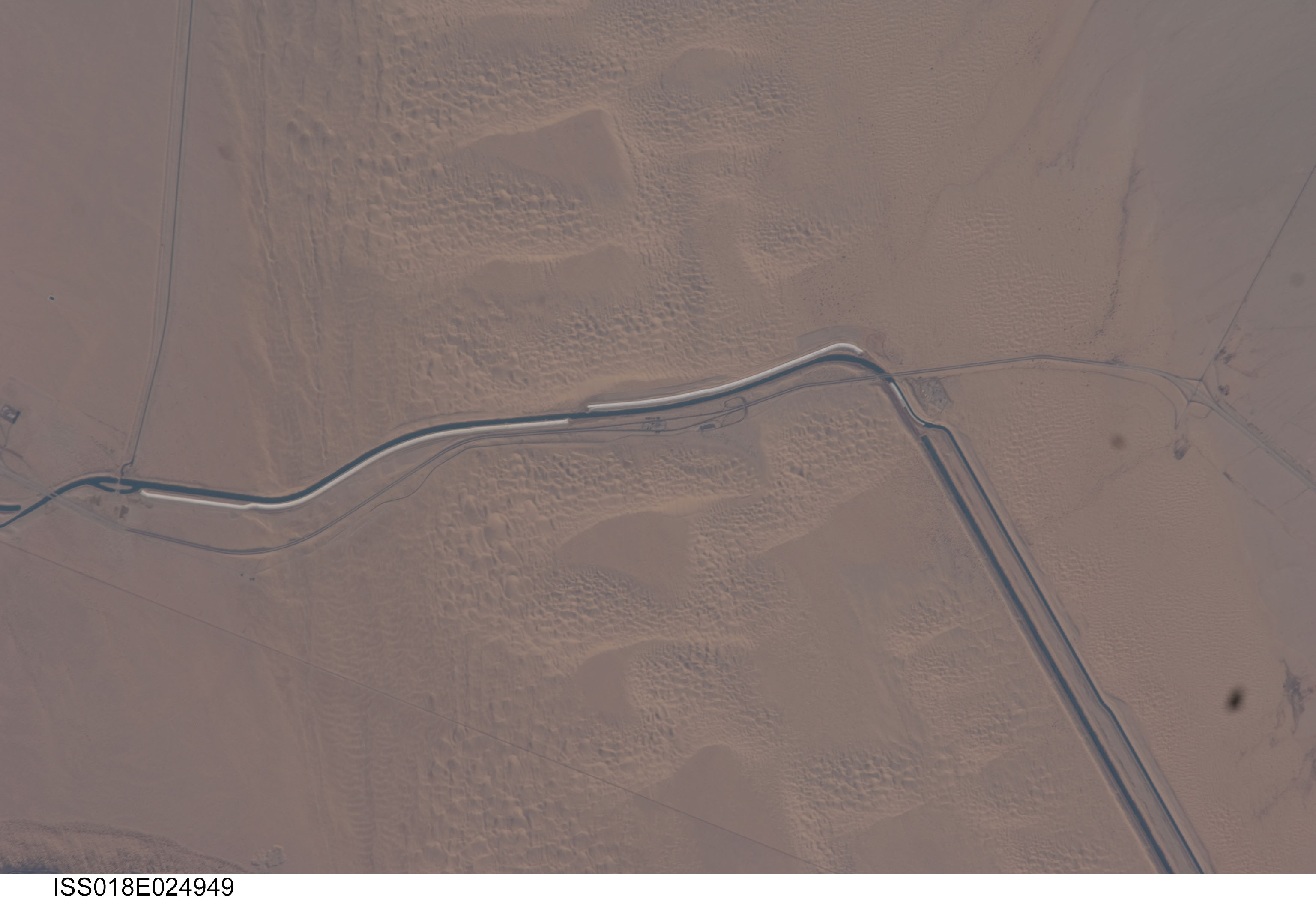
Image Caption: All American Canal, California-Mexico border
The All-American Canal, the largest irrigation canal in the world and a key landmark along the US-Mexico border, shows up in this astronaut photograph. This image captures about 15 km of the important infrastructure corridor just west of Yuma, AZ. The prominent dark line crossing the image is the Canal which is crossed, in this view, by Interstate Highway 8. The canal carries 740.6 cubic meters (26,155 cubic feet) of water per second from the Colorado River westward to support the intensive agriculture of California's Imperial Valley to the northwest, and to nine cities including San Diego, CA. The canal system is the Imperial Valley's only source of water, and allows irrigation of more than 2,000 square kilometers (500,000 acres) of agricultural fields. The Coachella Canal, one of four main branch canals off of the All-American, leads water north to Imperial Valley.
This section of the canal requires constant maintenance. Approximately 68,000 acre-feet of water per year are lost by seepage from the All American Canal - especially where the canal crosses the great Algodones Dune Field, a portion of which is visible extending from top to bottom in the center of the image. Additionally, dune sand is constantly blown to the southeast, and into the canal. As part of California's Colorado River Water Use Plan, 37 km (23 miles) of the canal is being lined to prevent water loss by seepage. A recently opened sector parallels the old canal (image right) and new lined sectors are under construction (bright lines, center). Engineers have sited new sections of the canal to avoid the worst areas of dune-sand invasion, so that the new configuration will be significantly cheaper to maintain and operate.
A new road--unseen in prior imagery--crosses the dunes at image lower left and marks the US-Mexico border as part of border fence construction efforts. The margin of the Colorado River floodplain in Mexico is just visible 2 km south of the border (image lower left corner). This floodplain is Mexico's equivalent of the Imperial Valley in terms of its enormous irrigated agricultural production.
