ISS018-E-11096
| NASA Photo ID | ISS018-E-11096 |
| Focal Length | 800mm |
| Date taken | 2008.12.06 |
| Time taken | 19:12:52 GMT |
Resolutions offered for this image:
1000 x 664 pixels 540 x 359 pixels 720 x 480 pixels 3072 x 2098 pixels 640 x 437 pixels
1000 x 664 pixels 540 x 359 pixels 720 x 480 pixels 3072 x 2098 pixels 640 x 437 pixels
Cloud masks available for this image:
Spacecraft nadir point: 34.8° N, 119.3° W
Photo center point: 34.4° N, 119.7° W
Photo center point by machine learning:
Photo center point: 34.4° N, 119.7° W
Photo center point by machine learning:
Nadir to Photo Center: Southwest
Spacecraft Altitude: 186 nautical miles (344km)
Country or Geographic Name: | USA-CALIFORNIA |
Features: | SANTA BARBARA, SANTA YNEZ MTS |
| Features Found Using Machine Learning: | |
Cloud Cover Percentage: | 10 (1-10)% |
Sun Elevation Angle: | 32° |
Sun Azimuth: | 170° |
Camera: | Nikon D2Xs Electronic Still Camera |
Focal Length: | 800mm |
Camera Tilt: | 10 degrees |
Format: | 4288E: 4288 x 2848 pixel CMOS sensor, RGBG imager color filter |
Film Exposure: | |
| Additional Information | |
| Width | Height | Annotated | Cropped | Purpose | Links |
|---|---|---|---|---|---|
| 1000 pixels | 664 pixels | No | Yes | Earth From Space collection | Download Image |
| 540 pixels | 359 pixels | Yes | Yes | Earth From Space collection | Download Image |
| 720 pixels | 480 pixels | Yes | Yes | NASA's Earth Observatory web site | Download Image |
| 3072 pixels | 2098 pixels | No | No | Download Image | |
| 640 pixels | 437 pixels | No | No | Download Image |
Download Packaged File
Download a Google Earth KML for this Image
View photo footprint information
Download a GeoTIFF for this photo
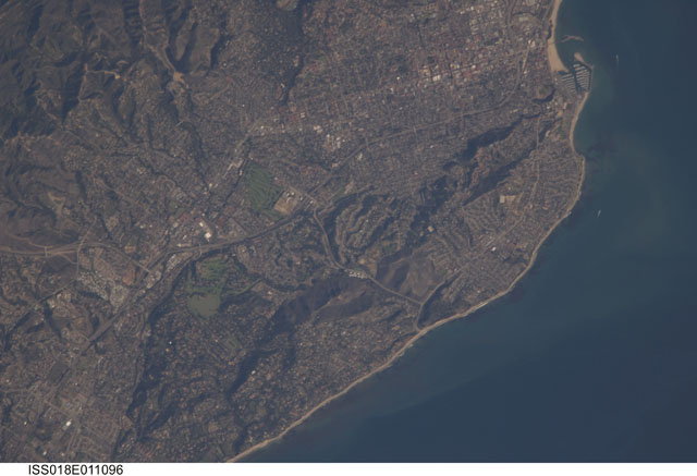
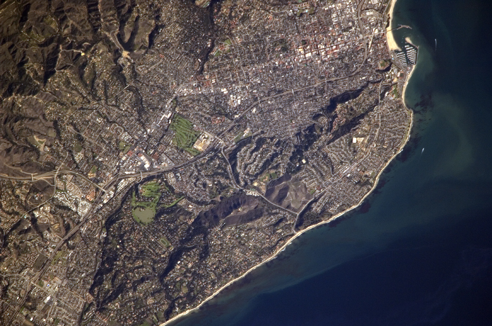
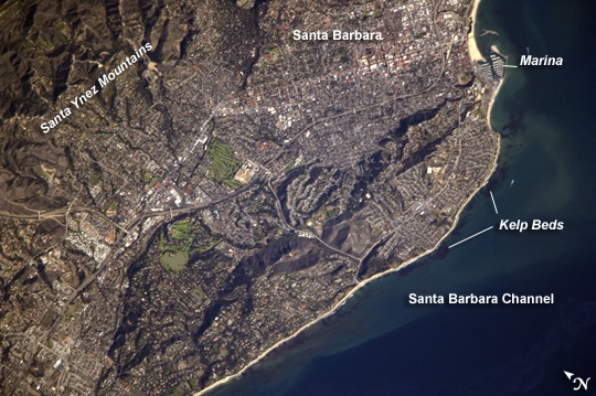
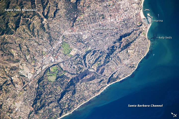
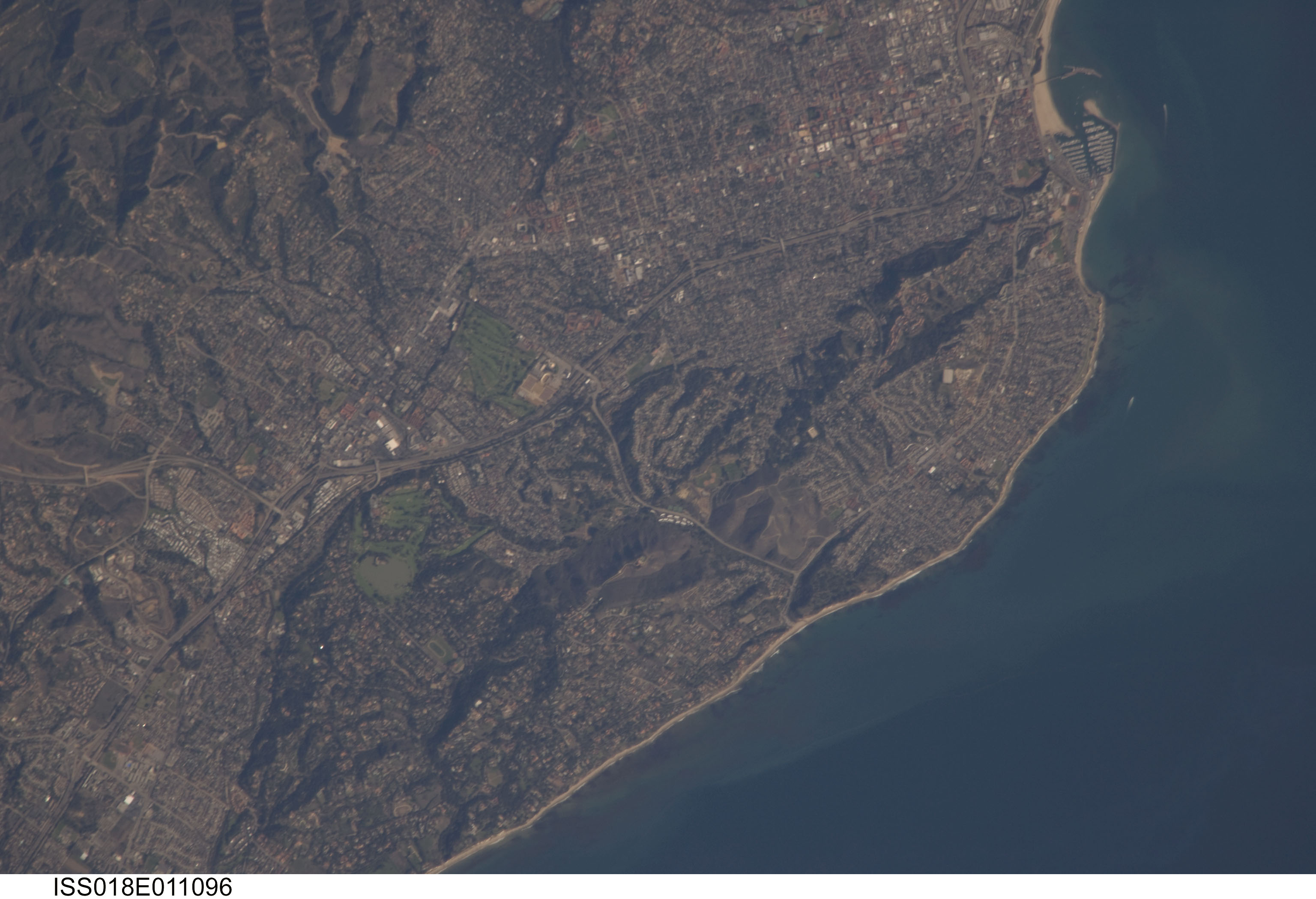
Image Caption: Santa Barbara, CA
This detailed astronaut photograph highlights the Santa Barbara, California, metropolitan area, sometimes called the "American Riviera." The geographic setting of the city--between the Santa Barbara Channel to the south and the steep Santa Ynez Mountains to the north--and its year-round mild climate evoke the Mediterranean Riviera. The city was officially founded as a Spanish mission in 1786, and it was incorporated into the United States from Mexico in 1848 following the Mexican-American War.
The dramatic landscape of the city is the result of tectonic forces; the Santa Barbara Channel is part of the boundary between the oceanic Pacific Plate and the continental North American Plate. Movement along the San Andreas Fault--the actual zone of contact between the two plates--over geologic time both raised the Santa Ynez range and lowered the seafloor, forming the deep Santa Barbara Channel. The city has experienced two earthquakes, one in 1812 and another in 1925, that caused significant damage.
The urban street grid is defined by white and red rooftops at image top center; to the southeast lie beaches and the boat slips of a large marina (image top right). Two large golf courses, characterized by expanses of green grass, are visible at image center. Low, east-west-trending hills that parallel the coastline are almost completely covered by residential and commercial development, lending a speckled appearance to the hillsides. Immediately offshore, giant kelp beds are the focus of the Santa Barbara Coastal Long Term Ecological Research site, part of the National Science Foundation's Long Term Ecological Research Network.
