ISS017-E-9598
| NASA Photo ID | ISS017-E-9598 |
| Focal Length | 400mm |
| Date taken | 2008.06.18 |
| Time taken | 16:22:59 GMT |
Resolutions offered for this image:
1000 x 664 pixels 540 x 359 pixels 540 x 405 pixels 3072 x 2098 pixels 640 x 437 pixels
1000 x 664 pixels 540 x 359 pixels 540 x 405 pixels 3072 x 2098 pixels 640 x 437 pixels


Cloud masks available for this image:
Spacecraft nadir point: 33.4° N, 113.1° W
Photo center point: 33.0° N, 113.1° W
Photo center point by machine learning:
Photo center point: 33.0° N, 113.1° W
Photo center point by machine learning:
Nadir to Photo Center: South
Spacecraft Altitude: 180 nautical miles (333km)
Country or Geographic Name: | USA-ARIZONA |
Features: | SENTINEL PLAIN, OATMAN MTN. |
| Features Found Using Machine Learning: | |
Cloud Cover Percentage: | 10 (1-10)% |
Sun Elevation Angle: | 47° |
Sun Azimuth: | 91° |
Camera: | Nikon D2Xs Electronic Still Camera |
Focal Length: | 400mm |
Camera Tilt: | 8 degrees |
Format: | 4288E: 4288 x 2848 pixel CMOS sensor, RGBG imager color filter |
Film Exposure: | |
| Additional Information | |
| Width | Height | Annotated | Cropped | Purpose | Links |
|---|---|---|---|---|---|
| 1000 pixels | 664 pixels | No | Yes | Earth From Space collection | Download Image |
| 540 pixels | 359 pixels | Yes | Yes | Earth From Space collection | Download Image |
| 540 pixels | 405 pixels | Yes | Yes | NASA's Earth Observatory web site | Download Image |
| 3072 pixels | 2098 pixels | No | No | Download Image | |
| 640 pixels | 437 pixels | No | No | Download Image |
Download Packaged File
Download a Google Earth KML for this Image
View photo footprint information
Download a GeoTIFF for this photo
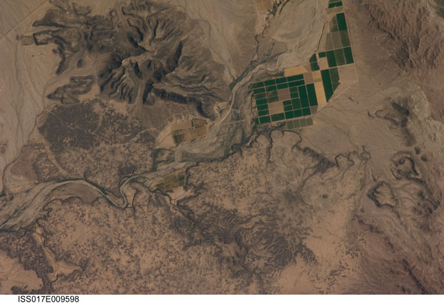
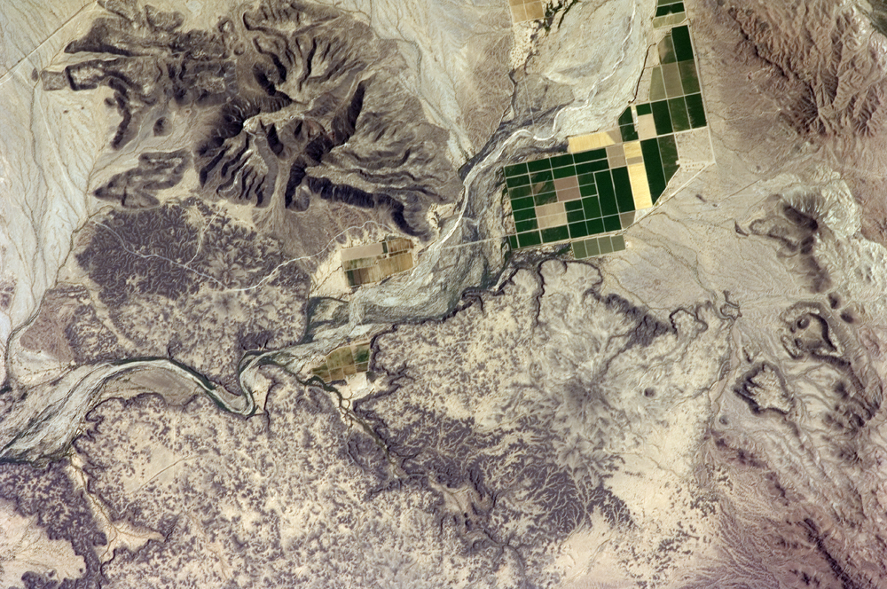
Image Caption: Sentinel Volcanic Field, Arizona
This detailed astronaut photograph depicts a portion of the Gila River channel (image center) between the Sentinel Volcanic Field and Oatman Mountain in south-central Arizona. The northernmost boundary of the Sentinel field is visible in the image, recognizable by the irregular flow fronts, or leading edge, of thin basalt lava flows erupted from low volcanic cones approximately 3.3-1.3 million years ago. The lava flow tops range in color from dark brown exposed rock to a tan, carbonate-rich soil cover. Active agricultural fields along the Gila River are a rich green set against the surrounding desert.
In contrast to the gentle topography of the Sentinel Volcanic Field, Oatman Mountain (upper left) rises from the Gila River channel to an elevation of approximately 560 meters (1,837 feet). While Oatman Mountain is located close to the Sentinel field, it represents an earlier phase of volcanic activity in the area. Volcanic rocks comprising Oatman Mountain were more viscous, leading to shorter, stronger flows that are weathered into stream channels and scarps on the mountain slopes. The mountain is a popular hang gliding destination due to abundant thermal currents rising from the surrounding desert floor and lava surfaces.
