ISS017-E-8285

| NASA Photo ID | ISS017-E-8285 |
| Focal Length | 800mm |
| Date taken | 2008.05.30 |
| Time taken | 14:32:08 GMT |
Resolutions offered for this image:
1000 x 687 pixels 540 x 371 pixels 540 x 540 pixels 3072 x 2098 pixels 639 x 437 pixels
1000 x 687 pixels 540 x 371 pixels 540 x 540 pixels 3072 x 2098 pixels 639 x 437 pixels

Cloud masks available for this image:
Spacecraft nadir point: 32.0° N, 30.0° E
Photo center point: 29.8° N, 31.2° E
Photo center point by machine learning:
Photo center point: 29.8° N, 31.2° E
Photo center point by machine learning:
Nadir to Photo Center: Southeast
Spacecraft Altitude: 182 nautical miles (337km)
Country or Geographic Name: | EGYPT |
Features: | PYRAMIDS, DAHSHUR, NILE R. V. |
| Features Found Using Machine Learning: | |
Cloud Cover Percentage: | 10 (1-10)% |
Sun Elevation Angle: | 29° |
Sun Azimuth: | 279° |
Camera: | Nikon D2Xs Electronic Still Camera |
Focal Length: | 800mm |
Camera Tilt: | 40 degrees |
Format: | 4288E: 4288 x 2848 pixel CMOS sensor, RGBG imager color filter |
Film Exposure: | |
| Additional Information | |
| Width | Height | Annotated | Cropped | Purpose | Links |
|---|---|---|---|---|---|
| 1000 pixels | 687 pixels | No | Yes | Earth From Space collection | Download Image |
| 540 pixels | 371 pixels | Yes | Yes | Earth From Space collection | Download Image |
| 540 pixels | 540 pixels | Yes | Yes | NASA's Earth Observatory web site | Download Image |
| 3072 pixels | 2098 pixels | No | No | Download Image | |
| 639 pixels | 437 pixels | No | No | Download Image |
Download Packaged File
Download a Google Earth KML for this Image
View photo footprint information
Download a GeoTIFF for this photo
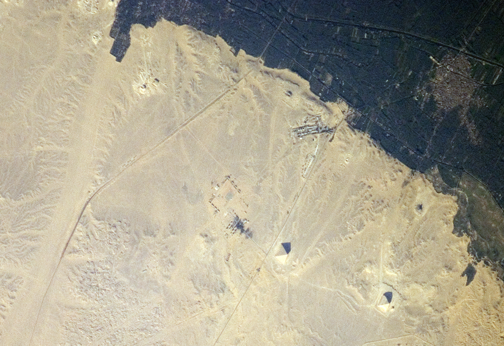
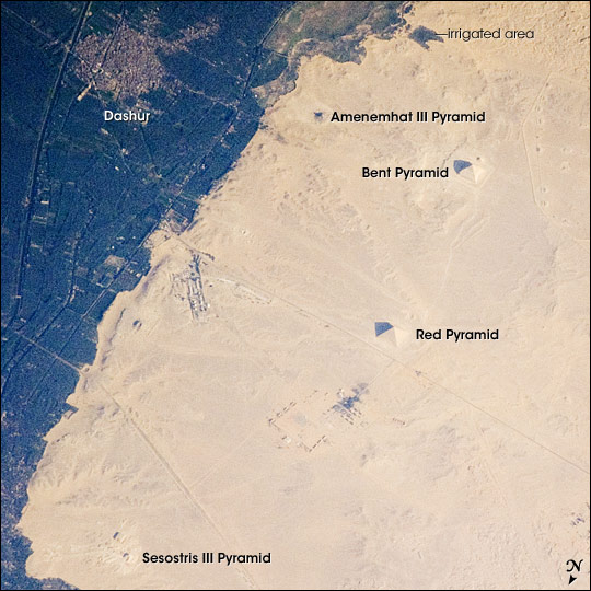
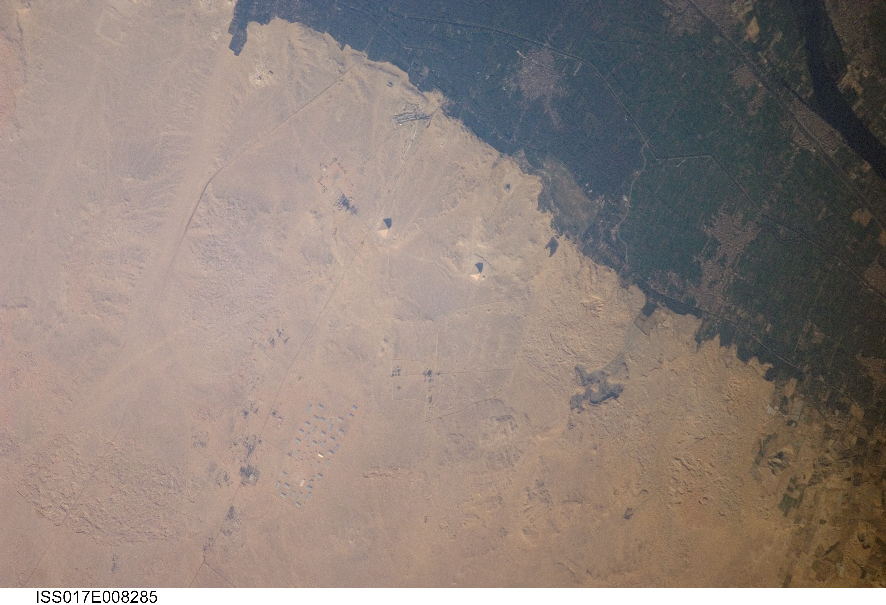
Image Caption: Pyramids of Dashur, Egypt
While the pyramids of Giza are perhaps the most famous, there are several other ancient Egyptian royal necropolis ("city of the dead") sites situated along the Nile River and its delta. One of these sites is near the village of Dashur, illustrated in this astronaut photograph. The gray-brown built area of Dashur is surrounded by green agricultural land of the Nile Delta, which forms a distinct boundary with the tan desert to the west. It is in the desert that the monuments of the ancient rulers of Egypt are found.
Several monuments are visible in this image, including the large Red and Bent Pyramids built by Snofru, first king of the Fourth Dynasty, which lasted from 2575-2465 BC. Other visible monuments include the pyramid complexes of Amenemhat III and Sesostris III, both kings of the Twelfth Dynasty (1991-1783 BC). Both of these complexes are poorly preserved, due to both the unstable ground conditions and the dismantling of the limestone blocks forming the outer pyramid casings during later historical periods.
The Bent Pyramid (image upper right) is so called because the slope of the outer face was lessened halfway through construction, leading to a distinctive "bent" profile. Scholars have offered different explanations for why this was done: perhaps to decrease the mass of the pyramid to prevent its collapse or to reduce the work necessary to complete it. The Red Pyramid to the north (image center) was built after the Bent Pyramid, and is named for the coloration of the building stone at the structure's core. Compare the shadows of the Red and Bent pyramids in the image to see the different profiles of the structures (easier to see in the large image.) An irregular, dark feature to the southeast of the Bent Pyramid is not a shadow cast by a monument; it is an irrigation area extending into the desert.
