ISS017-E-8188
| NASA Photo ID | ISS017-E-8188 |
| Focal Length | 800mm |
| Date taken | 2008.05.29 |
| Time taken | 21:45:18 GMT |
Resolutions offered for this image:
1000 x 734 pixels 540 x 396 pixels 540 x 405 pixels 3072 x 2098 pixels 639 x 437 pixels
1000 x 734 pixels 540 x 396 pixels 540 x 405 pixels 3072 x 2098 pixels 639 x 437 pixels

Cloud masks available for this image:
Spacecraft nadir point: 24.1° N, 82.9° W
Photo center point: 24.6° N, 82.9° W
Photo center point by machine learning:
Photo center point: 24.6° N, 82.9° W
Photo center point by machine learning:
Nadir to Photo Center: North
Spacecraft Altitude: 183 nautical miles (339km)
Country or Geographic Name: | USA-FLORIDA |
Features: | DRY TORTUGAS, FT. JEFFERSON |
| Features Found Using Machine Learning: | |
Cloud Cover Percentage: | 10 (1-10)% |
Sun Elevation Angle: | 31° |
Sun Azimuth: | 282° |
Camera: | Nikon D2Xs Electronic Still Camera |
Focal Length: | 800mm |
Camera Tilt: | 9 degrees |
Format: | 4288E: 4288 x 2848 pixel CMOS sensor, RGBG imager color filter |
Film Exposure: | |
| Additional Information | |
| Width | Height | Annotated | Cropped | Purpose | Links |
|---|---|---|---|---|---|
| 1000 pixels | 734 pixels | No | Yes | Earth From Space collection | Download Image |
| 540 pixels | 396 pixels | Yes | Yes | Earth From Space collection | Download Image |
| 540 pixels | 405 pixels | Yes | Yes | NASA's Earth Observatory web site | Download Image |
| 3072 pixels | 2098 pixels | No | No | Download Image | |
| 639 pixels | 437 pixels | No | No | Download Image |
Download Packaged File
Download a Google Earth KML for this Image
View photo footprint information
Download a GeoTIFF for this photo
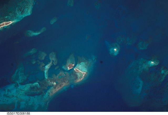
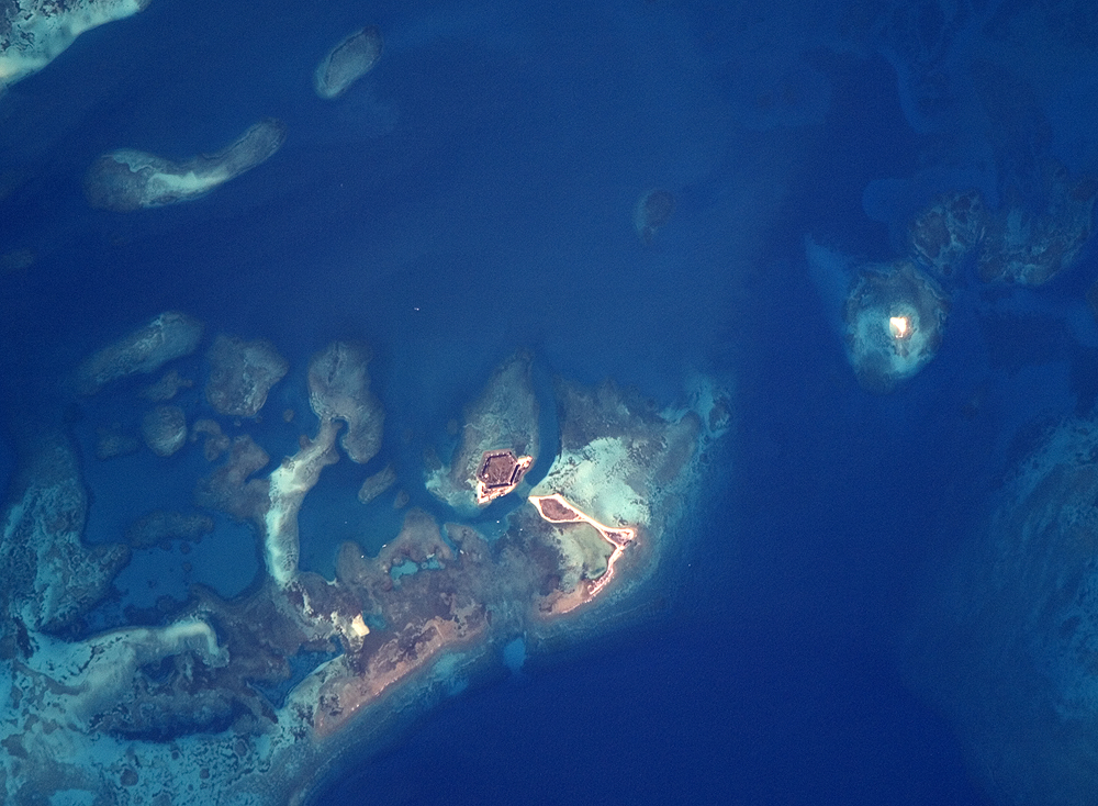
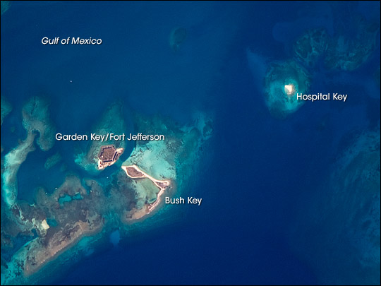
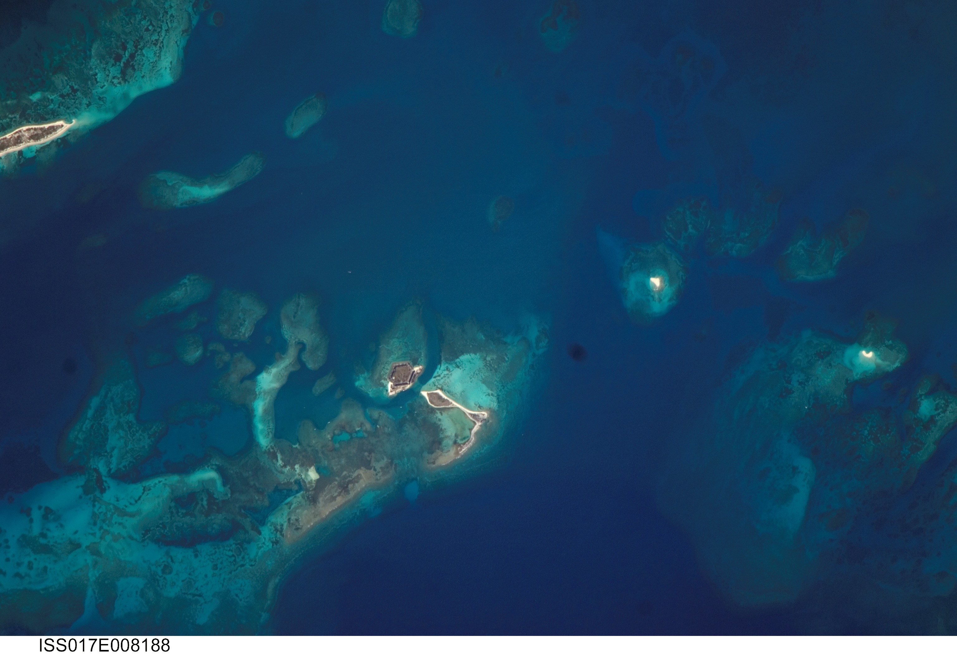
Image Caption: Dry Tortugas, Florida
The Dry Tortugas are a group of islands located approximately 75 miles west of Key West, Florida; they form the western end of the Florida Keys in the Gulf of Mexico. Like the Keys, the Dry Tortugas are formed primarily of coral reefs that overlie older limestone formations. The islands became known to Europeans as the "Dry Tortugas" upon discovery by Ponce de Leon in 1513. Tortugas means "turtles" in Spanish, and the islands are "dry," as no fresh water is found on them. From the air, the islands present an atoll-like arrangement, however no central volcanic structure is present. The islands are only accessible by boat or seaplane; they have been designated the Dry Tortugas National Park.
This astronaut photograph highlights three islands in the group: Bush Key, Hospital Key, and Garden Key, which is the site of Fort Jefferson. Fort Jefferson is a Civil War-era fort, perhaps most notable for being the prison of Dr. Samuel Mudd, who set the broken leg of John Wilkes Booth following Booth's assassination of President Lincoln. The fort itself is currently undergoing extensive restoration to prevent collapse of the hexagonal outer walls (image left). The islands stand out due to brown and light tan carbonate sands visible above the Gulf of Mexico water surface. Light blue-green irregular masses in the image surrounding the islands are coral reef tops visible below the water surface.
