ISS017-E-5763
| NASA Photo ID | ISS017-E-5763 |
| Focal Length | 180mm |
| Date taken | 2008.04.29 |
| Time taken | 19:28:03 GMT |
Resolutions offered for this image:
1000 x 691 pixels 540 x 373 pixels 540 x 405 pixels 3032 x 2064 pixels 639 x 435 pixels
1000 x 691 pixels 540 x 373 pixels 540 x 405 pixels 3032 x 2064 pixels 639 x 435 pixels


Cloud masks available for this image:
Spacecraft nadir point: 30.7° N, 92.2° W
Photo center point: 30.0° N, 90.0° W
Photo center point by machine learning:
Photo center point: 30.0° N, 90.0° W
Photo center point by machine learning:
Nadir to Photo Center: East
Spacecraft Altitude: 180 nautical miles (333km)
Country or Geographic Name: | USA-LOUISIANA |
Features: | L. PONCHARTRAIN, SED. PLUME |
| Features Found Using Machine Learning: | NEW ORLEANS |
Cloud Cover Percentage: | 10 (1-10)% |
Sun Elevation Angle: | 66° |
Sun Azimuth: | 235° |
Camera: | Kodak DCS760c Electronic Still Camera |
Focal Length: | 180mm |
Camera Tilt: | 38 degrees |
Format: | 3060E: 3060 x 2036 pixel CCD, RGBG array |
Film Exposure: | |
| Additional Information | |
| Width | Height | Annotated | Cropped | Purpose | Links |
|---|---|---|---|---|---|
| 1000 pixels | 691 pixels | No | Yes | Earth From Space collection | Download Image |
| 540 pixels | 373 pixels | Yes | Yes | Earth From Space collection | Download Image |
| 540 pixels | 405 pixels | Yes | Yes | NASA's Earth Observatory web site | Download Image |
| 3032 pixels | 2064 pixels | No | No | Download Image | |
| 639 pixels | 435 pixels | No | No | Download Image |
Download Packaged File
Download a Google Earth KML for this Image
View photo footprint information
Download a GeoTIFF for this photo
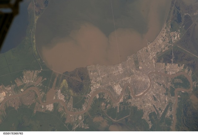
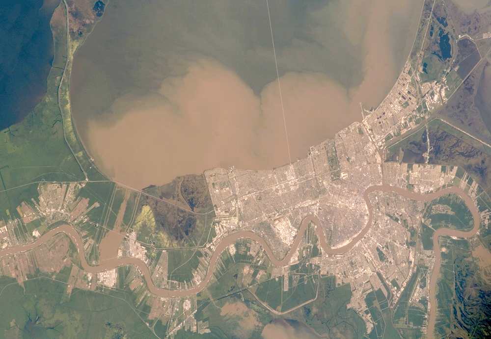
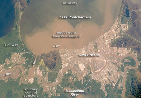
Image Caption: Lake Pontchartrain and the Bonnet Carre Spillway, Louisiana, USA
Lake Pontchartrain, a big body of water immediately north of New Orleans, occupies the upper part of this astronaut photograph, with the winding course of the muddy Mississippi River snaking across the bottom of the view (flow is east, from left to right). The city of New Orleans is sandwiched between the lake and river.
Heavy rain in March and April 2008 in the Mississippi's catchment area raised water levels in the river sufficiently to make the Army Corps of Engineers take action. To reduce the volume of the river where it passes through New Orleans, the Corps opened the Bonnet Carre Spillway (lower left), a major engineering structure 18 km upriver from New Orleans. The spillway, a 1.6 km-wide gap in the developments along the Mississippi levees, is an integral part of the river and canal system that allows Mississippi river water to flow into Lake Pontchartrain. The spillway control structure itself is visible as a thin, discontinuous, white line along the river's edge in this image.
The spillway has only been opened eight times since 1937. News of the opening in April 2008 was transmitted to astronauts aboard the International Space Station who managed to capture the immediate effect of muddy water flowing down the spillway and into Lake Pontchartrain, where it forms great brown lobes in the otherwise green water. These lobes moved slowly east along the New Orleans shoreline, where the line of the Lake Pontchartrain Causeway, the longest bridge in the U.S., can be seen, top right.
Opening the spillway protects New Orleans in various ways. First, it reduces pressure on the levees, which famously collapsed at some points during the onslaught of Hurricane Katrina in 2005. Keeping water levels below critical high levels also helps the river channel to accommodate the discharge of water, and reduces both the speed of flow and cross currents in the river which can interfere with vessels navigating the river - or even cause collisions with levees.
