ISS017-E-16521

| NASA Photo ID | ISS017-E-16521 |
| Focal Length | 800mm |
| Date taken | 2008.09.15 |
| Time taken | 21:33:25 GMT |
Resolutions offered for this image:
1000 x 664 pixels 540 x 359 pixels 540 x 405 pixels 3072 x 2098 pixels 640 x 437 pixels
1000 x 664 pixels 540 x 359 pixels 540 x 405 pixels 3072 x 2098 pixels 640 x 437 pixels
Cloud masks available for this image:
Spacecraft nadir point: 25.6° S, 154.7° E
Photo center point: 24.7° S, 153.2° E
Photo center point by machine learning:
Photo center point: 24.7° S, 153.2° E
Photo center point by machine learning:
Nadir to Photo Center: Northwest
Spacecraft Altitude: 193 nautical miles (357km)
Country or Geographic Name: | AUSTRALIA-Q |
Features: | FRASER ISLAND, SANDY CAPE, DUNES |
| Features Found Using Machine Learning: | |
Cloud Cover Percentage: | 10 (1-10)% |
Sun Elevation Angle: | 25° |
Sun Azimuth: | 74° |
Camera: | Nikon D2Xs Electronic Still Camera |
Focal Length: | 800mm |
Camera Tilt: | 29 degrees |
Format: | 4288E: 4288 x 2848 pixel CMOS sensor, RGBG imager color filter |
Film Exposure: | |
| Additional Information | |
| Width | Height | Annotated | Cropped | Purpose | Links |
|---|---|---|---|---|---|
| 1000 pixels | 664 pixels | No | Yes | Earth From Space collection | Download Image |
| 540 pixels | 359 pixels | Yes | Yes | Earth From Space collection | Download Image |
| 540 pixels | 405 pixels | Yes | Yes | NASA's Earth Observatory web site | Download Image |
| 3072 pixels | 2098 pixels | No | No | Download Image | |
| 640 pixels | 437 pixels | No | No | Download Image |
Download Packaged File
Download a Google Earth KML for this Image
View photo footprint information
Download a GeoTIFF for this photo
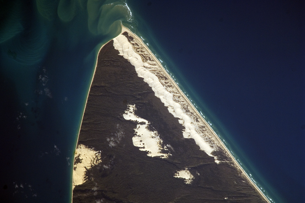
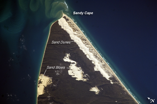
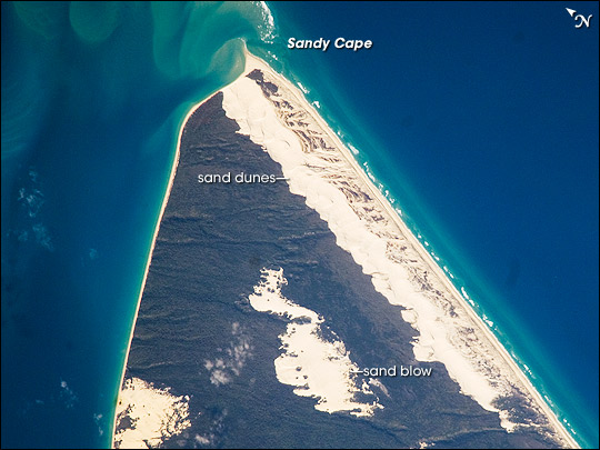
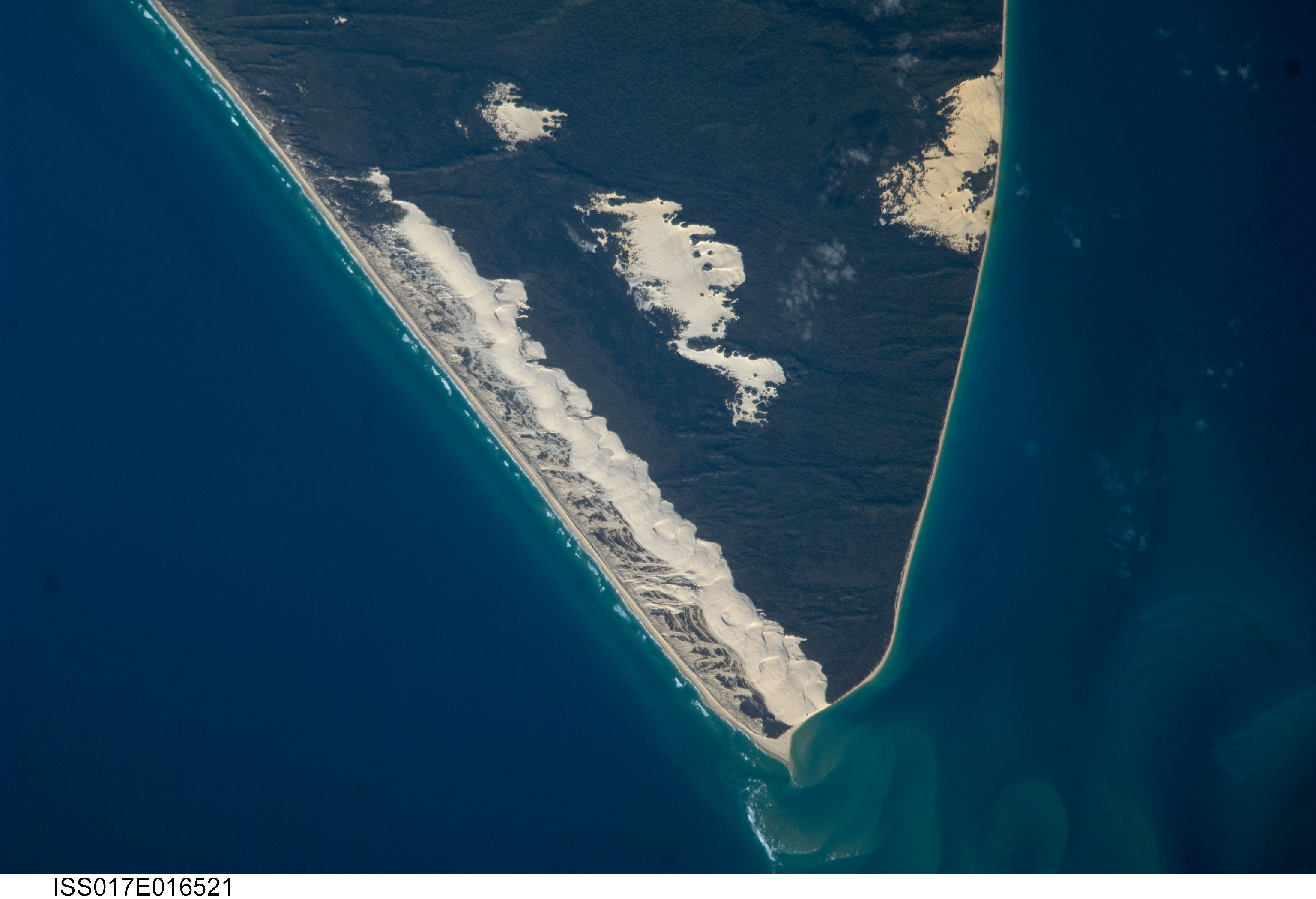
Image Caption: Sandy Cape, Fraser Island, Australia
Fraser Island, the world's largest sand island, is located along the coastline of Queensland, Australia, and it includes Great Sandy National Park. The island was designated a World Heritage site in 1992, in part due to its outstanding preservation of geological processes related to sand dune formation. The island's dune fields preserve a record of sand deposition and movement related to sea level rise and fall extending back over 700,000 years. In addition to sand dunes, the island also preserves an interesting range of vegetation--including vine rainforest, stands of eucalpyt trees, and mangroves--and diverse animals, including crabs, parrots, sugar gliders, and flying foxes.
This astronaut photograph highlights the northernmost portion of the island, known as Sandy Cape. Active white sand dunes contrast with dark green vegetation that anchors older dune sets. Irregular patches of sand dunes surrounded by vegetation are known as sand blows (or blowouts), formed when the vegetation cover is disturbed by wind, fire, or human activities. The exposed underlaying sand can then move and form new dunes, sometimes at rates of up to 1 meter/year. Coastal sand dune fields, such as the one located along the eastern side of Sandy Cape (center), will remain active until anchored by vegetation, or until no more sand is available to form new dunes.
