ISS017-E-15361
| NASA Photo ID | ISS017-E-15361 |
| Focal Length | 28mm |
| Date taken | 2008.09.05 |
| Time taken | 12:36:10 GMT |

Cloud masks available for this image:
Spacecraft nadir point: 23.5° N, 49.8° W
Photo center point: 23.2° N, 62.7° W
Photo center point by machine learning:
Photo center point: 23.2° N, 62.7° W
Photo center point by machine learning:
Nadir to Photo Center: West
Spacecraft Altitude: 188 nautical miles (348km)
Country or Geographic Name: | ATLANTIC OCEAN |
Features: | PAN-HURRICANE IKE |
| Features Found Using Machine Learning: | PAN- |
Cloud Cover Percentage: | 75 (51-75)% |
Sun Elevation Angle: | 48° |
Sun Azimuth: | 107° |
Camera: | Nikon D2Xs Electronic Still Camera |
Focal Length: | 28mm |
Camera Tilt: | High Oblique |
Format: | 4288E: 4288 x 2848 pixel CMOS sensor, RGBG imager color filter |
Film Exposure: | |
| Additional Information | |
| Width | Height | Annotated | Cropped | Purpose | Links |
|---|---|---|---|---|---|
| 3072 pixels | 2098 pixels | No | No | Download Image | |
| 640 pixels | 437 pixels | No | No | Download Image |
Download Packaged File
Download a Google Earth KML for this Image
View photo footprint information
Download a GeoTIFF for this photo
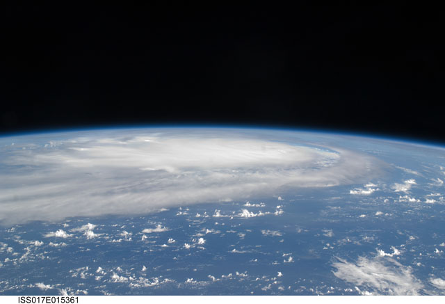
Image Caption: ISS017-E-015361 (5 Sept. 2008) --- When this image was taken of Hurricane Ike from the International Space Station's vantage point of 220 statute miles above Earth on Sept. 5, the eye of it was centered at 23.3 degrees north latitude and 62.0 degrees west longitude and moving 260 degrees at 17.2 miles per hour. The winds were sustained at 121 miles per hour with gusts to 149.8 miles per hour. The hurricane had not yet passed over Cuba and entered the Gulf of Mexico when this photo was taken.
