ISS017-E-13025
| NASA Photo ID | ISS017-E-13025 |
| Focal Length | 400mm |
| Date taken | 2008.08.12 |
| Time taken | 09:39:54 GMT |
Resolutions offered for this image:
1000 x 664 pixels 540 x 359 pixels 540 x 405 pixels 3072 x 2098 pixels 640 x 437 pixels
1000 x 664 pixels 540 x 359 pixels 540 x 405 pixels 3072 x 2098 pixels 640 x 437 pixels


Cloud masks available for this image:
Spacecraft nadir point: 26.6° N, 4.7° E
Photo center point: 26.3° N, 6.9° E
Photo center point by machine learning:
Photo center point: 26.3° N, 6.9° E
Photo center point by machine learning:
Nadir to Photo Center: East
Spacecraft Altitude: 184 nautical miles (341km)
Country or Geographic Name: | ALGERIA |
Features: | TIFERNINE DUNE FIELD |
| Features Found Using Machine Learning: | |
Cloud Cover Percentage: | 0 (no clouds present) |
Sun Elevation Angle: | 58° |
Sun Azimuth: | 105° |
Camera: | Nikon D2Xs Electronic Still Camera |
Focal Length: | 400mm |
Camera Tilt: | 36 degrees |
Format: | 4288E: 4288 x 2848 pixel CMOS sensor, RGBG imager color filter |
Film Exposure: | |
| Additional Information | |
| Width | Height | Annotated | Cropped | Purpose | Links |
|---|---|---|---|---|---|
| 1000 pixels | 664 pixels | No | Yes | Earth From Space collection | Download Image |
| 540 pixels | 359 pixels | Yes | Yes | Earth From Space collection | Download Image |
| 540 pixels | 405 pixels | Yes | Yes | NASA's Earth Observatory web site | Download Image |
| 3072 pixels | 2098 pixels | No | No | Download Image | |
| 640 pixels | 437 pixels | No | No | Download Image |
Download Packaged File
Download a Google Earth KML for this Image
View photo footprint information
Download a GeoTIFF for this photo
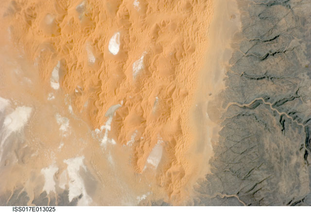
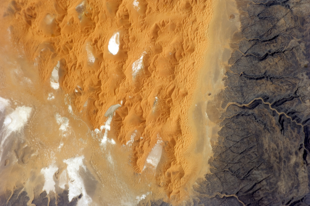
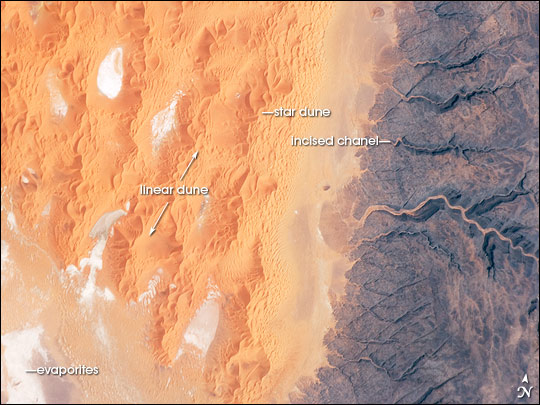
Image Caption: Tifernine Dune Field, Algeria
The Tifernine Dune Field is located at the southernmost tip of the Grand Erg Oriental, a "dune sea" that occupies a large portion of the Sahara Desert in eastern Algeria. This astronaut photograph illustrates the interface between the yellow-orange sand dunes of the field and dark brown consolidated rocks of the Tinrhert Plateau to the south and east (image right). Three distinct landforms are visible in the image, each providing information about past and present climate in the area.
The oldest landform is represented by the rocks of the Tinrhert Plateau, where numerous channels incise the bedrock; these channels were eroded during a wet and cool climate period, most probably by glacial meltwater streams. As the dry and hot climate that characterizes the Sahara today became established, water ceased to flow in these channels. Winds eroded and moved large amounts of drying sediment (sand, silt, and clay), which piled up in large, linear dunes that roughly parallel the direction of the prevailing winds of the time (image center).
The present climate is still hot and dry, but current wind directions are more variable. The variable winds are modifying the older, linear dunes, creating star dunes, recognizable by a starfish-like pattern when seen from above. White to grey regions within the dune field are exposed deposits of silt and clay, together with evaporite minerals (such as halite, or common table salt) formed by evaporation of water that collected in small basins between the dunes.
