ISS016-E-31086

| NASA Photo ID | ISS016-E-31086 |
| Focal Length | 400mm |
| Date taken | 2008.03.03 |
| Time taken | 20:00:12 GMT |
Resolutions offered for this image:
1000 x 749 pixels 540 x 404 pixels 540 x 405 pixels 3032 x 2064 pixels 639 x 435 pixels
1000 x 749 pixels 540 x 404 pixels 540 x 405 pixels 3032 x 2064 pixels 639 x 435 pixels
Cloud masks available for this image:
Spacecraft nadir point: 22.2° N, 101.3° W
Photo center point: 20.3° N, 100.9° W
Photo center point by machine learning:
Photo center point: 20.3° N, 100.9° W
Photo center point by machine learning:
Nadir to Photo Center: South
Spacecraft Altitude: 183 nautical miles (339km)
Country or Geographic Name: | MEXICO |
Features: | CERRO CULIACAN, RADIAL DRAINAGE |
| Features Found Using Machine Learning: | |
Cloud Cover Percentage: | 10 (1-10)% |
Sun Elevation Angle: | 58° |
Sun Azimuth: | 210° |
Camera: | Kodak DCS760c Electronic Still Camera |
Focal Length: | 400mm |
Camera Tilt: | 32 degrees |
Format: | 3060E: 3060 x 2036 pixel CCD, RGBG array |
Film Exposure: | |
| Additional Information | |
| Width | Height | Annotated | Cropped | Purpose | Links |
|---|---|---|---|---|---|
| 1000 pixels | 749 pixels | No | Yes | Earth From Space collection | Download Image |
| 540 pixels | 404 pixels | Yes | Yes | Earth From Space collection | Download Image |
| 540 pixels | 405 pixels | Yes | Yes | NASA's Earth Observatory web site | Download Image |
| 3032 pixels | 2064 pixels | No | No | Download Image | |
| 639 pixels | 435 pixels | No | No | Download Image |
Download Packaged File
Download a Google Earth KML for this Image
View photo footprint information
Download a GeoTIFF for this photo
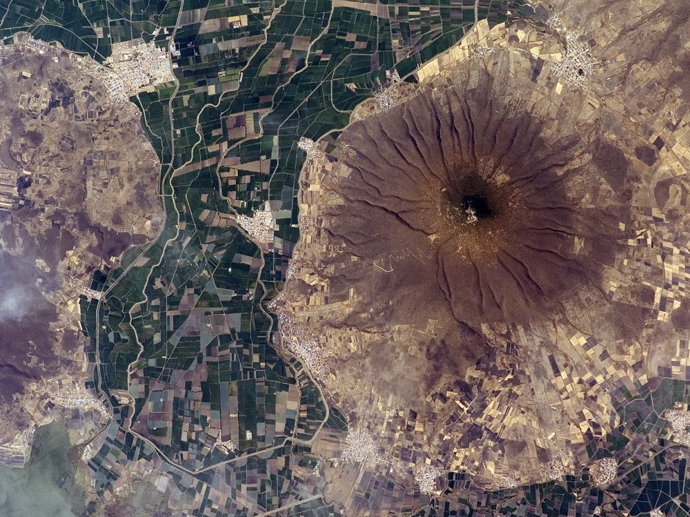
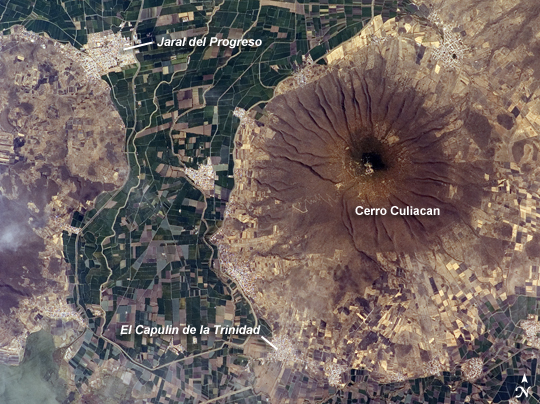
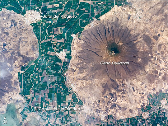
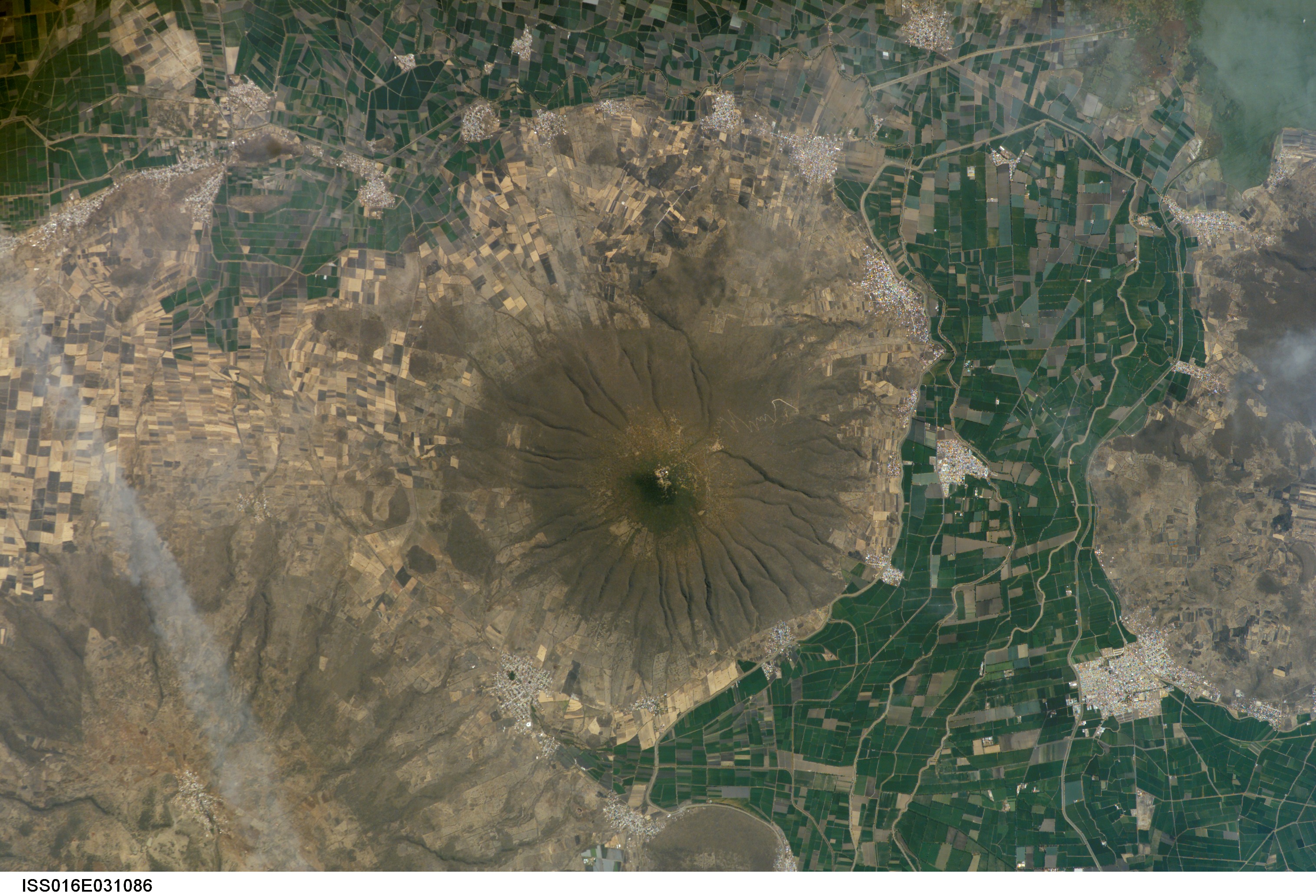
Image Caption: Cerro Culiacan, Guanajuato, Mexico
This astronaut photograph highlights Cerro (Spanish for "hill") Culiacan, part of the 50,000 km2 Michoacan-Guanajuato volcanic field of west-central Mexico. The volcanic field contains over 1400 known vents, with cinder cones being the dominant landform. Cerro Culiacan however, is a shield volcano formed by basaltic lavas; it most likely formed during the Pleistocene Epoch approximately 10,000 to 2 million years ago. Shield volcanoes in the Michoacan-Guanajuato field tend to have steeper slopes than similar volcanic structures elsewhere (namely Iceland; this is perhaps due to slightly higher-viscosity lavas), and the 1100-meter high Cerro Culiacan is no exception.
The permeable, highly fractured basalt of Culiacan is an important component of the local hydrology. Precipitation that falls on the slopes of the hill swiftly infiltrates down into sediments of the valley floor, providing sufficient moisture to support agriculture (green and brown fields at image center) and, in turn, several small cities such as Jaral del Progreso and El Capulin de la Trinidad (light gray regions with street grids). Precipitation has also incised the slopes of Cerro Culiacan with a radial drainage pattern, extending outwards from the peak in all directions much like the spokes of a bicycle wheel.
