ISS016-E-31056
| NASA Photo ID | ISS016-E-31056 |
| Focal Length | 400mm |
| Date taken | 2008.03.03 |
| Time taken | 19:56:45 GMT |
Resolutions offered for this image:
1000 x 729 pixels 540 x 394 pixels 540 x 334 pixels 3032 x 2064 pixels 639 x 435 pixels
1000 x 729 pixels 540 x 394 pixels 540 x 334 pixels 3032 x 2064 pixels 639 x 435 pixels


Cloud masks available for this image:
Spacecraft nadir point: 32.0° N, 111.2° W
Photo center point: 31.0° N, 110.2° W
Photo center point by machine learning:
Photo center point: 31.0° N, 110.2° W
Photo center point by machine learning:
Nadir to Photo Center: Southeast
Spacecraft Altitude: 182 nautical miles (337km)
Country or Geographic Name: | MEXICO |
Features: | CANANEA, AGUAJE, COPPER MINE |
| Features Found Using Machine Learning: | |
Cloud Cover Percentage: | 10 (1-10)% |
Sun Elevation Angle: | 51° |
Sun Azimuth: | 188° |
Camera: | Kodak DCS760c Electronic Still Camera |
Focal Length: | 400mm |
Camera Tilt: | 25 degrees |
Format: | 3060E: 3060 x 2036 pixel CCD, RGBG array |
Film Exposure: | |
| Additional Information | |
| Width | Height | Annotated | Cropped | Purpose | Links |
|---|---|---|---|---|---|
| 1000 pixels | 729 pixels | No | Yes | Earth From Space collection | Download Image |
| 540 pixels | 394 pixels | Yes | Yes | Earth From Space collection | Download Image |
| 540 pixels | 334 pixels | Yes | Yes | NASA's Earth Observatory web site | Download Image |
| 3032 pixels | 2064 pixels | No | No | Download Image | |
| 639 pixels | 435 pixels | No | No | Download Image |
Download Packaged File
Download a Google Earth KML for this Image
View photo footprint information
Download a GeoTIFF for this photo
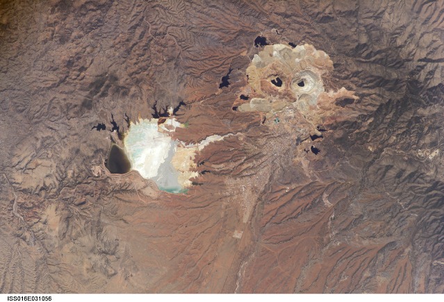
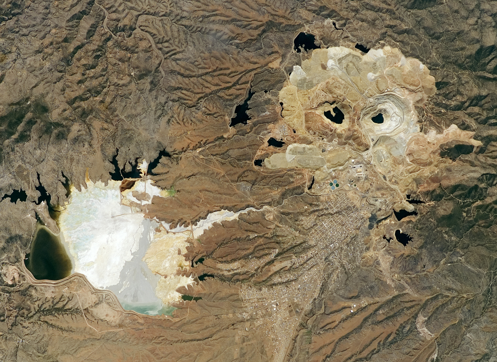
Image Caption: Cananea Copper Mine, Sonora, Mexico
One of the largest open-pit copper mines in the world, the Cananea mine produced over 164,000 tonnes of copper in 2006. The mine is located approximately 40 km south of the border between the USA (Arizona) and Mexico (Sonora). Copper and gold ores at Cananea are found in a porphyry copper deposit, a geological structure formed by crystal-rich magma moving upwards through pre-existing rock layers. A porphyry - an igneous rock with large crystals in a fine-grained matrix - is formed as the magma cools and crystallizes. While crystallization is occurring, hot fluids can circulate through the magma and surrounding rocks via fractures. This hydrothermal alteration of the rocks typically forms copper-bearing and other minerals. Much of the Cananea mine's ore is concentrated in breccia pipes - mineralized rod or chimney-shaped bodies that contain broken rock fragments.
The active, 2 km in diameter Colorada Pit (image top right) is recognizable in this astronaut photograph by the concentric steps or benches cut around its perimeter (see larger image). These benches allow for access into the pit for extraction of ore and waste materials. Water (black) is visible filling the bottom of the pit, and several other basins in the surrounding area. The city of Cananea - marked by its street grid - is located to the northeast of the mine workings. A leachate reservoir is located to the east of the mine (image lower left) for removal and evaporation of water pumped from the mine workings - the bluish-white coloration of deposits near the reservoir suggests the high mineral content of the leachate.
The mine workings at Cananea are significant in the recent history of Mexico, as poor working conditions there in 1906 led to a miner's strike that resulted in 19 deaths. This event is generally considered to a major catalyst of the Mexican Revolution of 1910, as well as the beginning of Mexico's labor movement. Current environmental and economic conditions at the mine led to a worker strike that halted mine operations in 2007.
