ISS016-E-30080

| NASA Photo ID | ISS016-E-30080 |
| Focal Length | 800mm |
| Date taken | 2008.02.17 |
| Time taken | 14:40:55 GMT |
Resolutions offered for this image:
1000 x 736 pixels 540 x 397 pixels 540 x 405 pixels 3032 x 2008 pixels 639 x 423 pixels
1000 x 736 pixels 540 x 397 pixels 540 x 405 pixels 3032 x 2008 pixels 639 x 423 pixels
Cloud masks available for this image:
Spacecraft nadir point: 51.5° N, 7.2° W
Photo center point: 53.1° N, 9.2° W
Photo center point by machine learning:
Photo center point: 53.1° N, 9.2° W
Photo center point by machine learning:
Nadir to Photo Center: Northwest
Spacecraft Altitude: 176 nautical miles (326km)
Country or Geographic Name: | IRELAND |
Features: | BLACK HEAD, FOR., GALWAY BAY |
| Features Found Using Machine Learning: | |
Cloud Cover Percentage: | 10 (1-10)% |
Sun Elevation Angle: | 22° |
Sun Azimuth: | 211° |
Camera: | Kodak DCS760c Electronic Still Camera |
Focal Length: | 800mm |
Camera Tilt: | 41 degrees |
Format: | 3060E: 3060 x 2036 pixel CCD, RGBG array |
Film Exposure: | |
| Additional Information | |
| Width | Height | Annotated | Cropped | Purpose | Links |
|---|---|---|---|---|---|
| 1000 pixels | 736 pixels | No | Yes | Earth From Space collection | Download Image |
| 540 pixels | 397 pixels | Yes | Yes | Earth From Space collection | Download Image |
| 540 pixels | 405 pixels | Yes | Yes | NASA's Earth Observatory web site | Download Image |
| 3032 pixels | 2008 pixels | No | No | Download Image | |
| 639 pixels | 423 pixels | No | No | Download Image |
Download Packaged File
Download a Google Earth KML for this Image
View photo footprint information
Download a GeoTIFF for this photo
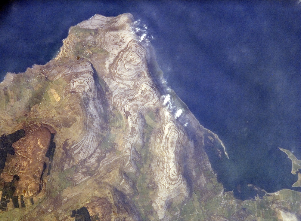
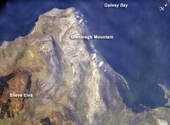
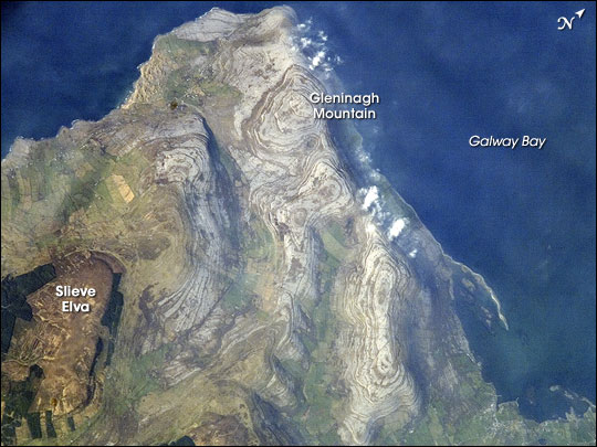
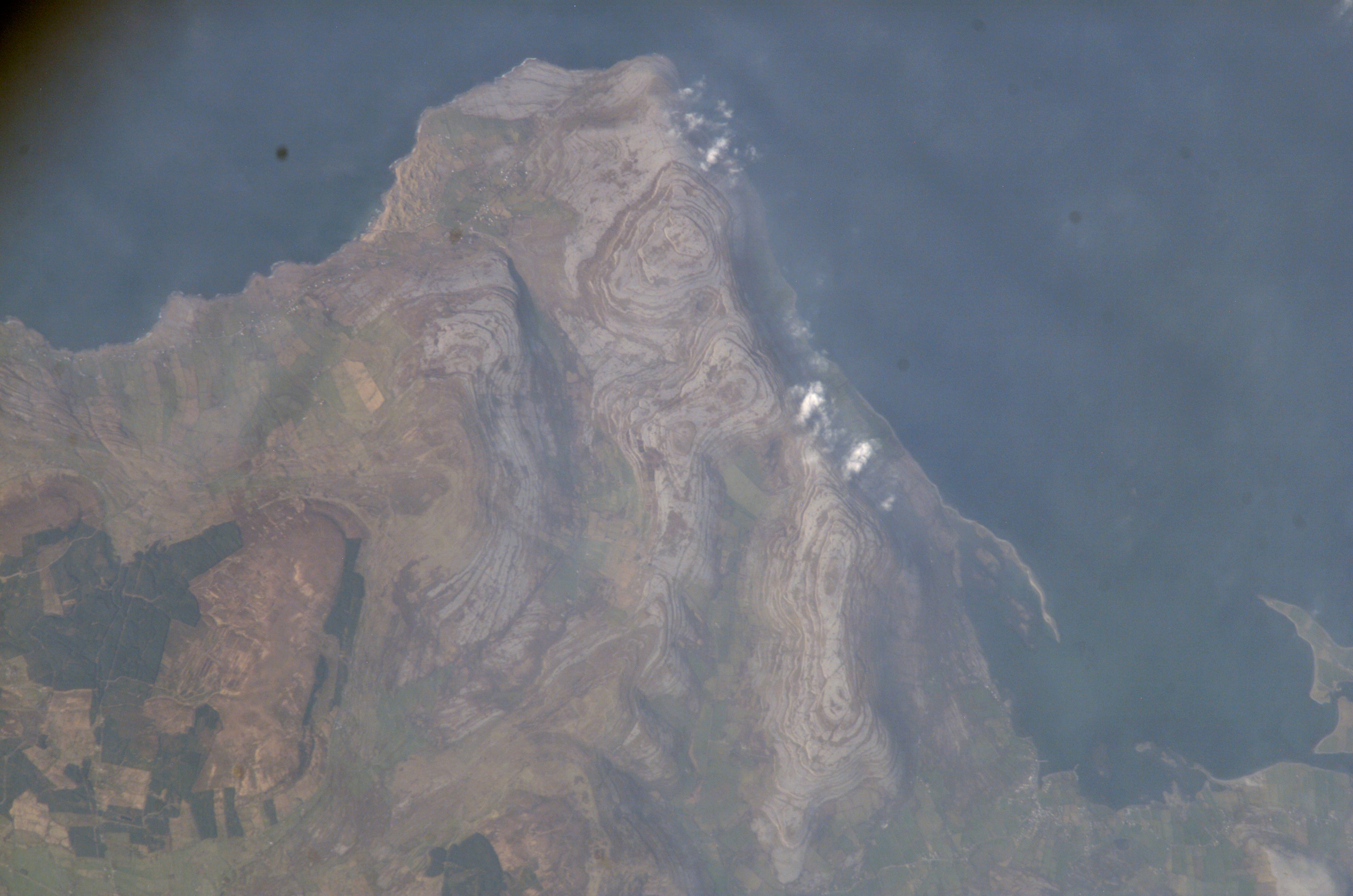
Image Caption: Burren Plateau, County Clare, Ireland
Adjoining Galway Bay to the north, the Burren (from the Gaelic for "stony place") Plateau is a example of karst terrain. Karst terrain is generally formed when sedimentary rocks are dissolved by groundwater. Most karst occurs in limestones or dolostones - rocks made primarily from the minerals calcite or dolomite. Groundwater and surface water moves through fractures in the rock, dissolving it over time, forming voids and channels. As the voids grow and connect, greater dissolution of the rock occurs; when overlying rock and soil can no longer be supported, collapse features such as sinkholes form. Over time, this can turn an originally flat landscape into one with significant topography.
This astronaut photograph illustrates the northwestern-most portion of the Burren Plateau, characterized by the distinctive bare exposures of almost horizontal, layered Paleozoic limestone (light gray, with brown concentric banding) that form Gleninagh Mountain at image center. At 345 meters above sea level, Slieve Elva (image lower left) - capped with younger dark brown shale and bordered by dark green vegetation - is the highest point on the Plateau. The rounded character of limestone hills and intervening valleys of Gleninagh Mountain are the result of both dissolution of the limestone by water, and removal of loose material by past glaciers.
A very thin cloud cover is visible over Gleninagh Mountain. Despite the barren character of this portion of the Burren Plateau, thin soils are present and the area is used for grazing of cattle during the wintertime. Numerous small springs - another hallmark of karst terrain, as surface streams tend to disappear underground via fractures - provide water for both cattle and human use in this otherwise dry landscape.
