ISS016-E-19239
| NASA Photo ID | ISS016-E-19239 |
| Focal Length | 400mm |
| Date taken | 2007.12.29 |
| Time taken | 14:12:57 GMT |
Resolutions offered for this image:
1000 x 655 pixels 540 x 354 pixels 540 x 540 pixels 3032 x 2064 pixels 639 x 435 pixels
1000 x 655 pixels 540 x 354 pixels 540 x 540 pixels 3032 x 2064 pixels 639 x 435 pixels

Cloud masks available for this image:
Spacecraft nadir point: 10.4° N, 37.1° E
Photo center point: 8.8° N, 38.0° E
Photo center point by machine learning:
Photo center point: 8.8° N, 38.0° E
Photo center point by machine learning:
Nadir to Photo Center: Southeast
Spacecraft Altitude: 181 nautical miles (335km)
Country or Geographic Name: | ETHIOPIA |
Features: | BEDADA TOLA, ENYO, CRATER |
| Features Found Using Machine Learning: | |
Cloud Cover Percentage: | 10 (1-10)% |
Sun Elevation Angle: | 14° |
Sun Azimuth: | 243° |
Camera: | Kodak DCS760c Electronic Still Camera |
Focal Length: | 400mm |
Camera Tilt: | 31 degrees |
Format: | 3060E: 3060 x 2036 pixel CCD, RGBG array |
Film Exposure: | |
| Additional Information | |
| Width | Height | Annotated | Cropped | Purpose | Links |
|---|---|---|---|---|---|
| 1000 pixels | 655 pixels | No | Yes | Earth From Space collection | Download Image |
| 540 pixels | 354 pixels | Yes | Yes | Earth From Space collection | Download Image |
| 540 pixels | 540 pixels | Yes | Yes | NASA's Earth Observatory web site | Download Image |
| 3032 pixels | 2064 pixels | No | No | Download Image | |
| 639 pixels | 435 pixels | No | No | Download Image |
Download Packaged File
Download a Google Earth KML for this Image
View photo footprint information
Download a GeoTIFF for this photo
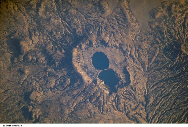
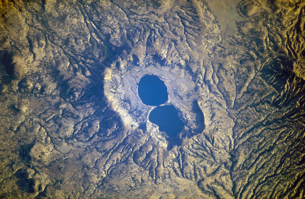
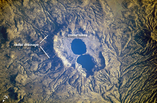
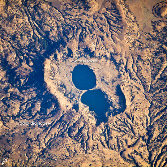
Image Caption: Dendi Caldera, Ethiopia
The Dendi Caldera is located on the Ethiopian Plateau, approximately 86 km to the southwest of Addis Ababa. A caldera is a geological feature formed by the near-total eruption of magma from beneath a volcano, leading to collapse of the volcanic structure into the now-empty magma chamber. This collapse typically leaves a crater or depression where the volcano stood, and later volcanic activity can fill the caldera with younger lavas, ash, pyroclastic rocks, and sediments. While much of the volcanic rock in the area is comprised of basalt erupted as part of the opening of the East African Rift, more silica-rich rock types (characterized by minerals such as quartz and feldspar) are also present.
The approximately 4 km wide Dendi Caldera includes some of this silica-rich volcanic rock - the rim of the caldera, visible in this astronaut photograph, is comprised mainly of poorly-consolidated ash erupted during the Tertiary Period (approximately 65 - 2 million years ago).A notable feature of the Dendi Caldera is the presence of two shallow lakes formed within the central depression (image center). This image also highlights a radial drainage pattern surrounding the remnants of the Dendi volcanic cone. Such patterns typically form around volcanoes, as rainfall has equal potential to move downslope on all sides of the cone and incise channels. No historical volcanic eruptions of Dendi are recorded, however the Wonchi Caldera 13 km to the southwest (not shown) may have been active as recently as A.D. 550.
