ISS015-E-7934

| NASA Photo ID | ISS015-E-7934 |
| Focal Length | 400mm |
| Date taken | 2007.05.13 |
| Time taken | 21:04:31 GMT |
Resolutions offered for this image:
1000 x 1086 pixels 540 x 586 pixels 540 x 540 pixels 3032 x 2064 pixels 639 x 435 pixels
1000 x 1086 pixels 540 x 586 pixels 540 x 540 pixels 3032 x 2064 pixels 639 x 435 pixels

Cloud masks available for this image:
Spacecraft nadir point: 23.2° N, 105.9° W
Photo center point: 23.2° N, 106.3° W
Photo center point by machine learning:
Photo center point: 23.2° N, 106.3° W
Photo center point by machine learning:
Nadir to Photo Center: West
Spacecraft Altitude: 177 nautical miles (328km)
Country or Geographic Name: | MEXICO |
Features: | GULF OF CALIFORNIA, MAZATLAN |
| Features Found Using Machine Learning: | |
Cloud Cover Percentage: | 10 (1-10)% |
Sun Elevation Angle: | 61° |
Sun Azimuth: | 267° |
Camera: | Kodak DCS760c Electronic Still Camera |
Focal Length: | 400mm |
Camera Tilt: | 8 degrees |
Format: | 3060E: 3060 x 2036 pixel CCD, RGBG array |
Film Exposure: | |
| Additional Information | |
| Width | Height | Annotated | Cropped | Purpose | Links |
|---|---|---|---|---|---|
| 1000 pixels | 1086 pixels | No | Yes | Earth From Space collection | Download Image |
| 540 pixels | 586 pixels | Yes | Yes | Earth From Space collection | Download Image |
| 540 pixels | 540 pixels | Yes | Yes | NASA's Earth Observatory web site | Download Image |
| 3032 pixels | 2064 pixels | No | No | Download Image | |
| 639 pixels | 435 pixels | No | No | Download Image |
Download Packaged File
Download a Google Earth KML for this Image
View photo footprint information
Download a GeoTIFF for this photo
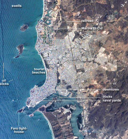
Image Caption: ISS015-E-07934 (13 May 2007) --- Mazatlan, Mexico is featured in this image photographed by an Expedition 15 crewmember on the International Space Station. Mazatlan is Mexico's largest port, situated on one of the best estuaries on Mexico's Pacific coast, illustrated well in this image. Docks and naval yards line the north side of the estuary. The city itself appears as a series of light-toned city blocks covering the center of the image. Mazatlan (population of 352,000 in 2005) is growing northward from the downtown peninsula, with tourist beaches backed by hotels, and a marina and golf courses just beyond. No city growth yet appears on the south side the estuary where farm lands can be seen. The famous Faro Lighthouse occupies the top of a steep island--now connected by a bridge to the mainland--at the mouth of the estuary (top center). The Faro Lighthouse is the second tallest in the world behind Gibraltar's. The wide, straight, almost vertical line of the railroad appears to bisect the picture. This image shows sea features well, primarily ocean swells coming in from the southwest, which appear as a series of parallel lines covering the entire sea surface in this view. An oil slick offshore of the tourist beaches appears as a dark line along the left side of the image.
Mazatlan, Mexico:
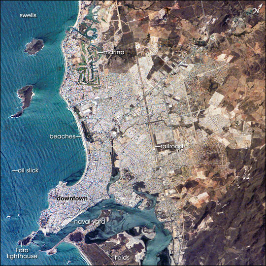
Mazatlan is Mexico's largest port, situated on one of the best estuaries (bottom center of image) on Mexico's Pacific coast. The city appears as a series of light-toned geometric blocks covering the center of this astronaut photograph. The image also shows the docks and naval yards that line the north side of the estuary. Mazatlan (population 352,000 in 2005) is growing northward from the downtown peninsula, with tourist beaches backed by hotels, and a marina and golf courses just beyond. No city growth yet appears on the south side of the estuary, where narrow rectangles of farm land can be seen.
The famous Faro Lighthouse occupies the top of a steep island--now connected by a bridge to the mainland--at the mouth of the estuary (image lower left). The Faro Lighthouse is the second tallest in the world, after Gibraltar's. The wide, straight, almost vertical line of the railroad bisects the city.
This image shows sea features well, primarily ocean swells coming in from the southwest, which appear as a series of parallel lines covering the entire sea surface in this image. The diverse activities that go on in busy urban areas do not always mix easily: an oil slick offshore of the tourist beaches appears as a dark line along the left side of the image.
Mazatlan, Mexico:
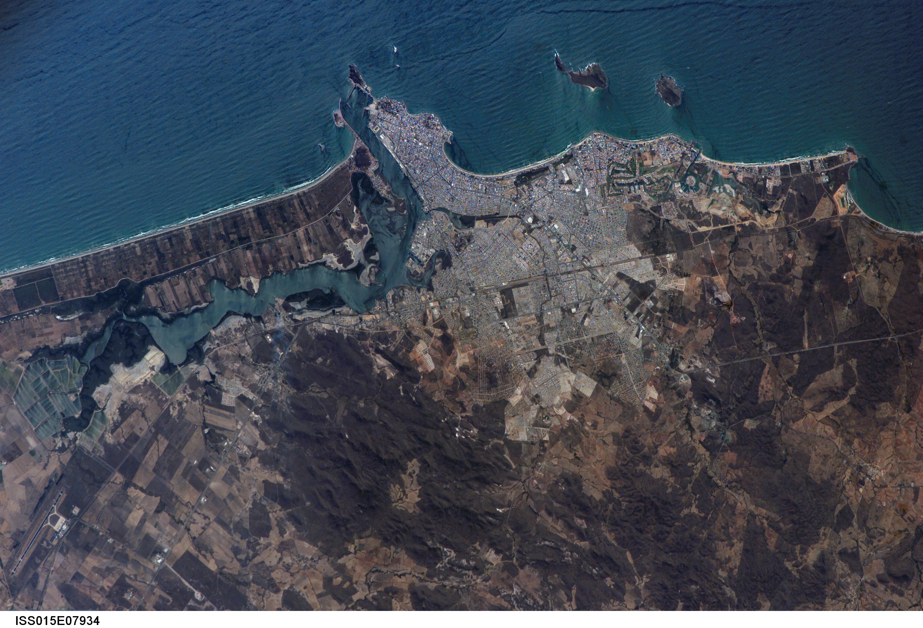
Mazatlan is Mexico's largest port, situated on one of the best estuaries (bottom center of image) on Mexico's Pacific coast. The city appears as a series of light-toned geometric blocks covering the center of this astronaut photograph. The image also shows the docks and naval yards that line the north side of the estuary. Mazatlan (population 352,000 in 2005) is growing northward from the downtown peninsula, with tourist beaches backed by hotels, and a marina and golf courses just beyond. No city growth yet appears on the south side of the estuary, where narrow rectangles of farm land can be seen.
The famous Faro Lighthouse occupies the top of a steep island--now connected by a bridge to the mainland--at the mouth of the estuary (image lower left). The Faro Lighthouse is the second tallest in the world, after Gibraltar's. The wide, straight, almost vertical line of the railroad bisects the city.
This image shows sea features well, primarily ocean swells coming in from the southwest, which appear as a series of parallel lines covering the entire sea surface in this image. The diverse activities that go on in busy urban areas do not always mix easily: an oil slick offshore of the tourist beaches appears as a dark line along the left side of the image.
