ISS015-E-7771
| NASA Photo ID | ISS015-E-7771 |
| Focal Length | 400mm |
| Date taken | 2007.05.12 |
| Time taken | 19:17:25 GMT |
Resolutions offered for this image:
1000 x 777 pixels 540 x 420 pixels 540 x 405 pixels 3032 x 2064 pixels 639 x 435 pixels
1000 x 777 pixels 540 x 420 pixels 540 x 405 pixels 3032 x 2064 pixels 639 x 435 pixels


Cloud masks available for this image:
Spacecraft nadir point: 13.2° N, 63.5° W
Photo center point: 11.9° N, 64.6° W
Photo center point by machine learning:
Photo center point: 11.9° N, 64.6° W
Photo center point by machine learning:
Nadir to Photo Center: Southwest
Spacecraft Altitude: 178 nautical miles (330km)
Country or Geographic Name: | VENEZUELA |
Features: | BLANQUILLA ISLAND |
| Features Found Using Machine Learning: | |
Cloud Cover Percentage: | 10 (1-10)% |
Sun Elevation Angle: | 45° |
Sun Azimuth: | 283° |
Camera: | Kodak DCS760c Electronic Still Camera |
Focal Length: | 400mm |
Camera Tilt: | 30 degrees |
Format: | 3060E: 3060 x 2036 pixel CCD, RGBG array |
Film Exposure: | |
| Additional Information | |
| Width | Height | Annotated | Cropped | Purpose | Links |
|---|---|---|---|---|---|
| 1000 pixels | 777 pixels | No | Yes | Earth From Space collection | Download Image |
| 540 pixels | 420 pixels | Yes | Yes | Earth From Space collection | Download Image |
| 540 pixels | 405 pixels | Yes | Yes | NASA's Earth Observatory web site | Download Image |
| 3032 pixels | 2064 pixels | No | No | Download Image | |
| 639 pixels | 435 pixels | No | No | Download Image |
Download Packaged File
Download a Google Earth KML for this Image
View photo footprint information
Download a GeoTIFF for this photo
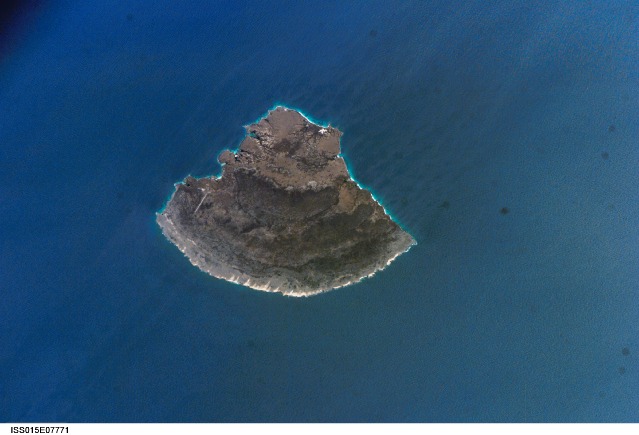
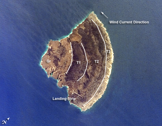
Image Caption: ISS015-E-07771 (12 May 2007) --- Isla Blanquilla, Venezuela is featured in this image photographed by an Expedition 15 crewmember on the International Space Station. The small island of Blanquilla is so named for its white sand beaches, visible in this image as a bright border along the northeastern -- eastern shoreline. Located approximately 292 kilometers (182 miles) northeast of Caracas, this Caribbean island is a popular destination for divers and tourists arriving by boat or airplane (the airstrip is visible at left center). Surface currents extending from the western coastline of the island (right center) are caused by easterly trade winds. According to scientists, this dominant wind has also caused movement of beach sand to form white "fingers" extending inland along the east coast (bottom center). The flora and fauna of Isla Blanquilla are an interesting mixture of arid (cacti, iguanas) and introduced species (wild donkeys and goats), but it is particularly notable for the presence of black coral. Black coral (order Antipatharia) is something of a misnomer, as it refers to the skeleton of the coral rather than the living organism (which is typically brightly colored). Black corals around the world are harvested for use in jewelry and other craftwork, so much so that the species has been listed for protection under the Convention on International Trade in Endangered Species of Wild Fauna and Flora. The island is the southernmost subaerial (above water) exposure of the Aves Ridge, a seafloor topography feature of the southernmost Caribbean ocean. The western third of the island is comprised of Cretaceous to Paleocene granitic rock (brown to tan), while the remainder consists of three limestone terraces of Pleistocene age deposited on the older granitic basement rock. The terraces decrease in age outwards from the western third of the island. The terraces record fluctuating sea levels, thought to be related to glacial advances and retreats during the Pleistocene together with tectonic uplift of the island.
Isla Blanquilla, Venezuela:
The small island of Blanquilla is named for its white sand beaches, visible in this astronaut photograph as a bright border along the northeastern-eastern shoreline. Located approximately 292 kilometers (182 miles) northeast of Caracas, this Caribbean island is a popular destination for divers and tourists arriving by boat or airplane (the airstrip is visible at image right). Surface currents extending from the western coastline of the island (image left) are caused by easterly trade winds. This dominant wind has also caused movement of beach sand to form white "fingers" extending inland along the east coast (top center).
The plants and animals of Isla Blanquilla are an interesting mixture of arid (cacti, iguanas) and introduced species (wild donkeys and goats), but it is particularly notable for the presence of black coral. Black coral is something of a misnomer, as it refers to the skeleton of the coral rather than the living organism, which is usually brightly colored. Black corals around the world are harvested for use in jewelry and other craftwork, so much so that the species has been listed for protection under the Convention on International Trade in Endangered Species of Wild Fauna and Flora (CITES).
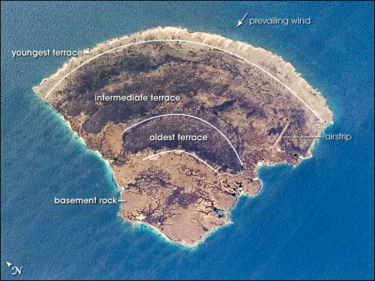
The island is the southernmost above-water exposure of the Aves Ridge, a seafloor topography feature of the southernmost Caribbean Sea. The island's basement rock (the oldest rocks in an area) is visible in the western (bottom) third of the island. These granite rocks date back to the last part of the Mesozoic Era (the Cretaceous Period, 146-65 million years ago) and the first part of the Cenozoic Era (the Paleocene Epoch, 65-54.8 million years ago). The remainder of the island consists of three limestone terraces deposited on the older basement rock. The terraces get younger from west to east (bottom to top) across the island. The terraces record fluctuating sea levels during the Pleistocene Epoch (the Ice Age, 1.8 to about 10,000 years ago). The changes in sea level on the island may have been due to glacial advances and retreats during the Ice Age, or tectonic uplift of the island, or a combination of both processes.
References
Schubert, C. (1977). Pleistocene marine terraces of La Blanquilla Island, Venezuela, and their diagenesis. In D. L. Taylor, Ed., Proceedings of the Third International Coral Reef Symposium (pp.149-154). Miami: University of Miami. University of California Museum of Paleontology. Tour of Geologic Time. Accessed November 21, 2007.
Isla Blanquilla, Venezuela:
The small island of Blanquilla is named for its white sand beaches, visible in this astronaut photograph as a bright border along the northeastern-eastern shoreline. Located approximately 292 kilometers (182 miles) northeast of Caracas, this Caribbean island is a popular destination for divers and tourists arriving by boat or airplane (the airstrip is visible at image right). Surface currents extending from the western coastline of the island (image left) are caused by easterly trade winds. This dominant wind has also caused movement of beach sand to form white "fingers" extending inland along the east coast (top center).
The plants and animals of Isla Blanquilla are an interesting mixture of arid (cacti, iguanas) and introduced species (wild donkeys and goats), but it is particularly notable for the presence of black coral. Black coral is something of a misnomer, as it refers to the skeleton of the coral rather than the living organism, which is usually brightly colored. Black corals around the world are harvested for use in jewelry and other craftwork, so much so that the species has been listed for protection under the Convention on International Trade in Endangered Species of Wild Fauna and Flora (CITES).
The island is the southernmost above-water exposure of the Aves Ridge, a seafloor topography feature of the southernmost Caribbean Sea. The island's basement rock (the oldest rocks in an area) is visible in the western (bottom) third of the island. These granite rocks date back to the last part of the Mesozoic Era (the Cretaceous Period, 146-65 million years ago) and the first part of the Cenozoic Era (the Paleocene Epoch, 65-54.8 million years ago). The remainder of the island consists of three limestone terraces deposited on the older basement rock. The terraces get younger from west to east (bottom to top) across the island. The terraces record fluctuating sea levels during the Pleistocene Epoch (the Ice Age, 1.8 to about 10,000 years ago). The changes in sea level on the island may have been due to glacial advances and retreats during the Ice Age, or tectonic uplift of the island, or a combination of both processes.
References
Schubert, C. (1977). Pleistocene marine terraces of La Blanquilla Island, Venezuela, and their diagenesis. In D. L. Taylor, Ed., Proceedings of the Third International Coral Reef Symposium (pp.149-154). Miami: University of Miami. University of California Museum of Paleontology. Tour of Geologic Time. Accessed November 21, 2007.
