ISS015-E-5983

| NASA Photo ID | ISS015-E-5983 |
| Focal Length | 800mm |
| Date taken | 2007.05.01 |
| Time taken | 18:18:56 GMT |
Resolutions offered for this image:
1000 x 611 pixels 540 x 330 pixels 540 x 334 pixels 3032 x 2064 pixels 639 x 435 pixels
1000 x 611 pixels 540 x 330 pixels 540 x 334 pixels 3032 x 2064 pixels 639 x 435 pixels

Cloud masks available for this image:
Spacecraft nadir point: 40.1° N, 108.7° W
Photo center point: 38.4° N, 109.9° W
Photo center point by machine learning:
Photo center point: 38.4° N, 109.9° W
Photo center point by machine learning:
Nadir to Photo Center: Southwest
Spacecraft Altitude: 179 nautical miles (332km)
Country or Geographic Name: | USA-UTAH |
Features: | CANYONLANDS UPHEAVAL DOME |
| Features Found Using Machine Learning: | |
Cloud Cover Percentage: | 10 (1-10)% |
Sun Elevation Angle: | 63° |
Sun Azimuth: | 151° |
Camera: | Kodak DCS760c Electronic Still Camera |
Focal Length: | 800mm |
Camera Tilt: | 35 degrees |
Format: | 3060E: 3060 x 2036 pixel CCD, RGBG array |
Film Exposure: | |
| Additional Information | |
| Width | Height | Annotated | Cropped | Purpose | Links |
|---|---|---|---|---|---|
| 1000 pixels | 611 pixels | No | Yes | Earth From Space collection | Download Image |
| 540 pixels | 330 pixels | Yes | Yes | Earth From Space collection | Download Image |
| 540 pixels | 334 pixels | Yes | Yes | NASA's Earth Observatory web site | Download Image |
| 3032 pixels | 2064 pixels | No | No | Download Image | |
| 639 pixels | 435 pixels | No | No | Download Image |
Download Packaged File
Download a Google Earth KML for this Image
View photo footprint information
Download a GeoTIFF for this photo
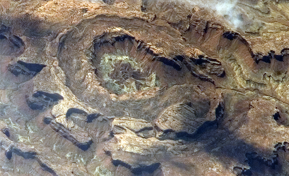
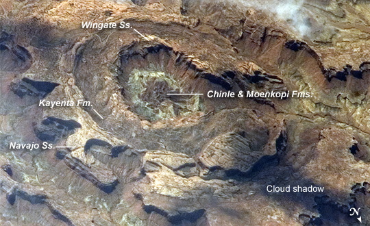
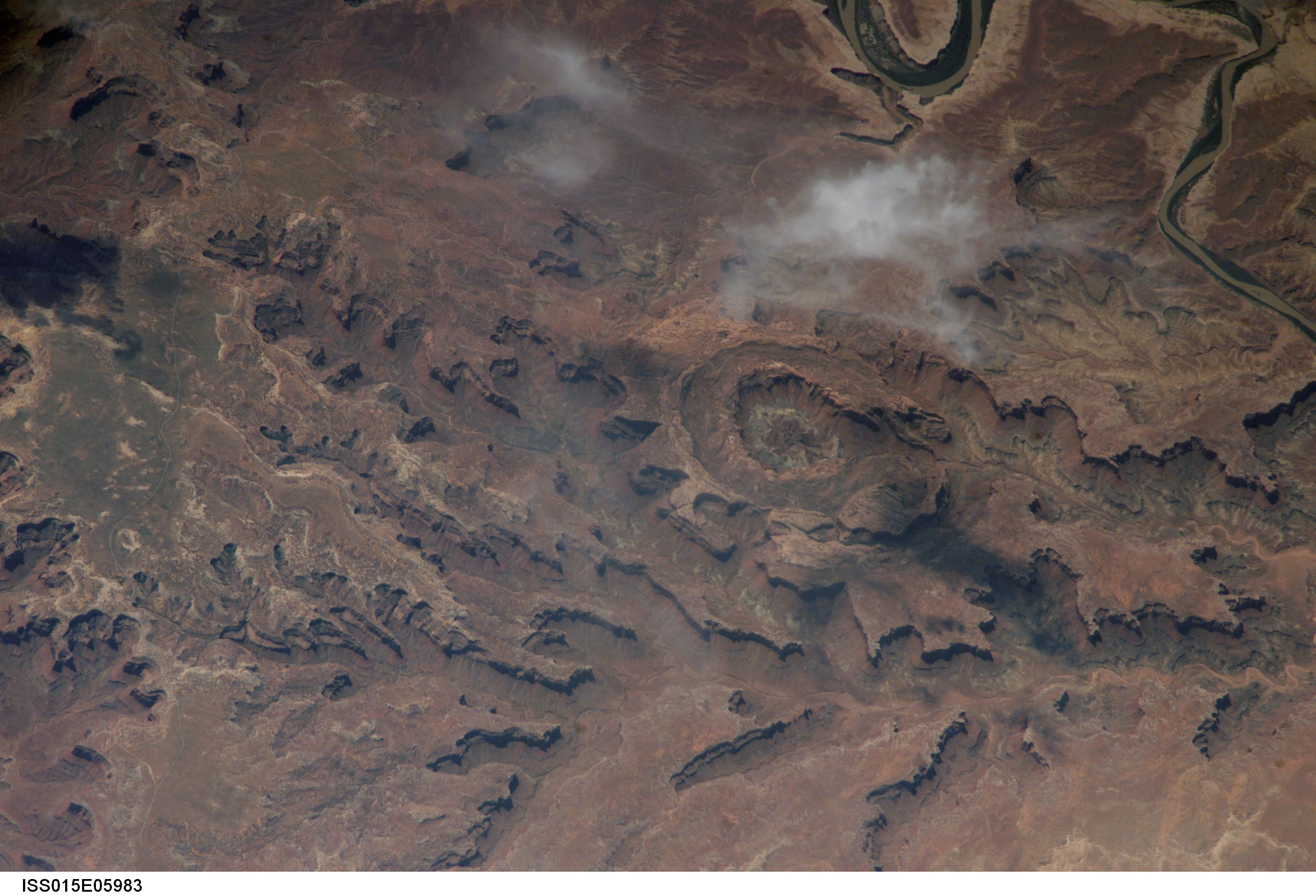
Image Caption: Upheaval Dome, Utah:
Upheaval Dome is a striking geologic structure in the Canyonlands National Park of southern Utah. Viewed from directly above (and on geologic maps), the alternating rock layers make a nearly circular, 5.5-kilometer- (3.4-mile-) diameter "bull's-eye." The oldest rocks are in the center (Chinle and Moenkopi Formations, with limited exposures of even older rocks), and progressively younger rocks are exposed farther out: Wingate Sandstone, Kayenta Formation, and Navajo Sandstone (in order of decreasing age). This kind of rock formation--a fold in the Earth's crust in which the rocks slope downward from either side of a central point--is called an anticline. If the exposed rock layers form a closed circle at the surface, the anticline is called a dome. It is typical of these formations for the central rocks to be the oldest.
This photograph of Upheaval Dome was taken by an astronaut onboard the International Space Station. The oblique viewing angle--in other words, not looking straight down--provides a sense of the topography within and around the structure. The dome appears more like an ellipse than a circle due to the oblique viewing perspective. Dark regions in the image are cloud and cliff shadows.
Scientists propose at least two ideas about how Upheaval Dome formed. Some believe that the dome is a sign of a sub-surface salt dome--a rising plug of relatively low-density salt that caused overlying rock layers to dome up in a circular pattern like a basketball underneath a blanket. The overlying rock layers were uplifted and then eroded, leaving the bull's-eye surface pattern.
Another hypothesis identifies Upheaval Dome as an impact structure, caused by a meteor striking the Earth approximately 60 million years ago. In this interpretation, the erosion-resistant Navajo and Wingate Sandstones define multiple crater rings, while the Chinle, Moenkopi, and older rocks exposed in the middle of the dome are the central peak of the impact structure. Debate about the origin of Upheaval Dome continues; recent evidence--such as microscale deformations of the rocks and minerals that are consistent with a high-energy impact event--lends support to the impact-structure hypothesis.
