ISS015-E-5815
| NASA Photo ID | ISS015-E-5815 |
| Focal Length | 180mm |
| Date taken | 2007.04.30 |
| Time taken | 19:30:57 GMT |
Resolutions offered for this image:
662 x 1000 pixels 357 x 540 pixels 540 x 720 pixels 3032 x 2064 pixels 639 x 435 pixels
662 x 1000 pixels 357 x 540 pixels 540 x 720 pixels 3032 x 2064 pixels 639 x 435 pixels

Cloud masks available for this image:
Spacecraft nadir point: 41.1° N, 119.1° W
Photo center point: 41.4° N, 112.7° W
Photo center point by machine learning:
Photo center point: 41.4° N, 112.7° W
Photo center point by machine learning:
Nadir to Photo Center: East
Spacecraft Altitude: 178 nautical miles (330km)
Country or Geographic Name: | USA-UTAH |
Features: | GREAT SALT LAKE, PLANKTON BLOOM |
| Features Found Using Machine Learning: | |
Cloud Cover Percentage: | 10 (1-10)% |
Sun Elevation Angle: | 63° |
Sun Azimuth: | 168° |
Camera: | Kodak DCS760c Electronic Still Camera |
Focal Length: | 180mm |
Camera Tilt: | High Oblique |
Format: | 3060E: 3060 x 2036 pixel CCD, RGBG array |
Film Exposure: | |
| Additional Information | |
| Width | Height | Annotated | Cropped | Purpose | Links |
|---|---|---|---|---|---|
| 662 pixels | 1000 pixels | No | Yes | Earth From Space collection | Download Image |
| 357 pixels | 540 pixels | Yes | Yes | Earth From Space collection | Download Image |
| 540 pixels | 720 pixels | Yes | Yes | NASA's Earth Observatory web site | Download Image |
| 3032 pixels | 2064 pixels | No | No | Download Image | |
| 639 pixels | 435 pixels | No | No | Download Image |
Download Packaged File
Download a Google Earth KML for this Image
View photo footprint information
Download a GeoTIFF for this photo
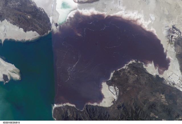
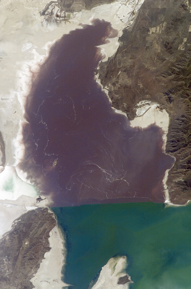
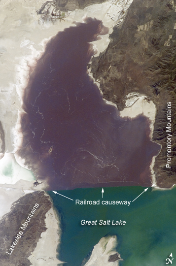
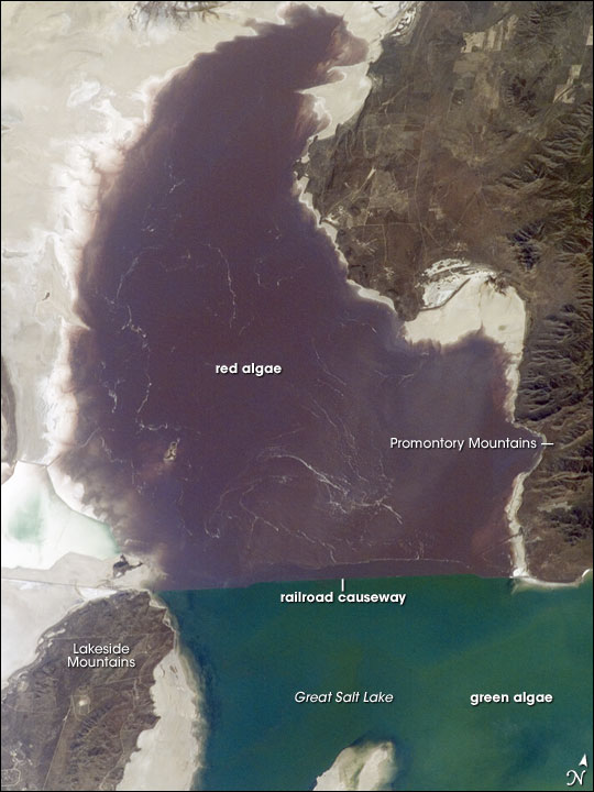
Image Caption: Algae in Great Salt Lake:
The Great Salt Lake of northern Utah is a remnant of glacial Lake Bonneville that extended over much of present-day western Utah and into the neighboring states of Nevada and Idaho approximately 32,000 to 14,000 years ago. During this time, the peaks of adjacent ranges such as the Promontory and Lakeside Mountains were most likely islands. As climate warmed and precipitation decreased in the region, glaciers that fed meltwater to Lake Bonneville disappeared, and the lake began to dry up. The present-day Great Salt Lake is a terminal lake in that water does not flow out of the lake basin. Water loss through the year is due primarily to evaporation, and when this loss exceeds input of water from rivers, streams, precipitation, and groundwater, the lake level decreases. This is particularly evident during droughts.
Evaporation and the relatively shallow water levels (maximum lake depth is around 33 feet), has led to increased salinity (dissolved salt content). The north arm of the lake, displayed in this astronaut photograph from April 30, 2007, typically has twice the salinity of the rest of the lake due to impoundment of water by a railroad causeway that crosses the lake from east to west. The causeway restricts water flow, and the separation has led to a striking division in the types of algae and bacteria found in the north and south arms of the lake. North of the causeway, the red algae Dunaliella salina and the bacterial species Halobacterium produce a pronounced reddish cast to the water, whereas south of the causeway, the water color is dominated by green algae such as Dunaliella viridis. The Great Salt Lake also supports brine shrimp and brine flies; and it is a major stopover point for migratory birds including avocets, stilts, and plovers.
