ISS015-E-10704
| NASA Photo ID | ISS015-E-10704 |
| Focal Length | 800mm |
| Date taken | 2007.06.04 |
| Time taken | 17:57:44 GMT |
Resolutions offered for this image:
1000 x 738 pixels 540 x 399 pixels 540 x 853 pixels 3032 x 2064 pixels 639 x 435 pixels
1000 x 738 pixels 540 x 399 pixels 540 x 853 pixels 3032 x 2064 pixels 639 x 435 pixels

Cloud masks available for this image:
Spacecraft nadir point: 51.1° S, 70.9° W
Photo center point: 50.9° S, 73.2° W
Photo center point by machine learning:
Photo center point: 50.9° S, 73.2° W
Photo center point by machine learning:
Nadir to Photo Center: West
Spacecraft Altitude: 181 nautical miles (335km)
Country or Geographic Name: | CHILE |
Features: | GREY GLACIER, GREY LAKE |
| Features Found Using Machine Learning: | |
Cloud Cover Percentage: | 10 (1-10)% |
Sun Elevation Angle: | 15° |
Sun Azimuth: | 342° |
Camera: | Kodak DCS760c Electronic Still Camera |
Focal Length: | 800mm |
Camera Tilt: | 38 degrees |
Format: | 3060E: 3060 x 2036 pixel CCD, RGBG array |
Film Exposure: | |
| Additional Information | |
| Width | Height | Annotated | Cropped | Purpose | Links |
|---|---|---|---|---|---|
| 1000 pixels | 738 pixels | No | Yes | Earth From Space collection | Download Image |
| 540 pixels | 399 pixels | Yes | Yes | Earth From Space collection | Download Image |
| 540 pixels | 853 pixels | Yes | Yes | NASA's Earth Observatory web site | Download Image |
| 3032 pixels | 2064 pixels | No | No | Download Image | |
| 639 pixels | 435 pixels | No | No | Download Image |
Download Packaged File
Download a Google Earth KML for this Image
View photo footprint information
Download a GeoTIFF for this photo
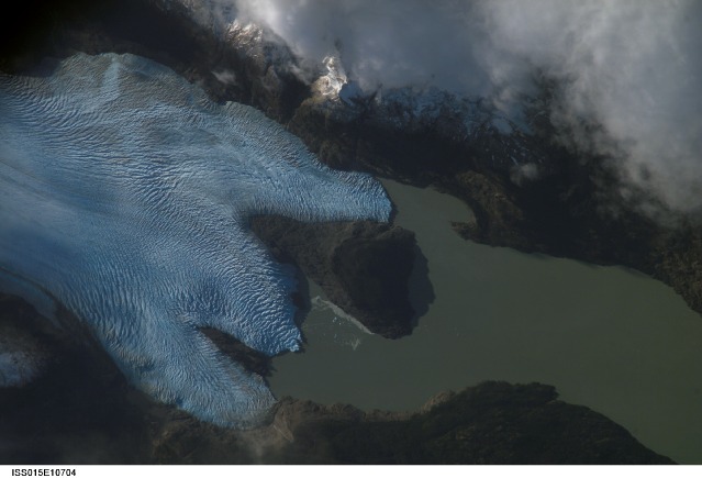
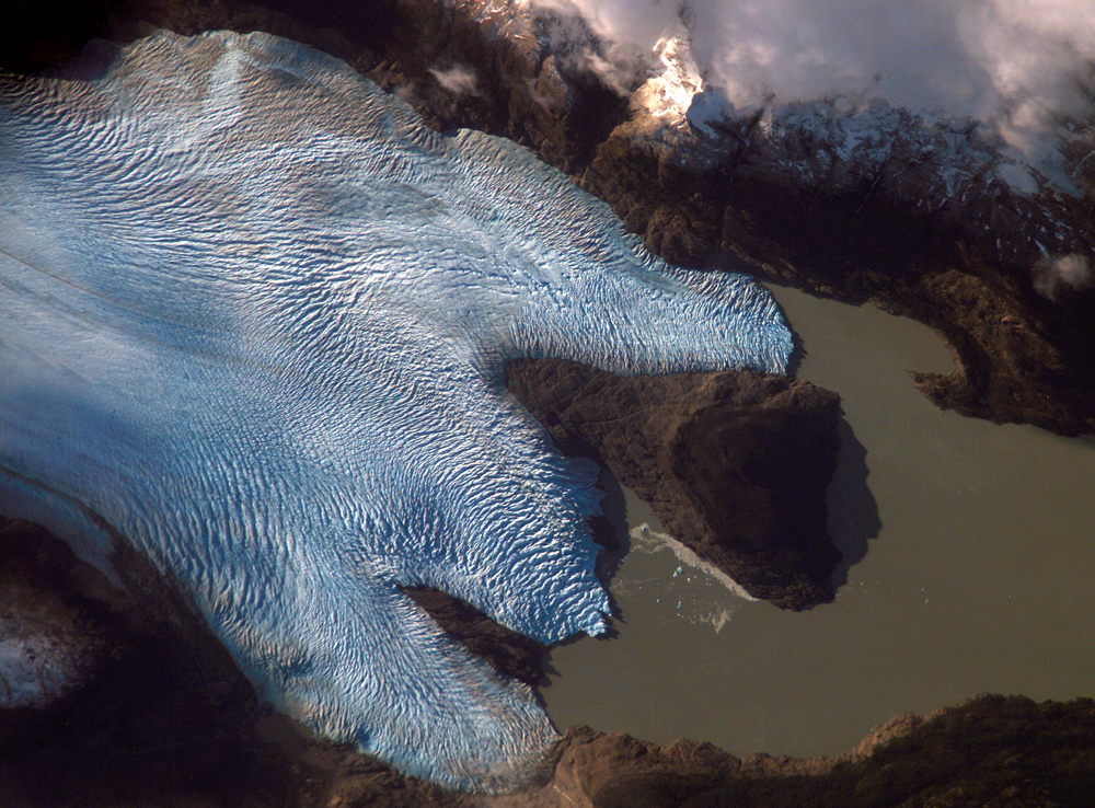
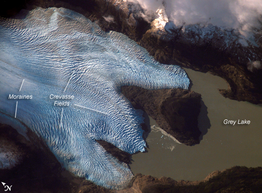
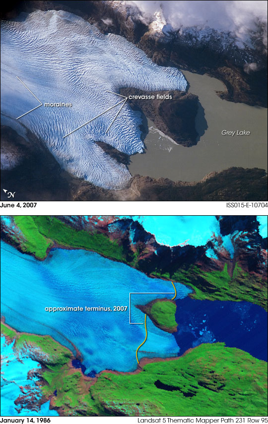
Image Caption: Grey Glacier, Chile:
The Southern Patagonian Icefield of Chile and Argentina hosts several spectacular glaciers--including Grey Glacier located in the Torres del Paine National Park in Chile. This glacier, which in 1996 had a measured total area of 270 square kilometers and a length of 28 kilometers (104 square miles in area, 17 miles long), begins in the Patagonian Andes Mountains to the west and terminates in three distinct lobes into Grey Lake. The image is a photograph taken by an astronaut aboard the International Space Station, and it captures a striking blue coloration of the glacier. The coloring is due to the ice's absorption of red wavelengths of light and scattering of blue wavelengths of light as it is transmitted through the ice.
Certain portions of the glacier visible in the image are indeed gray. Linear gray-brown moraines are accumulations of soil and rock debris that form along the edges of a glacier as it flows downhill across the landscape (much like a bulldozer blade). Glaciers flowing downslope through adjacent feeder valleys ultimately meet, and debris entrained along their sides becomes concentrated in the central portion of the resulting single, large glacier--much as smaller streams of water join to form a single large river. Three of these medial moraines are visible in the ice mass at image center left.
Gray-brown patches of debris from adjacent mountainsides color the surface of the easternmost lobe of the glacier (image top). Several crevasse fields are visible in the image. The crevasses, each a small canyon in the ice, form as a result of stress between slower- and faster-moving ice within the glacier. The crevasse patterns of Grey Glacier are complex, perhaps due to the three-lobed nature of its terminus, or end, into Grey Lake. The rugged surface of the glacier is also demonstrated by the jagged shadows it casts onto the surface of the lake.
All three lobes of Grey Glacier have retreated over the past 22 years, with the greatest loss of ice occurring along the westernmost lobe terminus. Grey Glacier, like others in southern Patagonia, loses ice from its terminus as it enters the water, a process known as calving. Calving produces large free-floating chunks of ice; some floating ice is visible near the central glacier lobe in the upper image. The observed retreat means that ice loss has been greater than ice replenishment. It is most likely due to a combination of increased regional temperatures and changes in precipitation amounts.
