ISS014-E-8179
| NASA Photo ID | ISS014-E-8179 |
| Focal Length | 180mm |
| Date taken | 2006.11.18 |
| Time taken | 19:11:00 GMT |
Resolutions offered for this image:
1000 x 629 pixels 540 x 340 pixels 540 x 334 pixels 3032 x 2064 pixels 639 x 435 pixels
1000 x 629 pixels 540 x 340 pixels 540 x 334 pixels 3032 x 2064 pixels 639 x 435 pixels


Cloud masks available for this image:
Spacecraft nadir point: 33.7° N, 86.5° W
Photo center point: 30.0° N, 90.0° W
Photo center point by machine learning:
Photo center point: 30.0° N, 90.0° W
Photo center point by machine learning:
Nadir to Photo Center: Southwest
Spacecraft Altitude: 179 nautical miles (332km)
Country or Geographic Name: | USA-LOUISIANA |
Features: | LAKE PONTCHARTRAIN, NEW ORLEANS |
| Features Found Using Machine Learning: | |
Cloud Cover Percentage: | 10 (1-10)% |
Sun Elevation Angle: | 32° |
Sun Azimuth: | 208° |
Camera: | Kodak DCS760c Electronic Still Camera |
Focal Length: | 180mm |
Camera Tilt: | High Oblique |
Format: | 3060E: 3060 x 2036 pixel CCD, RGBG array |
Film Exposure: | |
| Additional Information | |
| Width | Height | Annotated | Cropped | Purpose | Links |
|---|---|---|---|---|---|
| 1000 pixels | 629 pixels | No | Yes | Earth From Space collection | Download Image |
| 540 pixels | 340 pixels | Yes | Yes | Earth From Space collection | Download Image |
| 540 pixels | 334 pixels | Yes | Yes | NASA's Earth Observatory web site | Download Image |
| 3032 pixels | 2064 pixels | No | No | Download Image | |
| 639 pixels | 435 pixels | No | No | Download Image |
Download Packaged File
Download a Google Earth KML for this Image
View photo footprint information
Download a GeoTIFF for this photo
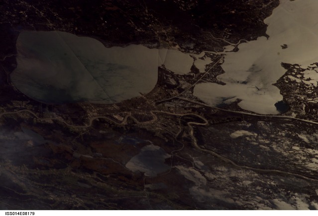
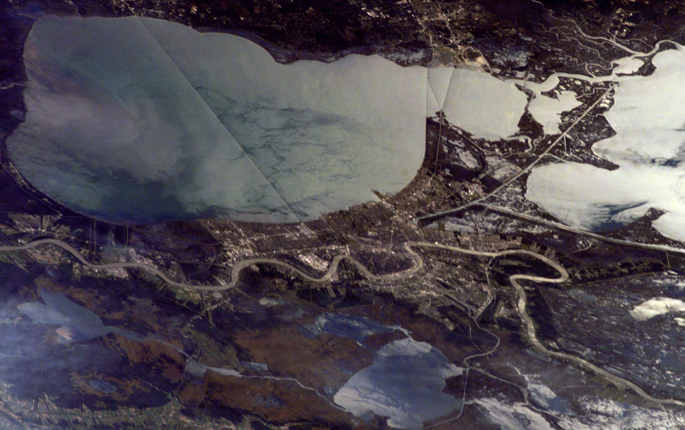
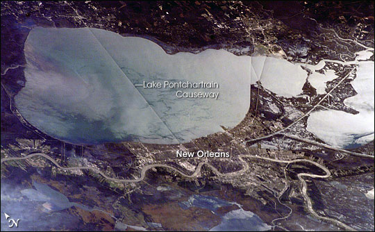
Image Caption: ISS014-E-08179 (18 Nov. 2006) --- New Orleans, Louisiana is featured in this image photographed by an Expedition 14 crewmember on the International Space Station. The location of New Orleans, in a shallow depression within unconsolidated deltaic sediments, makes it particularly vulnerable to subsidence and increased likelihood of flooding. The average elevation of metropolitan New Orleans is 1.8 meters below sea level, and a complicated system of levees, pumps, and upstream control structures on the Mississippi River is necessary to maintain dry conditions in the city. The ground subsidence occurs from groundwater withdrawal, reduction of sediment delivery by the Mississippi River, and land use changes (such as draining of wetlands) associated with continuing development. The low areas can be flooded by river floods, storm surges, or failure of levees holding back surrounding lake waters - as demonstrated catastrophically during Hurricane Katrina in 2005. Sunglint accentuates the wetland setting of New Orleans in this image by highlighting the numerous lakes, pond, and rivers (in various shades of silver-gray) surrounding the city. The view was acquired by a crewmember looking southwest from the station, which was located over north-central Alabama at the time this image was taken. Lake Pontchartrain borders New Orleans to the north, and the Lake Pontchartrain Causeway (36 kilometers in length) appears as a dark linear feature against the lake surface. Variations in surface water coloration to the east and west of the Causeway reflect the dynamics of the surface waters (including surface currents and wind-induced roughening). The patterns are made visible by the presence of surfactants on the water surface. Low cloud cover produces a blue-gray haze visible at lower left.
