ISS014-E-16597

| NASA Photo ID | ISS014-E-16597 |
| Focal Length | 400mm |
| Date taken | 2007.03.10 |
| Time taken | 12:57:13 GMT |
Resolutions offered for this image:
1000 x 678 pixels 540 x 366 pixels 540 x 405 pixels 3032 x 2064 pixels 639 x 435 pixels
1000 x 678 pixels 540 x 366 pixels 540 x 405 pixels 3032 x 2064 pixels 639 x 435 pixels
Cloud masks available for this image:
Spacecraft nadir point: 51.3° N, 7.4° W
Photo center point: 49.9° N, 6.3° W
Photo center point by machine learning:
Photo center point: 49.9° N, 6.3° W
Photo center point by machine learning:
Nadir to Photo Center: Southeast
Spacecraft Altitude: 183 nautical miles (339km)
Country or Geographic Name: | UK-ENGLAND |
Features: | ISLES OF SCILLY, WAVES, SED. |
| Features Found Using Machine Learning: | |
Cloud Cover Percentage: | 10 (1-10)% |
Sun Elevation Angle: | 35° |
Sun Azimuth: | 185° |
Camera: | Kodak DCS760c Electronic Still Camera |
Focal Length: | 400mm |
Camera Tilt: | 30 degrees |
Format: | 3060E: 3060 x 2036 pixel CCD, RGBG array |
Film Exposure: | |
| Additional Information | |
| Width | Height | Annotated | Cropped | Purpose | Links |
|---|---|---|---|---|---|
| 1000 pixels | 678 pixels | No | Yes | Earth From Space collection | Download Image |
| 540 pixels | 366 pixels | Yes | Yes | Earth From Space collection | Download Image |
| 540 pixels | 405 pixels | Yes | Yes | NASA's Earth Observatory web site | Download Image |
| 3032 pixels | 2064 pixels | No | No | Download Image | |
| 639 pixels | 435 pixels | No | No | Download Image |
Download Packaged File
Download a Google Earth KML for this Image
View photo footprint information
Download a GeoTIFF for this photo
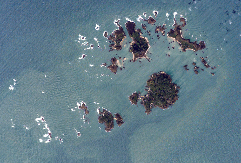
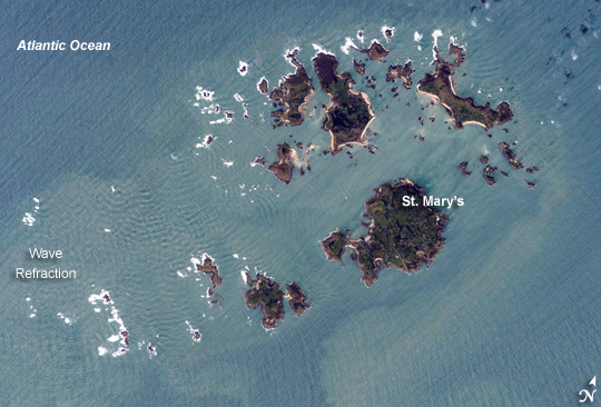
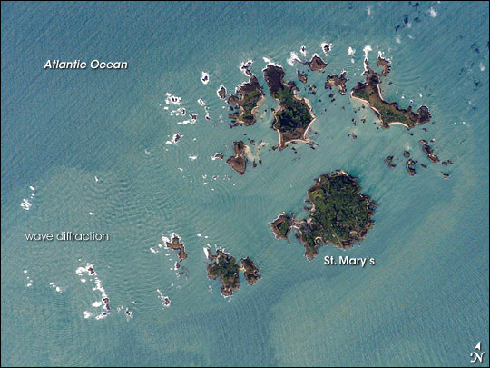
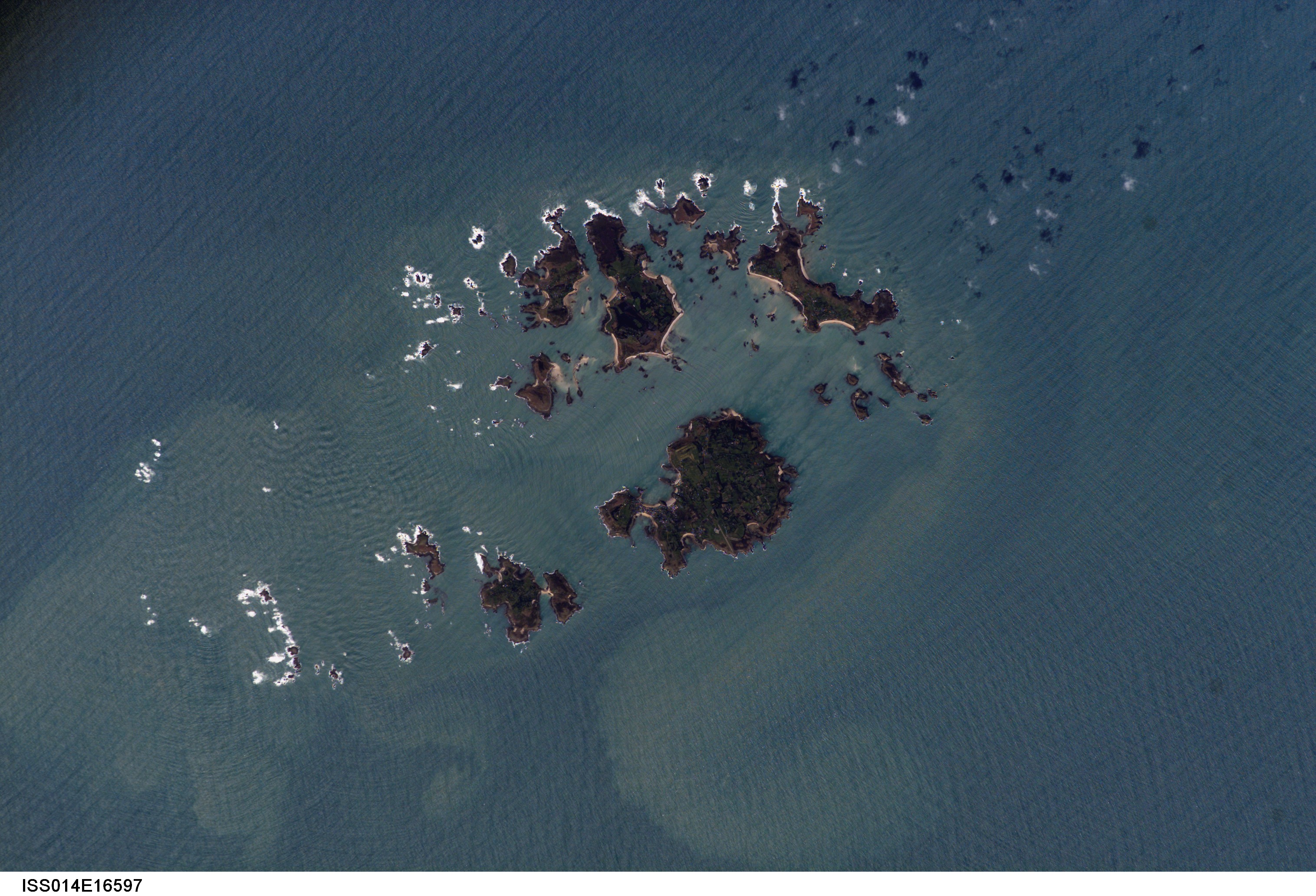
Image Caption: Isles of Scilly, UK:
The Isles of Scilly, an archipelago of approximately 150 islands, are located some 44 kilometers southwest of the westernmost point of England (Land's End). The islands are an eroded remnant of granite rock that intruded into the Earth's crust from deeper underground. They have been inhabited for over 4,000 years, and historical and geological evidence on the Isles indicates that many of the islands were larger and/or connected in the recent past. Local subsidence (sinking) or rising sea level--or both--made the connections among the islands possible. Even today, it is possible to walk between certain islands during low tides.
This astronaut photograph illustrates the geographic configuration of the archipelago and its effect on ocean wave patterns. Long, linear swells oriented northeast-southwest and moving to the southeast (from image upper left to lower right) are diffracted (bent) as they approach the coastlines and small shoals of the Isles. The wave diffraction forms complex interacting surface patterns that are most clearly visible southwest of St. Mary's island (image left). The dominant ocean wave pattern resumes to the southeast of St. Mary's, but with an additional northwest-southeast pattern superimposed, possibly due to winds originating in the English channel to the east (not shown). Suspended, tan-colored sediments visible within and around the archipelago come from wave erosion of the granite that forms the islands and from remobilization of beach sands. Bright white areas in the photograph are waves breaking on shoals.
The Isles have been designated a United Kingdom Area of Outstanding Natural Beauty due to their unique landscape, ecology, and historical significance. The potential effect of rising sea level on the Isles is a primary concern for both long-term ecosystem health and human habitability.
