ISS014-E-15732
| NASA Photo ID | ISS014-E-15732 |
| Focal Length | 800mm |
| Date taken | 2007.03.01 |
| Time taken | 06:40:47 GMT |
Resolutions offered for this image:
1000 x 658 pixels 540 x 355 pixels 540 x 405 pixels 3032 x 2064 pixels 639 x 435 pixels
1000 x 658 pixels 540 x 355 pixels 540 x 405 pixels 3032 x 2064 pixels 639 x 435 pixels

Cloud masks available for this image:
Spacecraft nadir point: 18.4° S, 27.6° E
Photo center point: 20.5° S, 26.1° E
Photo center point by machine learning:
Photo center point: 20.5° S, 26.1° E
Photo center point by machine learning:
Nadir to Photo Center: Southwest
Spacecraft Altitude: 179 nautical miles (332km)
Country or Geographic Name: | BOTSWANA |
Features: | SALT WORKS, SUA PAN |
| Features Found Using Machine Learning: | |
Cloud Cover Percentage: | 10 (1-10)% |
Sun Elevation Angle: | 35° |
Sun Azimuth: | 87° |
Camera: | Kodak DCS760c Electronic Still Camera |
Focal Length: | 800mm |
Camera Tilt: | 41 degrees |
Format: | 3060E: 3060 x 2036 pixel CCD, RGBG array |
Film Exposure: | |
| Additional Information | |
| Width | Height | Annotated | Cropped | Purpose | Links |
|---|---|---|---|---|---|
| 1000 pixels | 658 pixels | No | Yes | Earth From Space collection | Download Image |
| 540 pixels | 355 pixels | Yes | Yes | Earth From Space collection | Download Image |
| 540 pixels | 405 pixels | Yes | Yes | NASA's Earth Observatory web site | Download Image |
| 3032 pixels | 2064 pixels | No | No | Download Image | |
| 639 pixels | 435 pixels | No | No | Download Image |
Download Packaged File
Download a Google Earth KML for this Image
View photo footprint information
Download a GeoTIFF for this photo
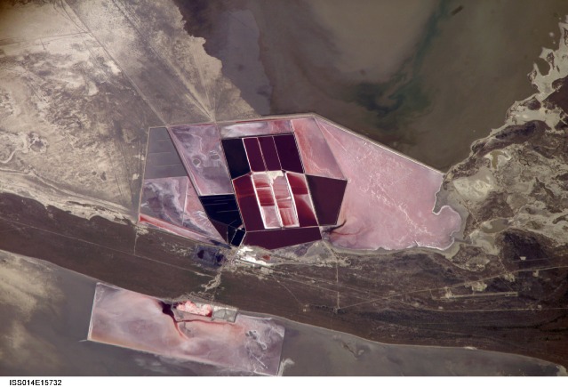
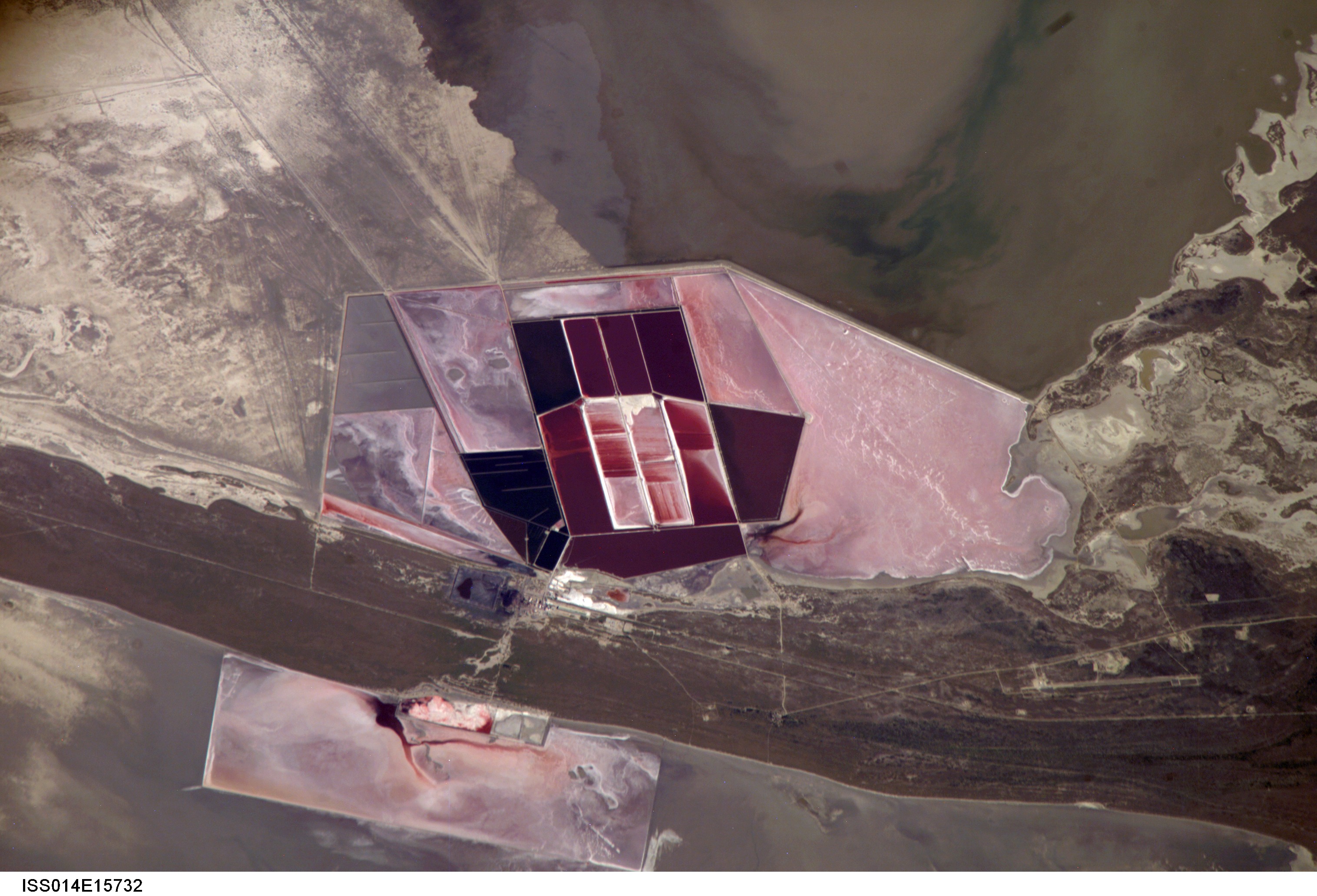
Image Caption: ISS014-E-15732 (1 March 2007) --- Salt ponds of Botswana are featured in this image photographed by an Expedition 14 crewmember on the International Space Station. This recent, detailed view shows the salt ponds of one of Africa's major producers of soda ash (sodium carbonate) and salt. Soda ash is used for glass making, in metallurgy, in the detergent industry, and in chemical manufacture. The image shows a small part of the great salt flats of central Botswana known as the Makgadikgadi Salt Pans. The soda ash and salt are both mainly exported (since 1989) to most countries in southern and central Africa. Brines from just beneath the pan floor are evaporated to produce the soda ash and salt -- a process for which the semiarid climate of Botswana is ideal. Red salt-loving algae in the ponds indicate that the salinity of the evaporating brines is medium to high. The salt pans of Botswana--a prominent visual photo target of interest for astronauts aboard the station--lie at the low point of a vast shallow continental basin. Rivers draining from as far away as central Angola - more than 1,000 kilometers away - supply water to the pans. According to scientists, during several wet climatic phases in the recent geological past the pans were permanently filled with water, for thousands of years, only to dry out when climates fluctuated to drier conditions. During dry phases water only reaches the pans underground. These are the brines that support the ash and salt industry. During wet phases when open water exists, beach ridges are constructed by wave action. One of these crosses the lower part of the view.
Salt Ponds, Botswana:
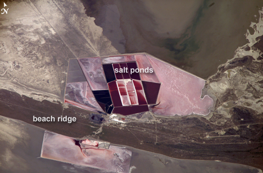
This detailed astronaut photograph shows the salt ponds of one of Africa's major producers of soda ash (sodium carbonate) and salt. Soda ash is used for making glass, in metallurgy, in the detergent industry, and in chemical manufacture. The image shows a small part of the great salt flats of central Botswana known as the Makgadikgadi Salt Pans. The soda ash and salt are mainly exported (since 1989) to countries in southern and central Africa. Salt water from just beneath the pan floor is evaporated to produce the soda ash and salt--a process for which the semiarid climate of Botswana is ideal. Red, salt-loving algae in the ponds indicate that the salinity of the evaporating water is medium to high.
The salt pans of Botswana--an easily recognizable visual feature for astronauts aboard the ISS--lie at the low point of a vast, shallow continental basin. Rivers draining from as far away as central Angola, more than 1000 kilometers (621 miles) away, supply water to the pans. During several wet climatic phases in the recent geological past, the pans were filled with water for thousands of years, only to dry out when climates fluctuated to drier conditions. During dry phases, water only reaches the pans underground. This underground, salty water supports the ash and salt industry. During wet phases, when open water exists, waves build up beach ridges. One of these ridges crosses the lower part of the view.
Additional astronaut imagery shows another prominent set of salt ponds, near the Dead Sea.
Salt Ponds, Botswana:
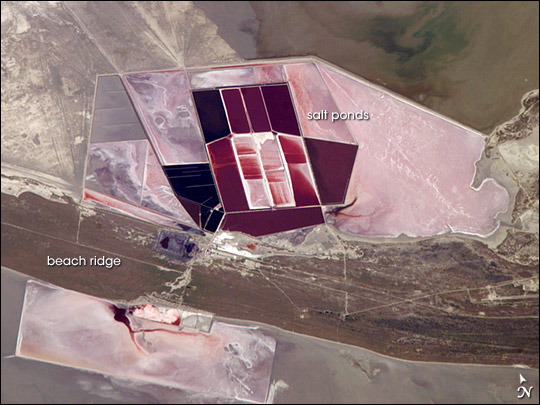
This detailed astronaut photograph shows the salt ponds of one of Africa's major producers of soda ash (sodium carbonate) and salt. Soda ash is used for making glass, in metallurgy, in the detergent industry, and in chemical manufacture. The image shows a small part of the great salt flats of central Botswana known as the Makgadikgadi Salt Pans. The soda ash and salt are mainly exported (since 1989) to countries in southern and central Africa. Salt water from just beneath the pan floor is evaporated to produce the soda ash and salt--a process for which the semiarid climate of Botswana is ideal. Red, salt-loving algae in the ponds indicate that the salinity of the evaporating water is medium to high.
The salt pans of Botswana--an easily recognizable visual feature for astronauts aboard the ISS--lie at the low point of a vast, shallow continental basin. Rivers draining from as far away as central Angola, more than 1000 kilometers (621 miles) away, supply water to the pans. During several wet climatic phases in the recent geological past, the pans were filled with water for thousands of years, only to dry out when climates fluctuated to drier conditions. During dry phases, water only reaches the pans underground. This underground, salty water supports the ash and salt industry. During wet phases, when open water exists, waves build up beach ridges. One of these ridges crosses the lower part of the view.
Additional astronaut imagery shows another prominent set of salt ponds, near the Dead Sea.
