ISS014-E-13848

| NASA Photo ID | ISS014-E-13848 |
| Focal Length | 180mm |
| Date taken | 2007.02.14 |
| Time taken | 12:48:04 GMT |
Resolutions offered for this image:
1000 x 648 pixels 540 x 350 pixels 540 x 709 pixels 540 x 354 pixels 3032 x 2064 pixels 639 x 435 pixels
1000 x 648 pixels 540 x 350 pixels 540 x 709 pixels 540 x 354 pixels 3032 x 2064 pixels 639 x 435 pixels
Cloud masks available for this image:
Spacecraft nadir point: 6.0° N, 46.4° E
Photo center point: 0.0° N, 42.8° E
Photo center point by machine learning:
Photo center point: 0.0° N, 42.8° E
Photo center point by machine learning:
Nadir to Photo Center: Southwest
Spacecraft Altitude: 188 nautical miles (348km)
Country or Geographic Name: | SOMALIA |
Features: | DUNES, INDIAN OCEAN, BACAAD |
| Features Found Using Machine Learning: | |
Cloud Cover Percentage: | 10 (1-10)% |
Sun Elevation Angle: | 32° |
Sun Azimuth: | 250° |
Camera: | Kodak DCS760c Electronic Still Camera |
Focal Length: | 180mm |
Camera Tilt: | High Oblique |
Format: | 3060E: 3060 x 2036 pixel CCD, RGBG array |
Film Exposure: | |
| Additional Information | |
| Width | Height | Annotated | Cropped | Purpose | Links |
|---|---|---|---|---|---|
| 1000 pixels | 648 pixels | No | Yes | Earth From Space collection | Download Image |
| 540 pixels | 350 pixels | Yes | Yes | Earth From Space collection | Download Image |
| 540 pixels | 709 pixels | Yes | Yes | NASA's Earth Observatory web site | Download Image |
| 540 pixels | 354 pixels | Yes | Yes | NASA's Earth Observatory web site | Download Image |
| 3032 pixels | 2064 pixels | No | No | Download Image | |
| 639 pixels | 435 pixels | No | No | Download Image |
Download Packaged File
Download a Google Earth KML for this Image
View photo footprint information
Download a GeoTIFF for this photo
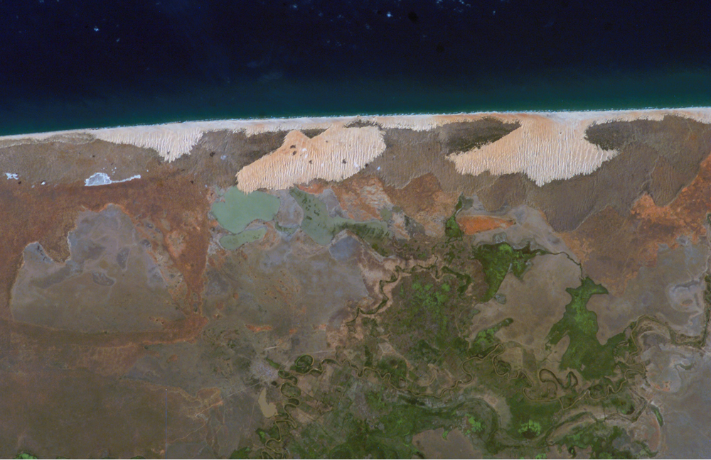
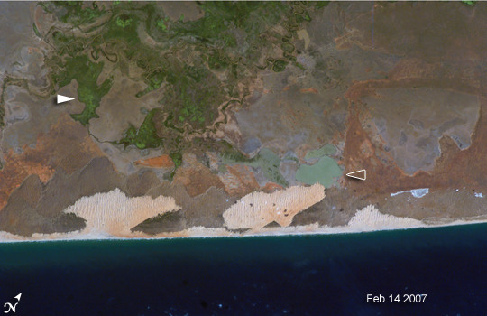
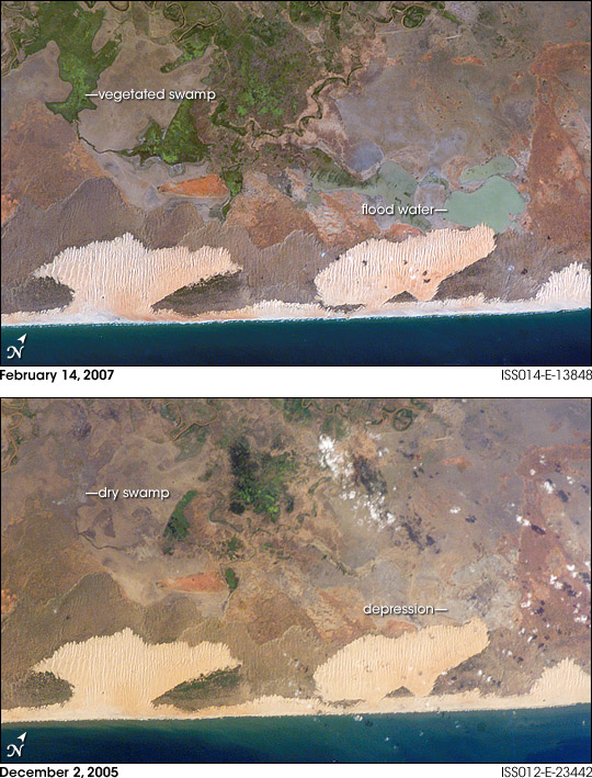
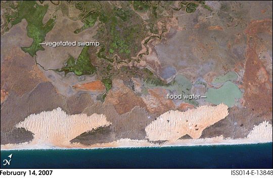
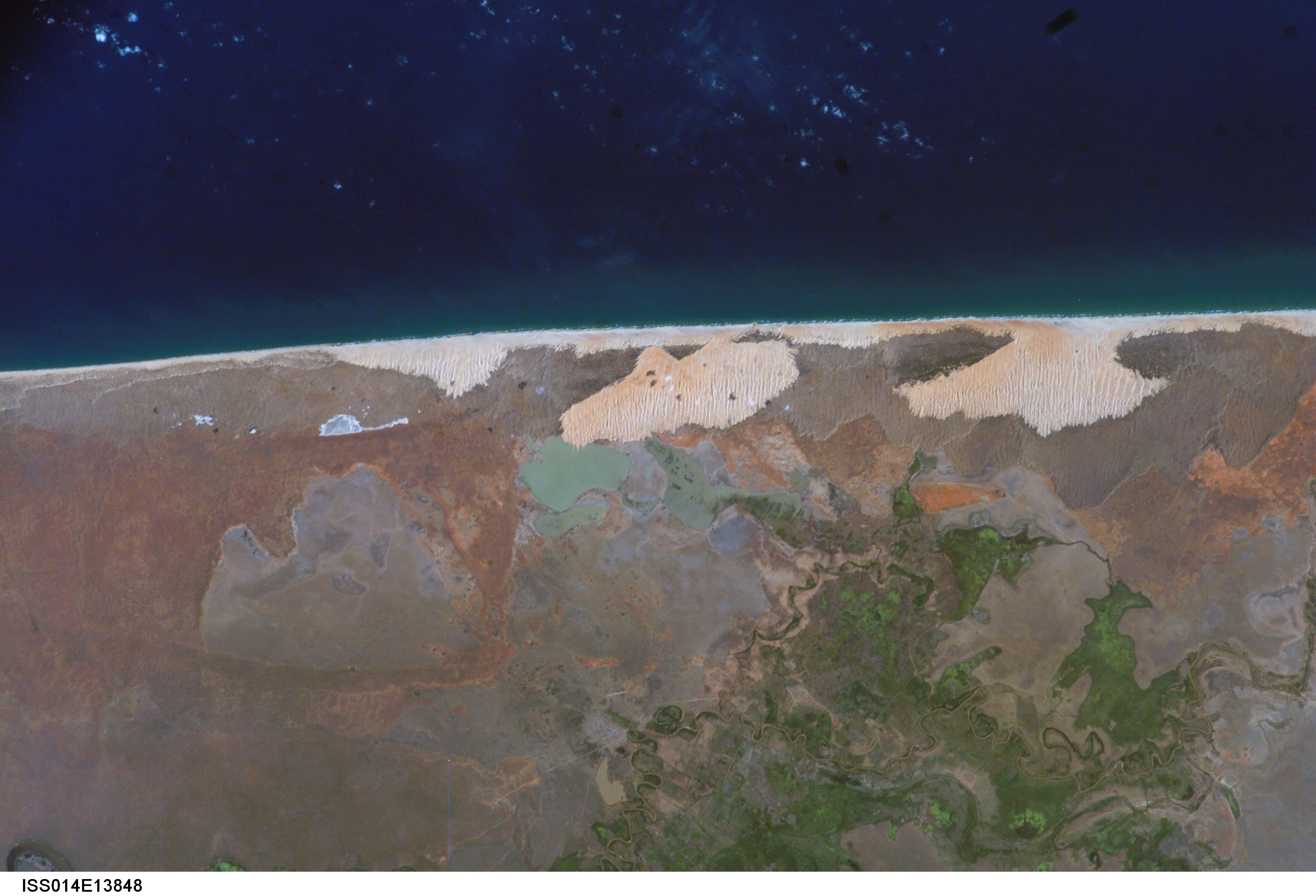
Image Caption: Flooding in Somalia:
A weak El Nino weather pattern in the tropical Pacific Ocean created ripples in the world's weather patterns in late 2006. El Nino is an episodic fluctuation in the tropical Pacific climate system that, among other consequences, causes equatorial regions around the globe to experience drought or abnormally wet conditions. The Horn of Africa frequently sees heavy precipitation during El Nino periods. Following this pattern, heavy rainfall and flooding has occurred over the region since October 2006. By late November 2006, southern Somalia and eastern Ethiopia were experiencing severe flooding that displaced hundreds of thousands of people.
These two images show the same coastal region in Somalia, south of the capital of Mogadishu (not shown), providing a visual contrast between wet and normal conditions. The images were taken on February 14, 2007, during the wetter El Nino period (top), and December 2, 2005, during more normal conditions (bottom). The February 2007 image also shows the blooming of vegetation within swamps inland of coastal dune fields. Flooding of a coastal depression by overflowing rivers and swamps is also apparent. In early March 2007, the region was experiencing outbreaks of cholera and Rift Valley Fever associated with the flooding.
