ISS014-E-10939
| NASA Photo ID | ISS014-E-10939 |
| Focal Length | 180mm |
| Date taken | 2006.12.31 |
| Time taken | 17:57:17 GMT |

Cloud masks available for this image:
Spacecraft nadir point: 29.0° N, 94.4° W
Photo center point: 29.5° N, 95.0° W
Photo center point by machine learning:
Photo center point: 29.5° N, 95.0° W
Photo center point by machine learning:
Nadir to Photo Center: Northwest
Spacecraft Altitude: 173 nautical miles (320km)
Country or Geographic Name: | USA-TEXAS |
Features: | CLEAR LAKE AREA, SHIP CHANNEL |
| Features Found Using Machine Learning: | |
Cloud Cover Percentage: | 10 (1-10)% |
Sun Elevation Angle: | 38° |
Sun Azimuth: | 173° |
Camera: | Kodak DCS760c Electronic Still Camera |
Focal Length: | 180mm |
Camera Tilt: | 15 degrees |
Format: | 3060E: 3060 x 2036 pixel CCD, RGBG array |
Film Exposure: | |
| Additional Information | |
| Width | Height | Annotated | Cropped | Purpose | Links |
|---|---|---|---|---|---|
| 3032 pixels | 2064 pixels | No | No | Download Image | |
| 639 pixels | 435 pixels | No | No | Download Image |
Download Packaged File
Download a Google Earth KML for this Image
View photo footprint information
Download a GeoTIFF for this photo
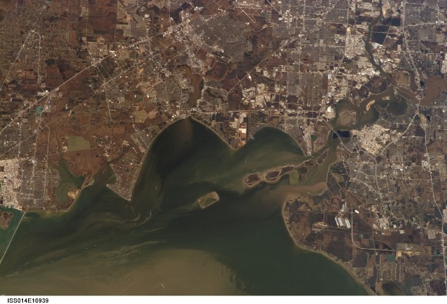
Image Caption: ISS014-E-10939 (31 Dec. 2006) --- Taken from the International Space Station on Dec. 31, 2006 and downlinked to Mission Control Center on the afternoon of Jan. 10, 2007, this picture shows parts of Galveston and Harris Counties and Galveston Bay and several communities in the Clear Lake area. NASA is visible in the picture, as well. Texas City Dike is at far left.
