ISS013-E-77377
| NASA Photo ID | ISS013-E-77377 |
| Focal Length | 800mm |
| Date taken | 2006.09.05 |
| Time taken | 12:13:09 GMT |
Resolutions offered for this image:
1000 x 596 pixels 540 x 322 pixels 540 x 405 pixels 3032 x 2064 pixels 639 x 435 pixels
1000 x 596 pixels 540 x 322 pixels 540 x 405 pixels 3032 x 2064 pixels 639 x 435 pixels
Cloud masks available for this image:
Spacecraft nadir point: 41.9° N, 10.8° E
Photo center point: 46.5° N, 8.1° E
Photo center point by machine learning:
Photo center point: 46.5° N, 8.1° E
Photo center point by machine learning:
Nadir to Photo Center: Northwest
Spacecraft Altitude: 184 nautical miles (341km)
Country or Geographic Name: | SWITZERLAND |
Features: | BERNESE ALPS, BRIENZER LAKE |
| Features Found Using Machine Learning: | |
Cloud Cover Percentage: | 10 (1-10)% |
Sun Elevation Angle: | 53° |
Sun Azimuth: | 204° |
Camera: | Kodak DCS760c Electronic Still Camera |
Focal Length: | 800mm |
Camera Tilt: | High Oblique |
Format: | 3060E: 3060 x 2036 pixel CCD, RGBG array |
Film Exposure: | |
| Additional Information | |
| Width | Height | Annotated | Cropped | Purpose | Links |
|---|---|---|---|---|---|
| 1000 pixels | 596 pixels | No | Yes | Earth From Space collection | Download Image |
| 540 pixels | 322 pixels | Yes | Yes | Earth From Space collection | Download Image |
| 540 pixels | 405 pixels | Yes | Yes | NASA's Earth Observatory web site | Download Image |
| 3032 pixels | 2064 pixels | No | No | Download Image | |
| 639 pixels | 435 pixels | No | No | Download Image |
Download Packaged File
Download a Google Earth KML for this Image
View photo footprint information
Download a GeoTIFF for this photo
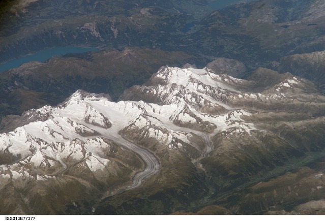
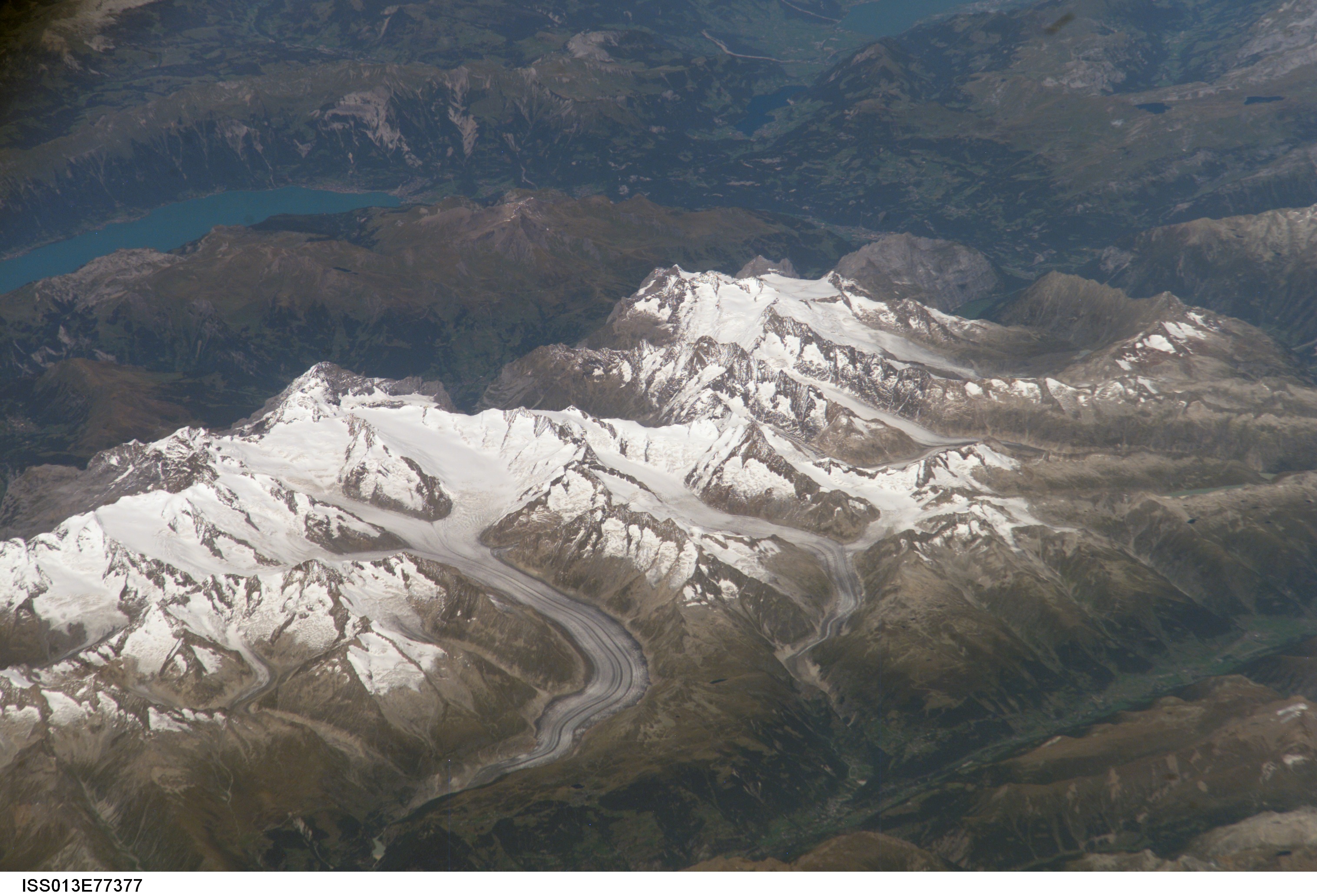
Image Caption: Bernese Alps, Switzerland:
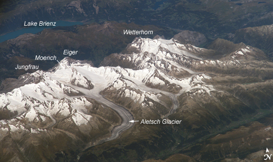
The formidable mountain system of the Alps stretches across much of central Europe, with seven countries claiming portions of the mountains within their borders: Germany, France, Switzerland, Italy, Liechtenstein, Austria, and Slovenia. The glacial landscape of the Bernese Alps, located in southwestern Switzerland, is well illustrated by this astronaut photograph. An astronaut took this picture by looking north-northwest while the International Space Station was over the Mediterranean Sea between Corsica and Italy. This oblique viewing angle imparts a sense of perspective to the image. This type of viewing angle complements nadir,or downward-viewing, imagery of the region. Three of the higher peaks of the central Alps are visible: Jungfrau at 4,158 meters (13,642 feet); Moench at 4,089 meters (13,415 feet); and Eiger at 3,970 meters (13,025 feet).
To the east and south of the Jungfrau is the Aletsch Glacier, clearly marked by dark medial moraines extending along the glacier's length parallel to the valley axis. The medial moraines are formed from rock and soil debris collected along the sides of three mountain glaciers located near the Jungfrau and Moench peaks. As these flowing ice masses merge to form the Aletsch Glacier, the debris accumulates in the middle of the glacier and is carried along the flow direction. Lake Brienz to the northwest results from the actions of both glacial ice and the flowing waters of the Aare and Lutschine rivers, and has a maximum depth of 261 meters (856 feet). The lake has a particularly fragile ecosystem, as demonstrated by the almost total collapse of the whitefish population in 1999. Possible causes for the collapse include increased water turbidity associated with upstream hydropower plant operations, and reduction of phosphorus--a key nutrient for lake algae, and a basic element of the local food web--due to water quality changes.
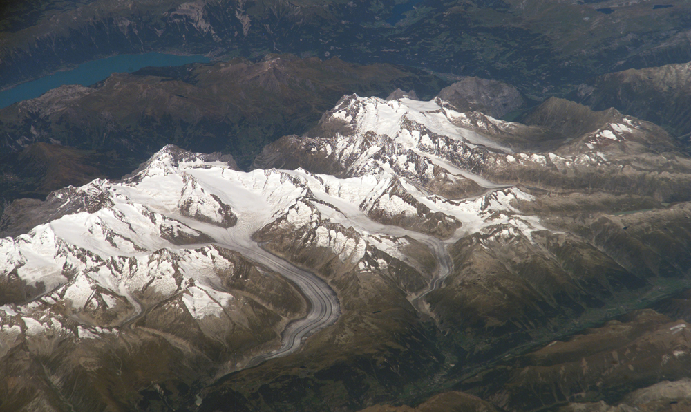
ISS013-E-77377 (5 Sept. 2006) --- Bernese Alps, Switzerland is featured in this image photographed by an Expedition 13 crewmember onboard the International Space Station. The formidable mountain system of the Alps stretches across much of central Europe, with seven countries claiming portions of the mountains within their borders (Germany, France, Switzerland, Italy, Liechtenstein, Austria, and Slovenia). The glacial landscape of the Bernese Alps, located in southwestern Switzerland, is well illustrated by this view. The image was taken by a crewmember looking north-northwest while the station was located over the Mediterranean Sea between Corsica and Italy -- this oblique viewing angle imparts a sense of perspective to the image. This type of viewing angle complements more nadir (downward)--viewing imagery of the region. Three of the higher peaks of the central Alps are visible--Jungfrau (4,158 meters), Moench (4,089 meters), and Eiger (3,970 meters). To the east and south of the Jungfrau is the Aletsch Glacier, clearly marked by dark medial moraines extending along the glacier's length parallel to the valley axis. The moraines are formed from rock and soil debris collected along the sides of three mountain glaciers located near the Jungfrau and Moench peaks -- as these flowing ice masses merge to form the Aletsch Glacier, the debris accumulates in the middle of the glacier and is carried along the flow direction. According to geologists, Lake Brienz to the northwest was formed by the actions of both glacial ice and the flowing waters of the Aare and Lutschine rivers, and has a maximum depth of 261 meters. The lake has a particularly fragile ecosystem, as demonstrated by the almost total collapse of the whitefish population in 1999. Possible causes for the collapse, according to the scientists, include increased water turbidity associated with upstream hydropower plant operations, and reduction of phosphorus (a key nutrient for lake algae, a basic element of the local food web) due to water quality concerns.
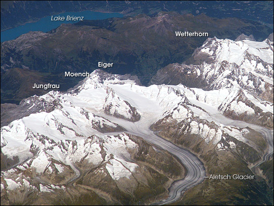
The formidable mountain system of the Alps stretches across much of central Europe, with seven countries claiming portions of the mountains within their borders: Germany, France, Switzerland, Italy, Liechtenstein, Austria, and Slovenia. The glacial landscape of the Bernese Alps, located in southwestern Switzerland, is well illustrated by this astronaut photograph. An astronaut took this picture by looking north-northwest while the International Space Station was over the Mediterranean Sea between Corsica and Italy. This oblique viewing angle imparts a sense of perspective to the image. This type of viewing angle complements nadir,or downward-viewing, imagery of the region. Three of the higher peaks of the central Alps are visible: Jungfrau at 4,158 meters (13,642 feet); Moench at 4,089 meters (13,415 feet); and Eiger at 3,970 meters (13,025 feet).
To the east and south of the Jungfrau is the Aletsch Glacier, clearly marked by dark medial moraines extending along the glacier's length parallel to the valley axis. The medial moraines are formed from rock and soil debris collected along the sides of three mountain glaciers located near the Jungfrau and Moench peaks. As these flowing ice masses merge to form the Aletsch Glacier, the debris accumulates in the middle of the glacier and is carried along the flow direction. Lake Brienz to the northwest results from the actions of both glacial ice and the flowing waters of the Aare and Lutschine rivers, and has a maximum depth of 261 meters (856 feet). The lake has a particularly fragile ecosystem, as demonstrated by the almost total collapse of the whitefish population in 1999. Possible causes for the collapse include increased water turbidity associated with upstream hydropower plant operations, and reduction of phosphorus--a key nutrient for lake algae, and a basic element of the local food web--due to water quality changes.
ISS013-E-77377 (5 Sept. 2006) --- Bernese Alps, Switzerland is featured in this image photographed by an Expedition 13 crewmember onboard the International Space Station. The formidable mountain system of the Alps stretches across much of central Europe, with seven countries claiming portions of the mountains within their borders (Germany, France, Switzerland, Italy, Liechtenstein, Austria, and Slovenia). The glacial landscape of the Bernese Alps, located in southwestern Switzerland, is well illustrated by this view. The image was taken by a crewmember looking north-northwest while the station was located over the Mediterranean Sea between Corsica and Italy -- this oblique viewing angle imparts a sense of perspective to the image. This type of viewing angle complements more nadir (downward)--viewing imagery of the region. Three of the higher peaks of the central Alps are visible--Jungfrau (4,158 meters), Moench (4,089 meters), and Eiger (3,970 meters). To the east and south of the Jungfrau is the Aletsch Glacier, clearly marked by dark medial moraines extending along the glacier's length parallel to the valley axis. The moraines are formed from rock and soil debris collected along the sides of three mountain glaciers located near the Jungfrau and Moench peaks -- as these flowing ice masses merge to form the Aletsch Glacier, the debris accumulates in the middle of the glacier and is carried along the flow direction. According to geologists, Lake Brienz to the northwest was formed by the actions of both glacial ice and the flowing waters of the Aare and Lutschine rivers, and has a maximum depth of 261 meters. The lake has a particularly fragile ecosystem, as demonstrated by the almost total collapse of the whitefish population in 1999. Possible causes for the collapse, according to the scientists, include increased water turbidity associated with upstream hydropower plant operations, and reduction of phosphorus (a key nutrient for lake algae, a basic element of the local food web) due to water quality concerns.
