ISS013-E-74843
| NASA Photo ID | ISS013-E-74843 |
| Focal Length | 180mm |
| Date taken | 2006.09.02 |
| Time taken | 15:28:25 GMT |
Resolutions offered for this image:
1000 x 1518 pixels 540 x 820 pixels 540 x 405 pixels 3032 x 2064 pixels 639 x 435 pixels
1000 x 1518 pixels 540 x 820 pixels 540 x 405 pixels 3032 x 2064 pixels 639 x 435 pixels
Cloud masks available for this image:
Spacecraft nadir point: 0.1° S, 65.4° W
Photo center point: 1.0° S, 62.5° W
Photo center point by machine learning:
Photo center point: 1.0° S, 62.5° W
Photo center point by machine learning:
Nadir to Photo Center: East
Spacecraft Altitude: 184 nautical miles (341km)
Country or Geographic Name: | BRAZIL |
Features: | NEGRO R., CAURES R., ANAVILHANAS |
| Features Found Using Machine Learning: | |
Cloud Cover Percentage: | 25 (11-25)% |
Sun Elevation Angle: | 75° |
Sun Azimuth: | 59° |
Camera: | Kodak DCS760c Electronic Still Camera |
Focal Length: | 180mm |
Camera Tilt: | 45 degrees |
Format: | 3060E: 3060 x 2036 pixel CCD, RGBG array |
Film Exposure: | |
| Additional Information | |
| Width | Height | Annotated | Cropped | Purpose | Links |
|---|---|---|---|---|---|
| 1000 pixels | 1518 pixels | No | Yes | Earth From Space collection | Download Image |
| 540 pixels | 820 pixels | Yes | Yes | Earth From Space collection | Download Image |
| 540 pixels | 405 pixels | Yes | Yes | NASA's Earth Observatory web site | Download Image |
| 3032 pixels | 2064 pixels | No | No | Download Image | |
| 639 pixels | 435 pixels | No | No | Download Image |
Download Packaged File
Download a Google Earth KML for this Image
View photo footprint information
Download a GeoTIFF for this photo
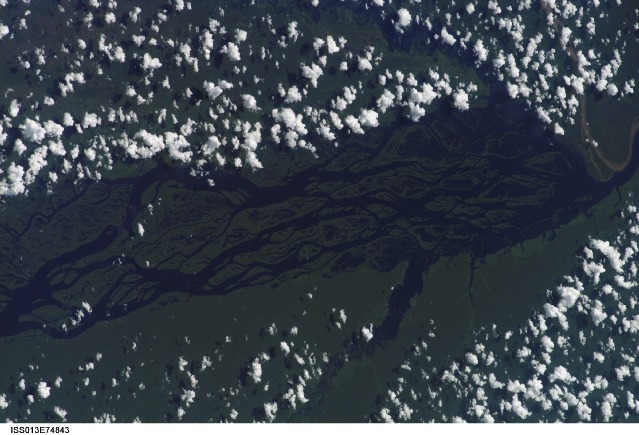
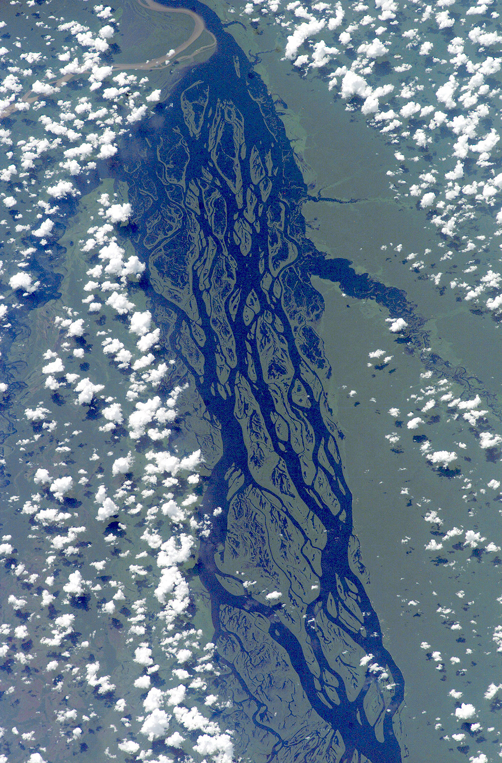
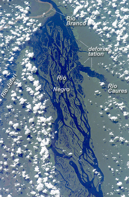
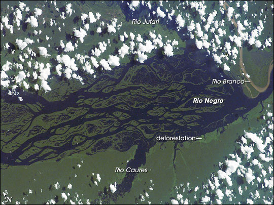
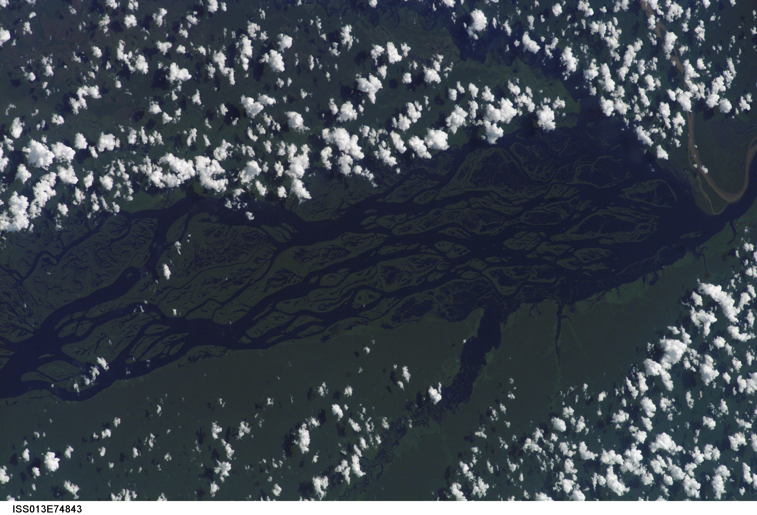
Image Caption: Rio Negro, Amazonia, Brazil:
The wide, multi-island zone in the Rio Negro (Black River) shown in this astronaut photograph from September 2, 2006, is one of two, long "archipelagoes" upstream of the city of Manaus (not shown) in central Amazonia. Sixty kilometers of the total 120-kilemeter length of this archipelago appear in this image. The direction of the river's flow is east-southeast, which is from left to right in this image; the river is about 20 kilometers wide near the right side of the image. On the day the image was taken, air temperatures over the cooler river water of the archipelago were just low enough to prevent cloud formation. Over the neighboring rainforest, temperatures were warm enough to produce small convection-related clouds, known to pilots as "popcorn" cumulus. Several zones of deforestation, represented by lighter green zones along the river banks are also visible.
Two different types of river appear in this image: black-water rivers and white-water rivers. In addition to the Rio Negro, two other "black" rivers--Rio Caures and Rio Jufari--join the Rio Negro in the scene. At the right of the image is the Rio Branco (White River), which is the largest tributary of the Rio Negro. The difference in water color is controlled by the source regions. Black-water rivers derive entirely from soils of lowland forests, rich in leaves and other decaying organic matter. Water in these rivers has the color of weak tea, which appears black in images from space. By contrast, white-water rivers like the Branco arise in mountainous country where headwater streams erode exposed rock. White-water rivers carry a load of sand and mud particles, which lighten the waters. The Amazon itself rises in the Andes Mountains, where very high rates of erosion occur, and it is thus the most famous white river in Amazonia.
This astronaut photograph was taken in September, when the rivers are near their seasonal low-water stage. Pictures taken at other times show the channels to be much wider during high-water season (May-July), when water levels rise several meters. High-resolution GPS (Global Positioning System) measurements at Manaus recently documented that the land surface actually rises vertically a small amount when the vast mass of water drains away each season. Although the rebound amount seems small, the vertical displacement--50-70 millimeters--was unexpectedly large according to the scientists who performed the study.
ISS013-E-74843 (2 Sept. 2006) --- Rio Negro in Amazonia, Brazil is featured in this image photographed by an Expedition 13 crewmember onboard the International Space Station. The wide, multi-island zone in the Rio Negro (Black River) shown in this image is one of two, long "archipelagoes" upstream of the city of Manaus (not shown) in central Amazonia. Ninety kilometers of the total 120 kilometers length of this archipelago appear in this view. On the day the photo was taken, air temperatures over the cooler river water of the archipelago were just low enough to prevent cloud formation. Over the neighboring rainforest, temperatures were warm enough to produce small convection-related clouds, known to pilots as "popcorn" cumulus. Several zones of deforestation, represented by lighter green zones along the river banks, are also visible. Two different types of river appear in this image. Flowing east-southeast (left to right) is the multi-island, Rio Negro, 20 kilometers wide near the right of the view. Two other "black" rivers, Rio Caures and Rio Jufari, join Rio Negro downstream. The second river type is the Rio Branco (White River; right) which is the largest tributary of the Rio Negro. The difference in water color is controlled by the source regions: black-water rivers derive entirely from soils of lowland forests. Water in these rivers has the color of weak tea, which appears black in images from space. By contrast, white-water rivers like the Branco carry a load of sand and mud particles, mudding the waters. The reason for the tan color is that white-water rivers rise in mountainous country where headwater streams erode exposed rock. The Amazon itself rises in the Andes Mts., where very high erosion occurs, and it is thus the most famous white river in Amazonia. This image was taken in September, near low-water stage. Pictures taken at other times show the channels much wider during high-water season (May--July) when water levels rise several meters. It was discovered recently, from high resolution GPS measurements at Manaus, that the land surface actually rises vertically a small amount in compensation when this vast mass of water drains away each season. Although small, the vertical displacement--50-70 mm--was unexpectedly large according to the scientists who performed the study.
The wide, multi-island zone in the Rio Negro (Black River) shown in this astronaut photograph from September 2, 2006, is one of two, long "archipelagoes" upstream of the city of Manaus (not shown) in central Amazonia. Sixty kilometers of the total 120-kilemeter length of this archipelago appear in this image. The direction of the river's flow is east-southeast, which is from left to right in this image; the river is about 20 kilometers wide near the right side of the image. On the day the image was taken, air temperatures over the cooler river water of the archipelago were just low enough to prevent cloud formation. Over the neighboring rainforest, temperatures were warm enough to produce small convection-related clouds, known to pilots as "popcorn" cumulus. Several zones of deforestation, represented by lighter green zones along the river banks are also visible.
Two different types of river appear in this image: black-water rivers and white-water rivers. In addition to the Rio Negro, two other "black" rivers--Rio Caures and Rio Jufari--join the Rio Negro in the scene. At the right of the image is the Rio Branco (White River), which is the largest tributary of the Rio Negro. The difference in water color is controlled by the source regions. Black-water rivers derive entirely from soils of lowland forests, rich in leaves and other decaying organic matter. Water in these rivers has the color of weak tea, which appears black in images from space. By contrast, white-water rivers like the Branco arise in mountainous country where headwater streams erode exposed rock. White-water rivers carry a load of sand and mud particles, which lighten the waters. The Amazon itself rises in the Andes Mountains, where very high rates of erosion occur, and it is thus the most famous white river in Amazonia.
This astronaut photograph was taken in September, when the rivers are near their seasonal low-water stage. Pictures taken at other times show the channels to be much wider during high-water season (May-July), when water levels rise several meters. High-resolution GPS (Global Positioning System) measurements at Manaus recently documented that the land surface actually rises vertically a small amount when the vast mass of water drains away each season. Although the rebound amount seems small, the vertical displacement--50-70 millimeters--was unexpectedly large according to the scientists who performed the study.
- References
- Bevis, M., Alsdorf, D., Kendrick, E., Fortes, L.P., Forsberg, B., Smalley, R., Jr., and Becker, J. (2005). Seasonal fluctuations in the mass of the Amazon River system and Earth's elastic response. Geophysical Research Letters,32, L16308, doi:10.1029/2005GL023491.
ISS013-E-74843 (2 Sept. 2006) --- Rio Negro in Amazonia, Brazil is featured in this image photographed by an Expedition 13 crewmember onboard the International Space Station. The wide, multi-island zone in the Rio Negro (Black River) shown in this image is one of two, long "archipelagoes" upstream of the city of Manaus (not shown) in central Amazonia. Ninety kilometers of the total 120 kilometers length of this archipelago appear in this view. On the day the photo was taken, air temperatures over the cooler river water of the archipelago were just low enough to prevent cloud formation. Over the neighboring rainforest, temperatures were warm enough to produce small convection-related clouds, known to pilots as "popcorn" cumulus. Several zones of deforestation, represented by lighter green zones along the river banks, are also visible. Two different types of river appear in this image. Flowing east-southeast (left to right) is the multi-island, Rio Negro, 20 kilometers wide near the right of the view. Two other "black" rivers, Rio Caures and Rio Jufari, join Rio Negro downstream. The second river type is the Rio Branco (White River; right) which is the largest tributary of the Rio Negro. The difference in water color is controlled by the source regions: black-water rivers derive entirely from soils of lowland forests. Water in these rivers has the color of weak tea, which appears black in images from space. By contrast, white-water rivers like the Branco carry a load of sand and mud particles, mudding the waters. The reason for the tan color is that white-water rivers rise in mountainous country where headwater streams erode exposed rock. The Amazon itself rises in the Andes Mts., where very high erosion occurs, and it is thus the most famous white river in Amazonia. This image was taken in September, near low-water stage. Pictures taken at other times show the channels much wider during high-water season (May--July) when water levels rise several meters. It was discovered recently, from high resolution GPS measurements at Manaus, that the land surface actually rises vertically a small amount in compensation when this vast mass of water drains away each season. Although small, the vertical displacement--50-70 mm--was unexpectedly large according to the scientists who performed the study.
