ISS013-E-71465
| NASA Photo ID | ISS013-E-71465 |
| Focal Length | 800mm |
| Date taken | 2006.08.27 |
| Time taken | 19:30:58 GMT |
Resolutions offered for this image:
1000 x 619 pixels 540 x 334 pixels 3032 x 2064 pixels 639 x 435 pixels
1000 x 619 pixels 540 x 334 pixels 3032 x 2064 pixels 639 x 435 pixels


Cloud masks available for this image:
Spacecraft nadir point: 18.0° N, 75.4° W
Photo center point: 15.9° N, 78.6° W
Photo center point by machine learning:
Photo center point: 15.9° N, 78.6° W
Photo center point by machine learning:
Nadir to Photo Center: Southwest
Spacecraft Altitude: 186 nautical miles (344km)
Country or Geographic Name: | CARIBBEAN SEA |
Features: | BAJO NUEVO REEF |
| Features Found Using Machine Learning: | |
Cloud Cover Percentage: | 10 (1-10)% |
Sun Elevation Angle: | 53° |
Sun Azimuth: | 262° |
Camera: | Kodak DCS760c Electronic Still Camera |
Focal Length: | 800mm |
Camera Tilt: | 51 degrees |
Format: | 3060E: 3060 x 2036 pixel CCD, RGBG array |
Film Exposure: | |
| Additional Information | |
| Width | Height | Annotated | Cropped | Purpose | Links |
|---|---|---|---|---|---|
| 1000 pixels | 619 pixels | No | Yes | Earth From Space collection | Download Image |
| 540 pixels | 334 pixels | Yes | Yes | Earth From Space collection | Download Image |
| 3032 pixels | 2064 pixels | No | No | Download Image | |
| 639 pixels | 435 pixels | No | No | Download Image |
Download Packaged File
Download a Google Earth KML for this Image
View photo footprint information
Download a GeoTIFF for this photo
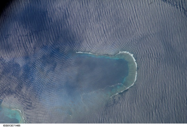
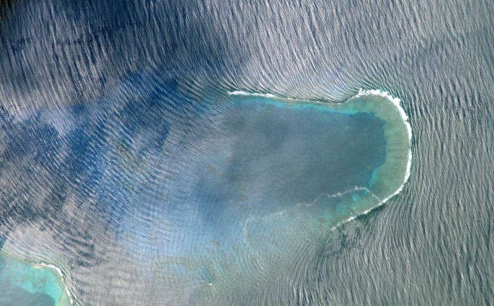
Image Caption: ISS013-E-71465 (27 Aug. 2006) --- Bajo Nuevo Reef in the western Caribbean Sea is featured in this image photographed by an Expedition 13 crewmember on the International Space Station. The Bajo Nuevo reef is approximately 26 kilometers long, comprising two separate U-shaped cays, with only tiny sandy islands associated with them. The eastern cay, shown in this image, encloses a lagoon. Protected from open-sea swells, the water surface is calmer and some back reef detail is visible within the lagoon. Cloud shadows darken the top left corner. The clearest feature is the broad pattern of swells which show two slightly different orientations, producing a tightly crossed pattern. These swells are oriented transverse to the wind direction and were probably set in motion by two different storms hundreds of kilometers east of the reef. A single irregular line of light color--also suggestive of surface oil--traces a path along the south side of the lagoon.
