ISS013-E-67242
| NASA Photo ID | ISS013-E-67242 |
| Focal Length | 180mm |
| Date taken | 2006.08.15 |
| Time taken | 22:23:46 GMT |
Resolutions offered for this image:
661 x 1000 pixels 357 x 540 pixels 540 x 540 pixels 3032 x 2064 pixels 639 x 435 pixels
661 x 1000 pixels 357 x 540 pixels 540 x 540 pixels 3032 x 2064 pixels 639 x 435 pixels

Cloud masks available for this image:
Spacecraft nadir point: 47.5° S, 178.7° E
Photo center point: 43.5° S, 173.0° E
Photo center point by machine learning:
Photo center point: 43.5° S, 173.0° E
Photo center point by machine learning:
Nadir to Photo Center: Northwest
Spacecraft Altitude: 185 nautical miles (343km)
Country or Geographic Name: | NEW ZEALAND-SI |
Features: | BANKS PEN., CHRISTCHURCH, SED. |
| Features Found Using Machine Learning: | |
Cloud Cover Percentage: | 10 (1-10)% |
Sun Elevation Angle: | 24° |
Sun Azimuth: | 28° |
Camera: | Kodak DCS760c Electronic Still Camera |
Focal Length: | 180mm |
Camera Tilt: | High Oblique |
Format: | 3060E: 3060 x 2036 pixel CCD, RGBG array |
Film Exposure: | |
| Additional Information | |
| Width | Height | Annotated | Cropped | Purpose | Links |
|---|---|---|---|---|---|
| 661 pixels | 1000 pixels | No | Yes | Earth From Space collection | Download Image |
| 357 pixels | 540 pixels | Yes | Yes | Earth From Space collection | Download Image |
| 540 pixels | 540 pixels | Yes | Yes | NASA's Earth Observatory web site | Download Image |
| 3032 pixels | 2064 pixels | No | No | Download Image | |
| 639 pixels | 435 pixels | No | No | Download Image |
Download Packaged File
Download a Google Earth KML for this Image
View photo footprint information
Download a GeoTIFF for this photo
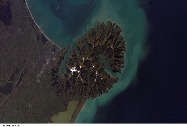
Image Caption: 250,000 Earth Photographs from the International Space Station
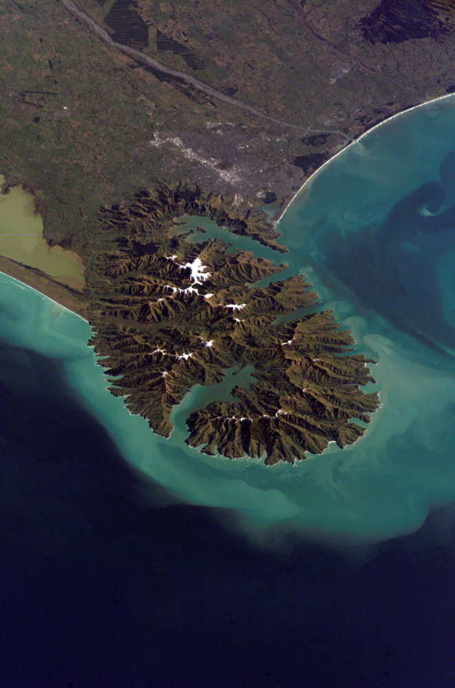
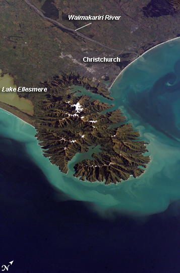
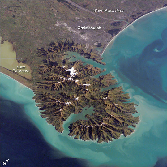
The crew of Expedition 13 recently passed a major milestone: as of late August 2006, more than one quarter of a million images of Earth had been taken from the International Space Station. The rate at which Expedition 13 has been photographing the Earth has been record-setting, as they passed the 200,000th image mark less than two months before. The 250,000th image is an oblique view (the photograph was taken from a side angle) of the city of Christchurch, New Zealand. The oblique view provides a sense of perspective and accents topography, in contrast to nadir (directly downwards) views, such as this image of Christchurch acquired by the Landsat 7 satellite in 2001.
Snow highlights the peaks of the Banks Peninsula to the southeast of the city. The peninsula has a radically different landscape compared to the adjoining, flat Canterbury Plains, where Christchurch (gray patch to the north) is located. The Banks Peninsula is formed from the overlapping cones of the extinct Lyttelton and Akaroa volcanoes. Subsequent erosion of the cones formed the heavily dissected terrain visible in the image, and sea level rise led to the creation of several harbors around the Peninsula. Erosion continues unabated today, as evidenced by the apron of greenish blue, sediment-laden waters surrounding the Banks Peninsula.
Other interesting features in the image include the braided Waimakariri River to the north-northwest of the city, and the greenish brown waters of Lake Ellesmere at image left. The coloration of the water is due both to its shallow depth (1.4 meters on average) and its high concentrations of nitrogen and phosphorus, which fertilizes the growth of large amounts of green algae.
