ISS013-E-65526
| NASA Photo ID | ISS013-E-65526 |
| Focal Length | 800mm |
| Date taken | 2006.08.08 |
| Time taken | 07:23:44 GMT |
Resolutions offered for this image:
1000 x 652 pixels 540 x 352 pixels 540 x 334 pixels 3032 x 2064 pixels 639 x 435 pixels
1000 x 652 pixels 540 x 352 pixels 540 x 334 pixels 3032 x 2064 pixels 639 x 435 pixels
Cloud masks available for this image:
Spacecraft nadir point: 25.9° N, 8.9° E
Photo center point: 26.9° N, 7.4° E
Photo center point by machine learning:
Photo center point: 26.9° N, 7.4° E
Photo center point by machine learning:
Nadir to Photo Center: Northwest
Spacecraft Altitude: 179 nautical miles (332km)
Country or Geographic Name: | ALGERIA |
Features: | ISSAOUANE DUNE SEA |
| Features Found Using Machine Learning: | |
Cloud Cover Percentage: | 10 (1-10)% |
Sun Elevation Angle: | 32° |
Sun Azimuth: | 86° |
Camera: | Kodak DCS760c Electronic Still Camera |
Focal Length: | 800mm |
Camera Tilt: | 31 degrees |
Format: | 3060E: 3060 x 2036 pixel CCD, RGBG array |
Film Exposure: | |
| Additional Information | |
| Width | Height | Annotated | Cropped | Purpose | Links |
|---|---|---|---|---|---|
| 1000 pixels | 652 pixels | No | Yes | Earth From Space collection | Download Image |
| 540 pixels | 352 pixels | Yes | Yes | Earth From Space collection | Download Image |
| 540 pixels | 334 pixels | Yes | Yes | NASA's Earth Observatory web site | Download Image |
| 3032 pixels | 2064 pixels | No | No | Download Image | |
| 639 pixels | 435 pixels | No | No | Download Image |
Download Packaged File
Download a Google Earth KML for this Image
View photo footprint information
Download a GeoTIFF for this photo
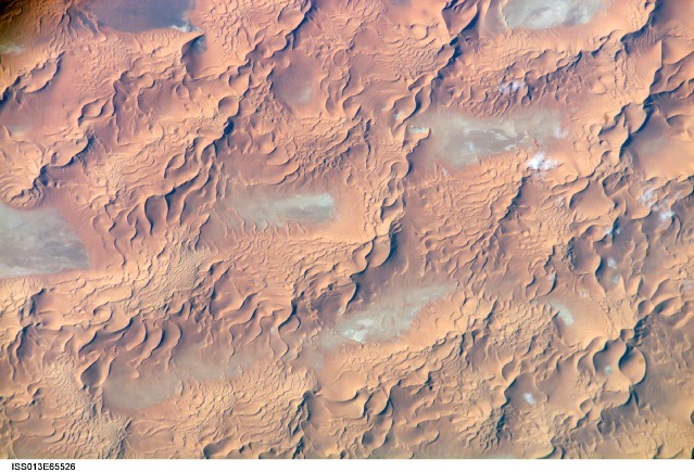
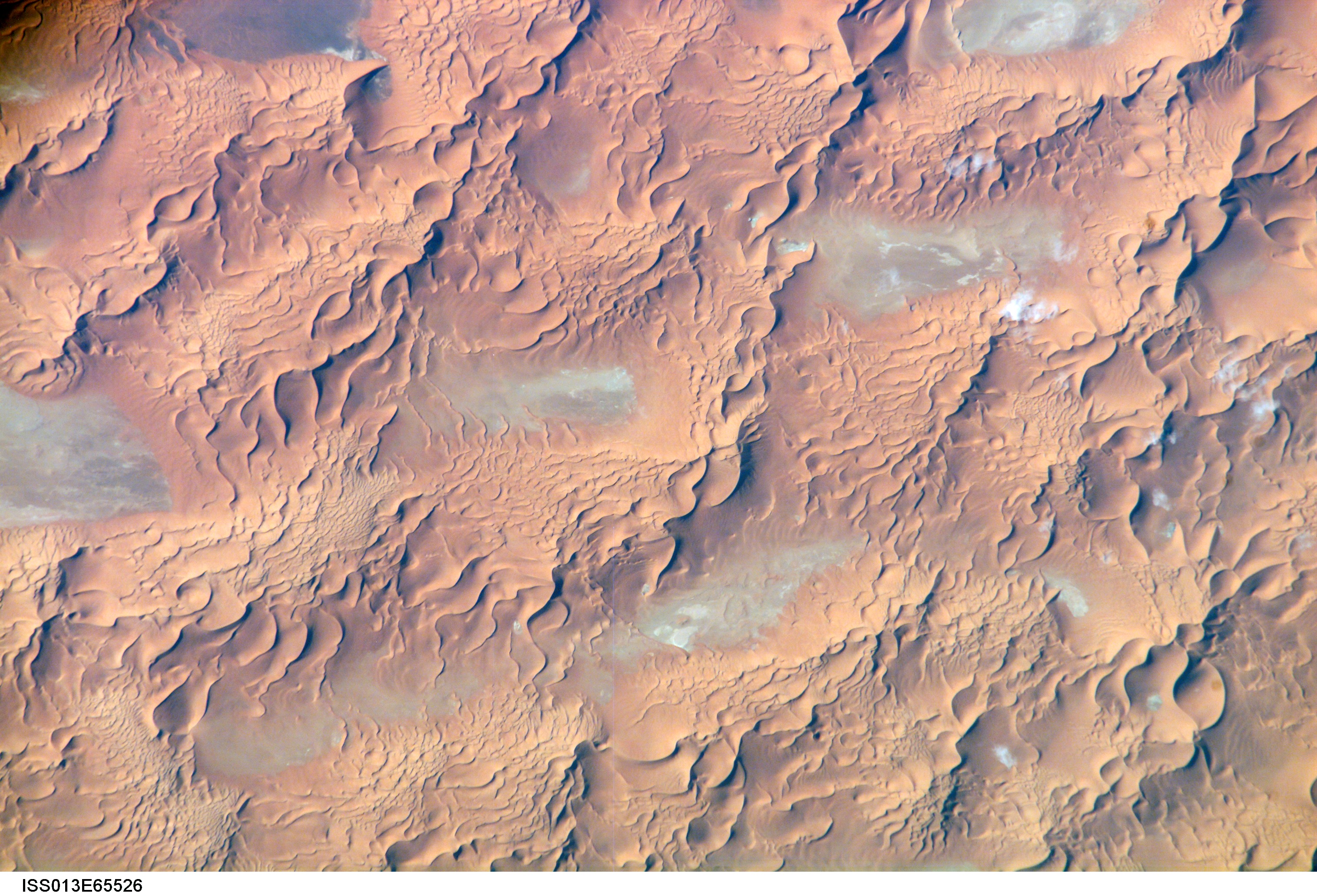
Image Caption: ISS013-E-65526 (8 Aug. 2006) --- Issaouane Dune Sea, Eastern Algeria is featured in this image photographed by an Expedition 13 crewmember on the International Space Station. This view from one of the smaller dune seas in the central Sahara shows the complex but regular patterns produced by winds in deserts where abundant sand is available. Geologists now know that dune seas (also called ergs) comprise at least three orders of dune size. In this image the largest and oldest appear here as chains oriented about 60 degrees apart, that is, one oriented almost north-south, the other southwest-northeast. The "streets" between the dune chains (also called mega-dunes) are swept clean of sand in places, revealing the original surface, with light colored muds and salt derived from very occasional rains. The chains have probably taken hundreds of thousands of years to accumulate, starting when the Sahara began to become significantly dry roughly 2.5 million years ago. Rivers became smaller, failed to reach the sea and deposited their sand load in the desert. Wind did the rest, blowing the sand into aerodynamic dune forms. According to scientists, chain trends coincide with two of the four major trends identified in the Great Eastern Sand Sea immediately to the north. Each trend likely implies a different formative wind direction--attesting to the climate shifts that have occurred since sand began to accumulate in the central Sahara. Smaller dunes are superimposed on the mega-dunes. Sinuous crest lines are the mesoscale (intermediate in size) forms, forming octopus-like crests, especially evident as the arms of star dunes. Whereas the mega-dunes are apparently stationary, studies based on aerial photographs in other parts of the world show that these dune crests move in the course of decades. The smallest dunes appear in patches on the eastern sides of the mega-dunes as a tracery of closely spaced crests. Small dunes move fast and reform quickly as stronger winds shift with the seasons. Sand grains are blown continuously from upwind dunes, across the dune-free flats. Small dunes form when the grains slow down and accumulate at the next large dune. The small dunes ride up and over the backs of the mega- and meso-dunes. Interestingly the crest orientation of the small dunes is different from that of the mesoscale dunes throughout the image. This is a common effect of wind direction shifting locally depending on dune height: the increased friction caused by larger dunes causes formative winds to blow to the left of the (weaker) winds that form the small dunes. The friction effect of larger dunes is to the right in the southern hemisphere, well illustrated on the coast of the Namib Desert.
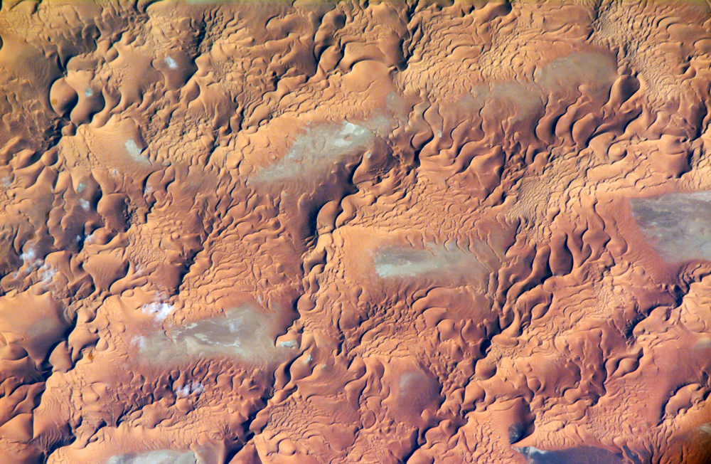
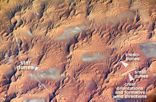
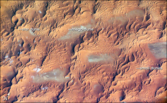
Dune Types in the Issaouane Erg, Eastern Algeria:
This view from one of the smaller dune seas in the central Sahara Desert shows the complex but regular patterns produced in deserts where wind and sand both abound. The image is centered at 26.9 North, 7.4 East, over eastern Algeria. Geologists now know that dune seas (also called ergs) exhibit at least three orders of dune size. The biggest dunes, called mega-dunes, probably took hundreds of thousands of years to accumulate, starting when the Sahara began turning arid roughly 2.5 million years ago. Rivers became smaller, failed to reach the sea, and deposited their sand load in the desert. Wind did the rest, blowing the sand into aerodynamic dune forms. Superimposed on the mega-dunes are mesoscale dunes (the prefix meso- means "intermediate.") Whereas the mega-dunes are apparently stationary, studies based on aerial photographs in other parts of the world show that mesoscale dune crests move in the course of decades. The smallest dunes form and reform the fastest, meandering over the backs of the larger dunes.
In this image, the mega-dunes appear as big, rolling lumps that zigzag toward the upper right. The "streets" between these biggest dune chains have been swept clean of sand in places, showing their original surfaces of pale mud and salts. The pale beige-grey of these areas contrasts with the otherwise burnt orange hues. Mesoscale dunes, some of which form octopus-like crests, or star dunes, mark the backs of the mega-dunes. The smallest dunes appear in patches on the eastern sides of the mega-dunes as a tracery of closely spaced crests. Interestingly, the crest orientation of the small dunes differs from the orientation of the mesoscale dunes. This difference is a common effect of local shifts in wind direction, which is influenced by dune height.
The orientation trends in the mega-dunes coincide with two of the four major trends identified in the Great Eastern Sand Sea (or Grand Erg Oriental) immediately to the north. Each orientation shift likely implies a shift in the direction of the dominant wind that formed the dunes, attesting to the climate shifts that have occurred since sand began to accumulate in the central Sahara.
