ISS013-E-34753
| NASA Photo ID | ISS013-E-34753 |
| Focal Length | 800mm |
| Date taken | 2006.06.08 |
| Time taken | 07:25:29 GMT |
1000 x 661 pixels 540 x 357 pixels 540 x 405 pixels 3032 x 2064 pixels 639 x 435 pixels
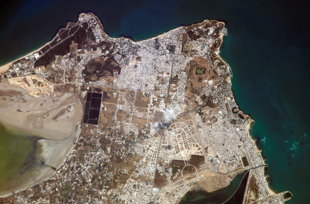
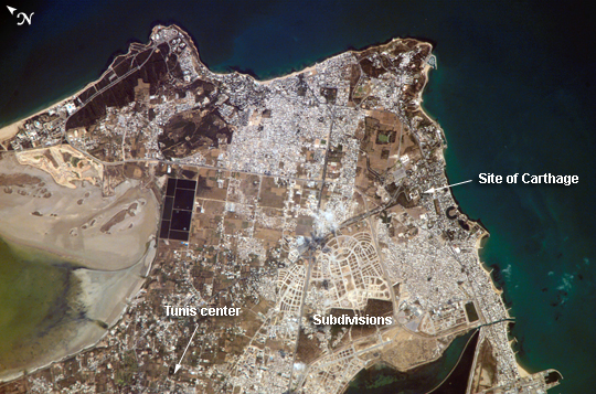
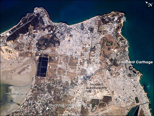
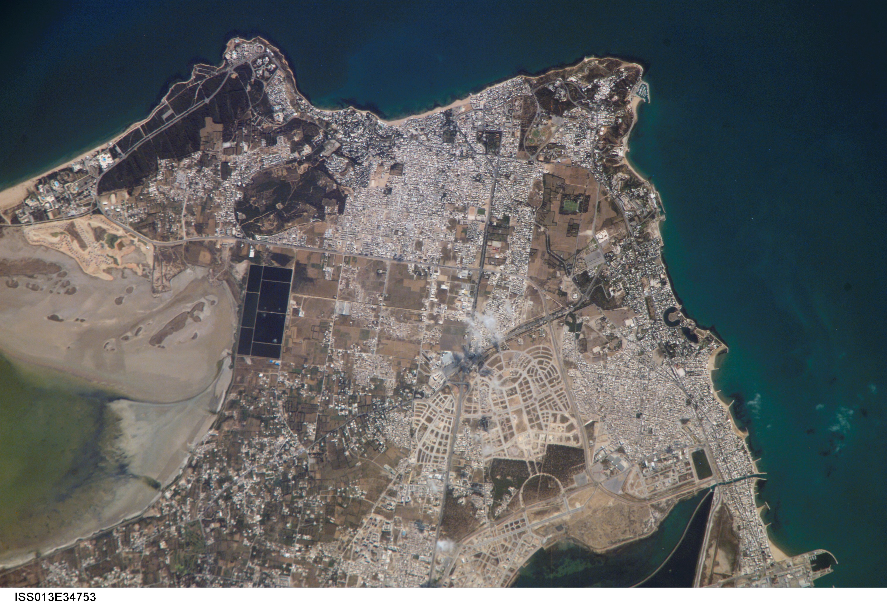
Photo center point: 36.9° N, 10.3° E
Photo center point by machine learning:
Country or Geographic Name: | TUNISIA |
Features: | CARTHAGE, GULF OF TUNIS |
| Features Found Using Machine Learning: | |
Cloud Cover Percentage: | 10 (1-10)% |
Sun Elevation Angle: | 38° |
Sun Azimuth: | 88° |
Camera: | Kodak DCS760c Electronic Still Camera |
Focal Length: | 800mm |
Camera Tilt: | 16 degrees |
Format: | 3060E: 3060 x 2036 pixel CCD, RGBG array |
Film Exposure: | |
| Additional Information | |
| Width | Height | Annotated | Cropped | Purpose | Links |
|---|---|---|---|---|---|
| 1000 pixels | 661 pixels | No | Yes | Earth From Space collection | Download Image |
| 540 pixels | 357 pixels | Yes | Yes | Earth From Space collection | Download Image |
| 540 pixels | 405 pixels | Yes | Yes | NASA's Earth Observatory web site | Download Image |
| 3032 pixels | 2064 pixels | No | No | Download Image | |
| 639 pixels | 435 pixels | No | No | Download Image |
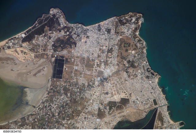
The city-state of Carthage in North Africa was founded by Phoenician settlers in 814 BC, and it subsequently became the seat of a trade empire that controlled much of the western Mediterranean region (including most of the former Phoenician lands). Carthage was completely destroyed by the Roman Republic during the Third (and final) Punic War (149-146 BC). The end of Carthage has been made notorious by the story that the Romans allegedly sowed the city with salt to ensure that no further rivals to their power would arise there. However, given the great value of salt at the time and the strategic importance of the city's location, scholars dispute whether the event actually occurred. Following the destruction of Carthage, Roman dominance of the Mediterranean continued until the fall of the Western Empire in AD 476.
The favorable location of the ancient city of Carthage is clear in this astronaut photograph. Bays along the coastline provide ready access to the Gulf of Tunis, which leads to the Mediterranean Sea. Docks along the coastline (lower right) support the shipping industry. Modern Carthage is a wealthy suburb of the Tunis metropolitan area (the center of which is located to the southwest of the image). Dense concentrations of white rooftops are obvious in the residential subdivisions to the north and south of the ancient city location. Large tracts of new developments appear to be in progress along the curving, light-colored roadways to the west of the historical city (lower image center). The green, shallow waters of an evaporating salty lake are visible at image left. Several such lakes are present in Tunisia and are centers for bird-watching tourism.
