ISS013-E-27590
| NASA Photo ID | ISS013-E-27590 |
| Focal Length | 800mm |
| Date taken | 2006.05.27 |
| Time taken | 18:32:52 GMT |
1000 x 638 pixels 540 x 345 pixels 551 x 405 pixels 1520 x 1008 pixels 639 x 435 pixels
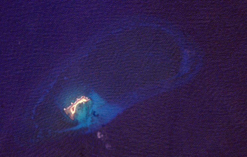
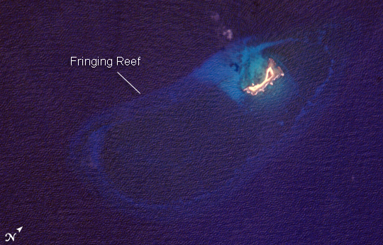
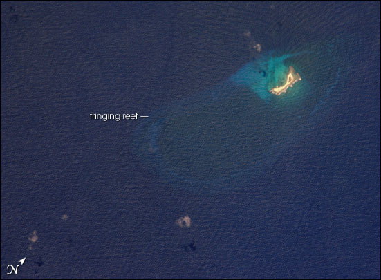

Photo center point: 15.7° N, 63.6° W
Photo center point by machine learning:
Country or Geographic Name: | CARIBBEAN SEA |
Features: | AVES ISLAND, CORAL REEFS |
| Features Found Using Machine Learning: | |
Cloud Cover Percentage: | 10 (1-10)% |
Sun Elevation Angle: | 56° |
Sun Azimuth: | 285° |
Camera: | Kodak DCS760c Electronic Still Camera |
Focal Length: | 800mm |
Camera Tilt: | 7 degrees |
Format: | 3060E: 3060 x 2036 pixel CCD, RGBG array |
Film Exposure: | |
| Additional Information | |
| Width | Height | Annotated | Cropped | Purpose | Links |
|---|---|---|---|---|---|
| 1000 pixels | 638 pixels | No | Yes | Earth From Space collection | Download Image |
| 540 pixels | 345 pixels | Yes | Yes | Earth From Space collection | Download Image |
| 551 pixels | 405 pixels | Yes | Yes | NASA's Earth Observatory web site | Download Image |
| 1520 pixels | 1008 pixels | No | No | Not enhanced | Download Image |
| 639 pixels | 435 pixels | No | No | Download Image |
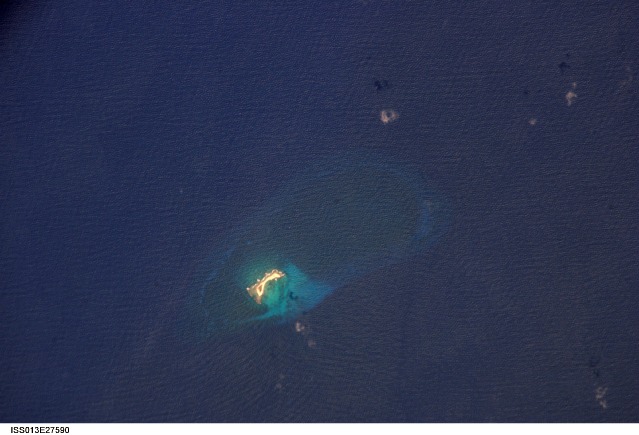
Named Isla de Aves in Spanish, (meaning "Island of the Birds") Aves Island lies west of the Lesser Antilles in the Caribbean. It provides a nesting site to green sea turtles (Chelonia mydas) and, of course, birds. Because the abundant bird droppings, known as guano, could be used in fertilizer and gunpowder, guano miners worked on the island until they depleted the supply. Since its discovery by Europeans, likely in the late 16th century, Aves Island was subsequently claimed by several European nations. The island is currently claimed by Venezuela, although disputes about ownership of the island, and the surrounding exclusive economic zone in the Caribbean, continue today.
Aves Island is small--only 0.5 by 0.2 kilometers (0.3 by 0.1 miles)--and its highest point stands just 4 meters (13 feet) above sea level. In hurricanes, the island can be completely submerged. In 1980, Hurricane Allen split the island in two, but subsequent coral reef growth reunited the two halves. This astronaut photograph is a rare, almost cloud-free, view of the island and the submerged fringing coral reef that surrounds it. The fringing reef is barely visible, appearing as a ring slightly lighter in color than the ocean water. The crosshatch-like pattern of roughness on the surrounding sea surface is most likely caused by variable winds at the time of image acquisition.
