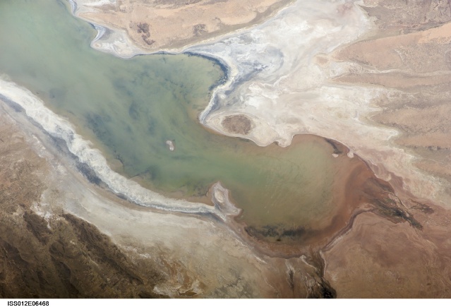
ISS012-E-6468
| NASA Photo ID | ISS012-E-6468 |
| Focal Length | 180mm |
| Date taken | 2005.11.03 |
| Time taken | 18:14:09 GMT |
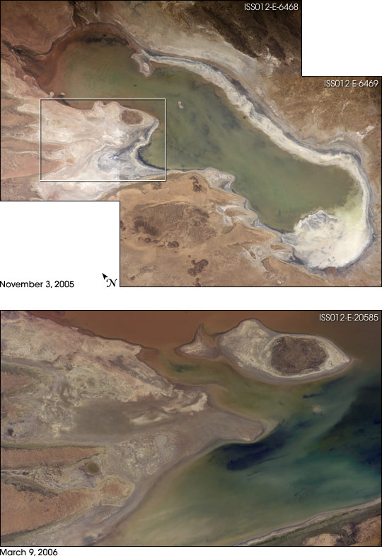

Photo center point: 19.0° S, 67.0° W
Photo center point by machine learning:
Country or Geographic Name: | BOLIVIA |
Features: | LAKE POOPO, RELICT SHORELINES |
| Features Found Using Machine Learning: | |
Cloud Cover Percentage: | 10 (1-10)% |
Sun Elevation Angle: | 61° |
Sun Azimuth: | 273° |
Camera: | Kodak DCS760c Electronic Still Camera |
Focal Length: | 180mm |
Camera Tilt: | 7 degrees |
Format: | 3060E: 3060 x 2036 pixel CCD, RGBG array |
Film Exposure: | |
| Additional Information | |
| Width | Height | Annotated | Cropped | Purpose | Links |
|---|---|---|---|---|---|
| 540 pixels | 784 pixels | Yes | Yes | NASA's Earth Observatory web site | Download Image |
| 3032 pixels | 2008 pixels | No | No | Not enhanced | Download Image |
| 639 pixels | 435 pixels | No | No | Download Image |
High-resolution images:
ISS012-E-6468 (300 kB JPEG)
ISS012-E-6469 (330 kB JPEG)
ISS012-E-20585 (270 kB JPEG)
Lake Poopo sits high in the Bolivian Andes, catching runoff from its larger neighbor to the north--Lake Titicaca (not shown)--by way of the Desaguadero River, which is the muddy area at the north end of the lake. Because Lake Poopo is very high in elevation (roughly 3,400 meters, or 11,000 feet above sea level), very shallow (generally less than 3 meters, or 9 feet), and the regional climate is very dry, small changes in precipitation in the surrounding basin have large impacts on the water levels and area of Lake Poopo. When the lake fills during wet periods, it drains from the south end into the Salar de Coipasa salt flat (not shown). Water levels in Lake Poopo are important because the lake is one of South America's largest salt-water lakes, making it a prime stop for migratory birds, including flamingoes. The lake has been designated as a RAMSAR site.
These photographs were taken in November 2005 (whole lake) and March 2006 (detail) by the Expedition 12 crew of the International Space Station. In November, water levels had dropped, exposing large tracts of salt and mud flats. A wet and cool period between December 2005 and the end of February 2006 resulted in flooding of Poopo with muddy waters from the Desaguadero River. The area of the March 9 photograph is indicated on the November 3 mosaic by a white polygon. Comparison of the photographs shows the extent of flooding of the western salt flats--sufficient to create an ephemeral island. The ISS crew is tasked to track such changes, which are related to regional weather patterns. Lake Poopo's sensitivity to precipitation in the high Andes (possibly reflecting larger climate cycles) provides an excellent visual indicator of weather and climate trends.
