ISS012-E-20456
| NASA Photo ID | ISS012-E-20456 |
| Focal Length | 400mm |
| Date taken | 2006.03.15 |
| Time taken | 06:41:17 GMT |
1000 x 729 pixels 540 x 394 pixels 540 x 679 pixels 1520 x 1008 pixels 639 x 435 pixels
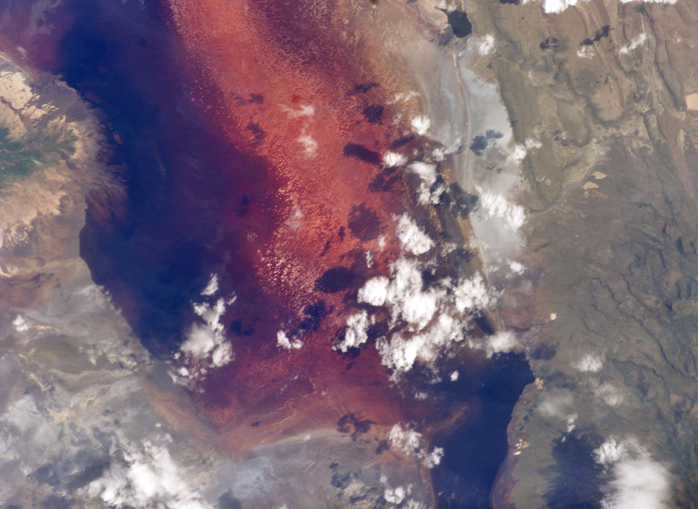
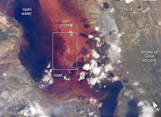

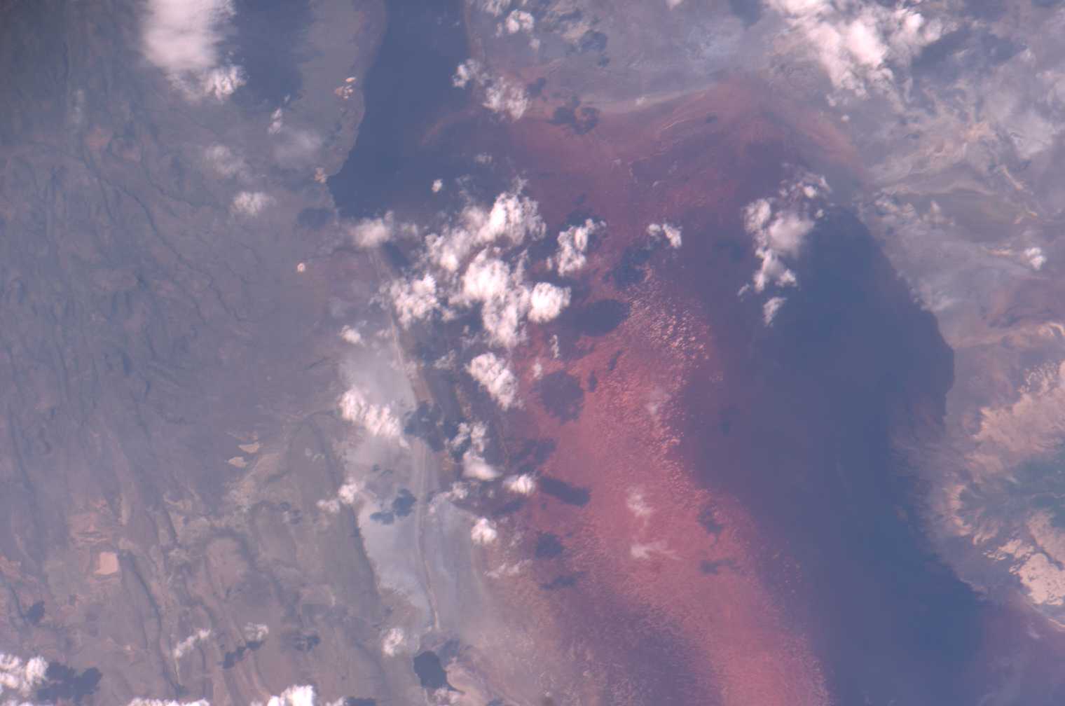
Photo center point: 2.4° S, 36.0° E
Photo center point by machine learning:
Country or Geographic Name: | TANZANIA |
Features: | LAKE NATRON, PLANKTON |
| Features Found Using Machine Learning: | |
Cloud Cover Percentage: | 10 (1-10)% |
Sun Elevation Angle: | 45° |
Sun Azimuth: | 92° |
Camera: | Kodak DCS760c Electronic Still Camera |
Focal Length: | 400mm |
Camera Tilt: | 32 degrees |
Format: | 3060E: 3060 x 2036 pixel CCD, RGBG array |
Film Exposure: | |
| Additional Information | |
| Width | Height | Annotated | Cropped | Purpose | Links |
|---|---|---|---|---|---|
| 1000 pixels | 729 pixels | No | Yes | Earth From Space collection | Download Image |
| 540 pixels | 394 pixels | Yes | Yes | Earth From Space collection | Download Image |
| 540 pixels | 679 pixels | Yes | Yes | NASA's Earth Observatory web site | Download Image |
| 1520 pixels | 1008 pixels | No | No | Not enhanced | Download Image |
| 639 pixels | 435 pixels | No | No | Download Image |
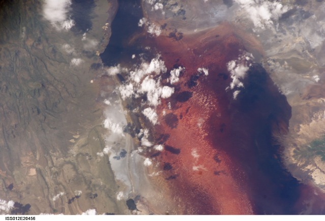
This image of the southern half of Lake Natron shows the characteristic colors of lakes where very high evaporation occurs. As water evaporates during the dry season, salinity levels increase to the point that salt-loving organisms begin to thrive. Salt-loving organisms include some cyanobacteria, tiny bacteria that grow in water and make their own food with photosynthesis as plants do. The red pigment in the cyanobacteria produce the deep reds of the open water of the lake, and orange colors of the shallow parts of the lake. In the inset, numerous, near-white salt-crust "rafts" pepper the shallowest parts of the lake. Bright white clouds are also visible just right of center and on the top margin. The lake is quite shallow, less than three meters deep, and varies in width depending on its water level. In this image, the lake is about ten kilometers wide. Tan lines run north-south, parallel to the eastern lake shore on the right side of the image. Called fault scarps, these lines are the steep, step-like slopes created when the land was pushed up during earthquakes along faults in the Great Rift Valley system of East Africa. Also part of the rift system is Gelai Volcano, the slopes of which appear in the lower right corner.
The four main environments typical of salt (alkali) lakes in East Africa are illustrated well in the image. The delta of one of two dominant streams that flow into the lake (top left) shows where fresh water enters the basin. Open water, salt flats with salt crusts, and mud flats succeed each other in a west-to-east progression towards the shallow side of the lake. Vast numbers of the pink Lesser Flamingo (2.5 million by one calculation) rely on Lake Natron as their only breeding ground in the Rift Valley. The flamingoes feed on the nutrient-rich cyanobacteria. As salinity increases, so do the number of cyanobacteria, and the lake can support more nests. Threats to the salinity balance from increased fresh water influxes will come from projected logging in Natron watersheds and a planned hydroelectric power plant. Although development plans include construction of a dike at the north end of the lake to contain the fresh water, the threat of dilution to this breeding ground may still be serious. The government of Tanzania recognized both the threat and the uniqueness of the habitat in 2001, when it placed Lake Natron on the list of Wetlands of International Importance as part of the Ramsar Convention, an intergovernmental treaty meant to protect wetlands.
Images of Lake Natron from four other dates can be seen on the Earth Observatory and associated links. The area and shape of the open water and salt-raft zones depend on lake levels, controlled mainly by local rainfall and evaporation. Patterns of these sub-environments therefore appear different across the span of a few years.
