ISS012-E-15050
| NASA Photo ID | ISS012-E-15050 |
| Focal Length | 400mm |
| Date taken | 2006.01.12 |
| Time taken | 18:39:59 GMT |
1000 x 1261 pixels 540 x 681 pixels 540 x 540 pixels 1520 x 1008 pixels 639 x 435 pixels
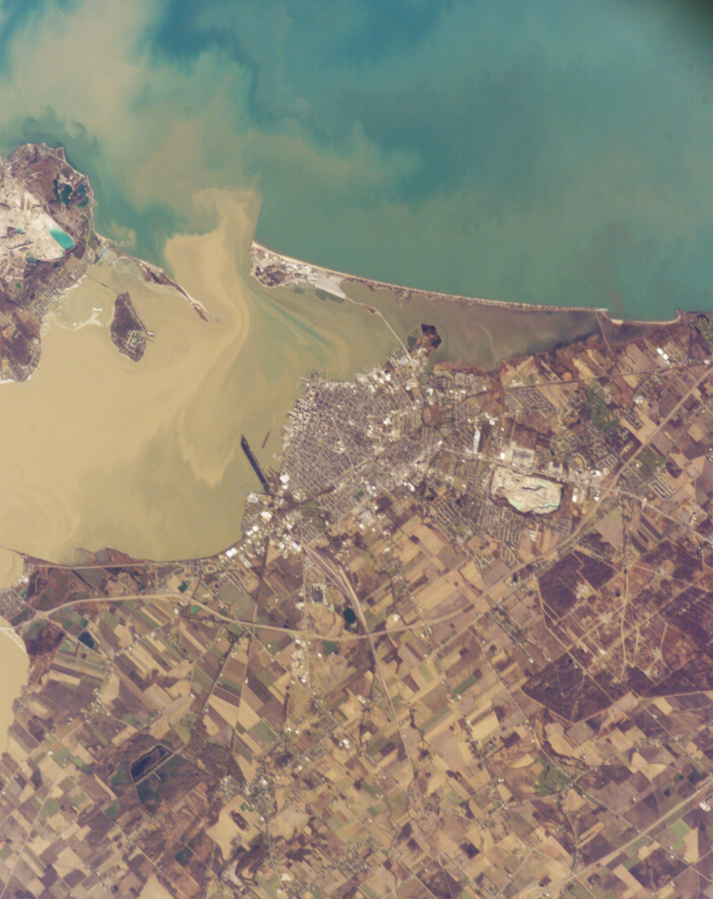
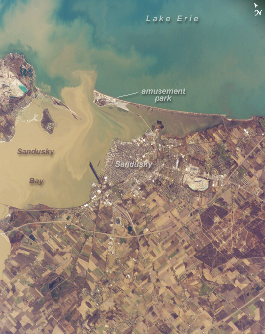
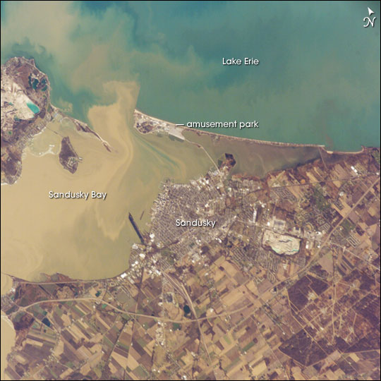
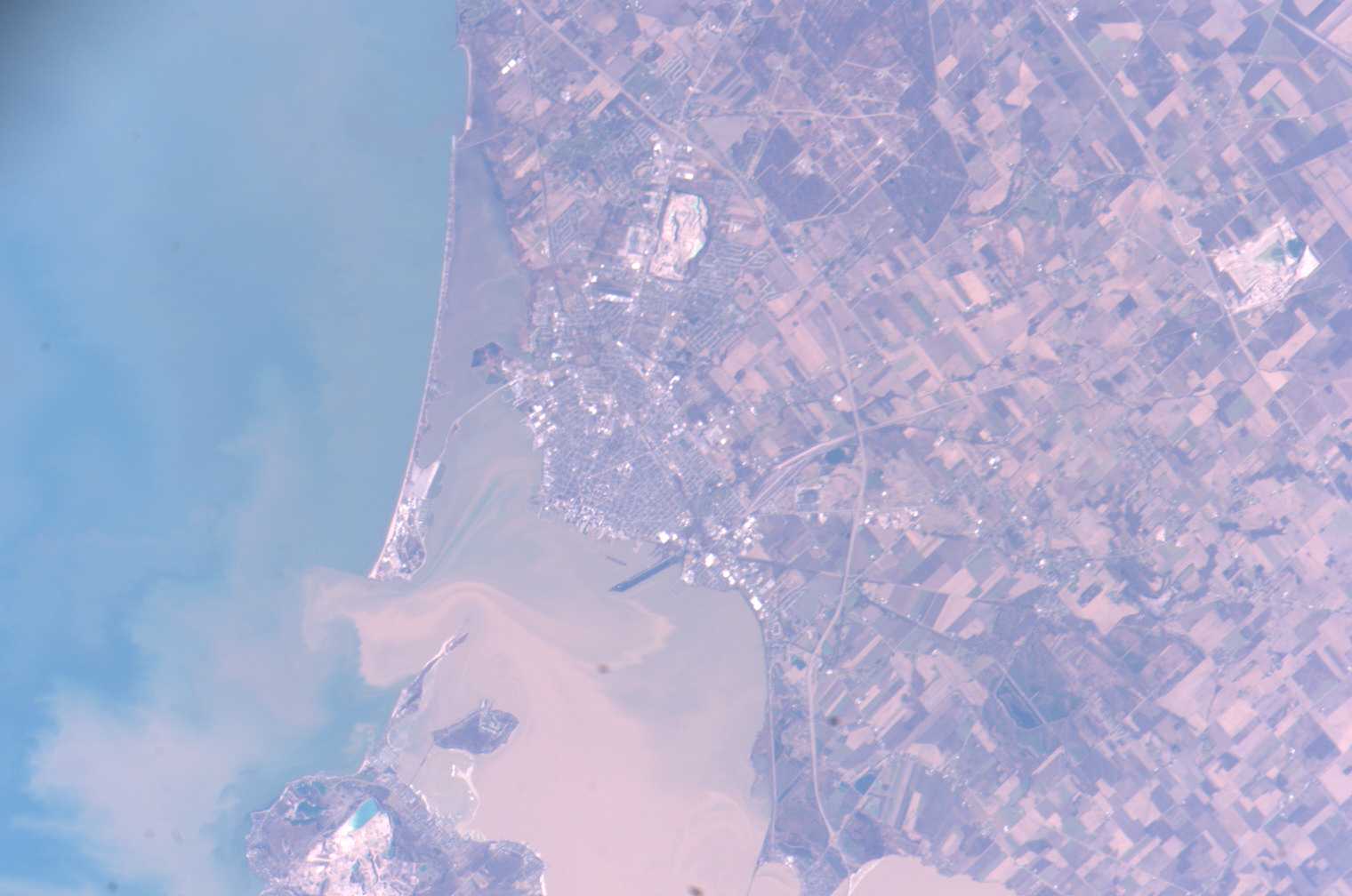
Photo center point: 41.4° N, 82.7° W
Photo center point by machine learning:
Country or Geographic Name: | USA-OHIO |
Features: | SANDUSKY, BAY, SED. PLUMES |
| Features Found Using Machine Learning: | |
Cloud Cover Percentage: | 10 (1-10)% |
Sun Elevation Angle: | 25° |
Sun Azimuth: | 197° |
Camera: | Kodak DCS760c Electronic Still Camera |
Focal Length: | 400mm |
Camera Tilt: | 31 degrees |
Format: | 3060E: 3060 x 2036 pixel CCD, RGBG array |
Film Exposure: | |
| Additional Information | |
| Width | Height | Annotated | Cropped | Purpose | Links |
|---|---|---|---|---|---|
| 1000 pixels | 1261 pixels | No | Yes | Earth From Space collection | Download Image |
| 540 pixels | 681 pixels | Yes | Yes | Earth From Space collection | Download Image |
| 540 pixels | 540 pixels | Yes | Yes | NASA's Earth Observatory web site | Download Image |
| 1520 pixels | 1008 pixels | No | No | Not enhanced | Download Image |
| 639 pixels | 435 pixels | No | No | Download Image |
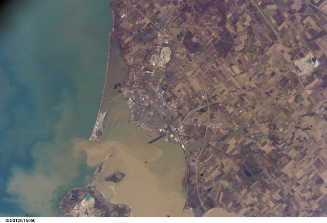
Muddy brown water fills Sandusky Bay, just south of Lake Erie in this astronaut photograph. The small city of Sandusky occupies the southeastern shore of the bay. Highway 2 can be seen arcing around the south side of the city. Ferries connect Sandusky to Pelee Island (not visible) in the middle of the lake. In earlier days, Sandusky Bay was known as one of the port sites best protected from rough waters in the Great Lakes.
The most striking aspect of this image is the flow of the brown water in and out of the mouth of the bay. Slight movement of lake surface water, driven mainly by wind, causes a small ebb and flow of bay water. Sediment-charged water is derived from agricultural fields along the Sandusky River upstream. Mud plumes in Lake Erie originate from prior pulses of muddy water from the bay. When this image was taken, some clear, lake water (blue-green strip) appeared to be flowing into the bay.
Sandusky lies midway between Toledo and Cleveland, both about an hour's drive away. Sandusky has a diverse economic base in engineering and chemical plants, as well as boasting one of the most popular vacation destinations in the United States, drawing millions of visitors each year to its very large amusement park, located on the eastern spit between Sandusky Bay and Lake Erie. NASA Glenn Research Center - Plum Brook Station also appears in this image, in the lower right corner.
